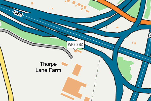
WF3 3BZ is located in the Ardsley & Robin Hood electoral ward, within the metropolitan district of Leeds and the English Parliamentary constituency of Morley and Outwood. The Sub Integrated Care Board (ICB) Location is NHS West Yorkshire ICB - 15F and the police force is West Yorkshire. This postcode has been in use since January 1980.


GetTheData
Source: OS OpenMap – Local (Ordnance Survey)
Source: OS VectorMap District (Ordnance Survey)
Licence: Open Government Licence (requires attribution)
| Easting | 432017 |
| Northing | 426190 |
| Latitude | 53.731145 |
| Longitude | -1.516177 |
GetTheData
Source: Open Postcode Geo
Licence: Open Government Licence
| Country | England |
| Postcode District | WF3 |
| ➜ WF3 open data dashboard ➜ See where WF3 is on a map | |
GetTheData
Source: Land Registry Price Paid Data
Licence: Open Government Licence
Elevation or altitude of WF3 3BZ as distance above sea level:
| Metres | Feet | |
|---|---|---|
| Elevation | 100m | 328ft |
Elevation is measured from the approximate centre of the postcode, to the nearest point on an OS contour line from OS Terrain 50, which has contour spacing of ten vertical metres.
➜ How high above sea level am I? Find the elevation of your current position using your device's GPS.
GetTheData
Source: Open Postcode Elevation
Licence: Open Government Licence
| Ward | Ardsley & Robin Hood |
| Constituency | Morley And Outwood |
GetTheData
Source: ONS Postcode Database
Licence: Open Government Licence
| June 2022 | Anti-social behaviour | On or near Long Thorpe Lane | 376m |
| May 2022 | Other crime | On or near Gilwell Court | 428m |
| April 2022 | Violence and sexual offences | On or near Hyde Way | 489m |
| ➜ Get more crime data in our Crime section | |||
GetTheData
Source: data.police.uk
Licence: Open Government Licence
| Long Thorpe Lane | Thorpe | 227m |
| Long Thorpe Lane M1 Motorway (Long Thorpe Lane) | Thorpe | 242m |
| Longthorpe Lane Lingwell Gate Ln (Longthorpe Lane) | Thorpe | 393m |
| Longthorpe Lane Lingwell Gate Ln (Longthorpe Lane) | Thorpe | 395m |
| Lingwell Gate Lane Dolphin Ln (Lingwell Gate Lane) | Thorpe | 511m |
| Outwood Station | 1.8km |
| Morley Station | 5.4km |
| Woodlesford Station | 5.6km |
GetTheData
Source: NaPTAN
Licence: Open Government Licence
| Percentage of properties with Next Generation Access | 100.0% |
| Percentage of properties with Superfast Broadband | 0.0% |
| Percentage of properties with Ultrafast Broadband | 0.0% |
| Percentage of properties with Full Fibre Broadband | 0.0% |
Superfast Broadband is between 30Mbps and 300Mbps
Ultrafast Broadband is > 300Mbps
| Percentage of properties unable to receive 2Mbps | 0.0% |
| Percentage of properties unable to receive 5Mbps | 0.0% |
| Percentage of properties unable to receive 10Mbps | 0.0% |
| Percentage of properties unable to receive 30Mbps | 100.0% |
GetTheData
Source: Ofcom
Licence: Ofcom Terms of Use (requires attribution)
GetTheData
Source: ONS Postcode Database
Licence: Open Government Licence


➜ Get more ratings from the Food Standards Agency
GetTheData
Source: Food Standards Agency
Licence: FSA terms & conditions
| Last Collection | |||
|---|---|---|---|
| Location | Mon-Fri | Sat | Distance |
| Quarries | 16:45 | 11:00 | 570m |
| Thorpe P.o. | 17:00 | 11:15 | 759m |
| Longthorpe Lane | 16:45 | 11:15 | 802m |
GetTheData
Source: Dracos
Licence: Creative Commons Attribution-ShareAlike
| Facility | Distance |
|---|---|
| Thorpe Primary School Dolphin Lane, Thorpe, Wakefield Grass Pitches | 672m |
| Robin Hood Primary School Leeds Road, Robin Hood, Wakefield Grass Pitches | 877m |
| Rodillian Academy Longthorpe Lane, Lofthouse, Wakefield Health and Fitness Gym, Sports Hall, Grass Pitches, Artificial Grass Pitch, Outdoor Tennis Courts | 959m |
GetTheData
Source: Active Places
Licence: Open Government Licence
| School | Phase of Education | Distance |
|---|---|---|
| Thorpe Primary School Dolphin Lane, Thorpe, Wakefield, WF3 3DG | Primary | 669m |
| Robin Hood Primary School Leeds Road, Robin Hood, Wakefield, WF3 3BG | Primary | 871m |
| Rodillian Academy Longthorpe Lane, Lofthouse, Wakefield, WF3 3PS | Secondary | 1km |
GetTheData
Source: Edubase
Licence: Open Government Licence
The below table lists the International Territorial Level (ITL) codes (formerly Nomenclature of Territorial Units for Statistics (NUTS) codes) and Local Administrative Units (LAU) codes for WF3 3BZ:
| ITL 1 Code | Name |
|---|---|
| TLE | Yorkshire and The Humber |
| ITL 2 Code | Name |
| TLE4 | West Yorkshire |
| ITL 3 Code | Name |
| TLE42 | Leeds |
| LAU 1 Code | Name |
| E08000035 | Leeds |
GetTheData
Source: ONS Postcode Directory
Licence: Open Government Licence
The below table lists the Census Output Area (OA), Lower Layer Super Output Area (LSOA), and Middle Layer Super Output Area (MSOA) for WF3 3BZ:
| Code | Name | |
|---|---|---|
| OA | E00170473 | |
| LSOA | E01011499 | Leeds 105C |
| MSOA | E02002434 | Leeds 105 |
GetTheData
Source: ONS Postcode Directory
Licence: Open Government Licence
| WF3 3DA | Longthorpe Lane | 234m |
| WF3 3FJ | Longthorpe Lane | 413m |
| WF3 3FH | Gilwell Court | 438m |
| WF3 3FF | Tatton Lane | 454m |
| WF3 3FG | Hyde Way | 484m |
| WF3 3FD | Lingwell Gate Lane | 486m |
| WF3 3DD | Ashfield Terrace | 533m |
| WF3 2ND | Daisy Lane | 534m |
| WF3 3DE | Belmont Terrace | 545m |
| WF3 3DB | Dolphin Lane | 552m |
GetTheData
Source: Open Postcode Geo; Land Registry Price Paid Data
Licence: Open Government Licence