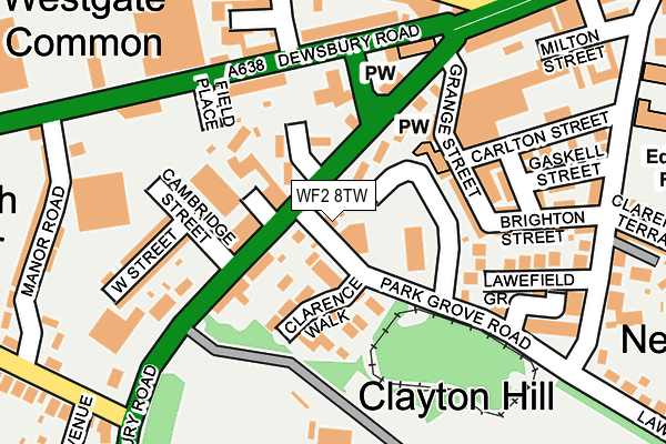
WF2 8TW lies on Parkgrove Road in Wakefield. WF2 8TW is located in the Wakefield West electoral ward, within the metropolitan district of Wakefield and the English Parliamentary constituency of Wakefield. The Sub Integrated Care Board (ICB) Location is NHS West Yorkshire ICB - 03R and the police force is West Yorkshire. This postcode has been in use since January 1980.


GetTheData
Source: OS OpenMap – Local (Ordnance Survey)
Source: OS VectorMap District (Ordnance Survey)
Licence: Open Government Licence (requires attribution)
| Easting | 432156 |
| Northing | 420250 |
| Latitude | 53.677732 |
| Longitude | -1.514681 |
GetTheData
Source: Open Postcode Geo
Licence: Open Government Licence
| Street | Parkgrove Road |
| Town/City | Wakefield |
| Country | England |
| Postcode District | WF2 |
➜ See where WF2 is on a map ➜ Where is Wakefield? | |
GetTheData
Source: Land Registry Price Paid Data
Licence: Open Government Licence
Elevation or altitude of WF2 8TW as distance above sea level:
| Metres | Feet | |
|---|---|---|
| Elevation | 30m | 98ft |
Elevation is measured from the approximate centre of the postcode, to the nearest point on an OS contour line from OS Terrain 50, which has contour spacing of ten vertical metres.
➜ How high above sea level am I? Find the elevation of your current position using your device's GPS.
GetTheData
Source: Open Postcode Elevation
Licence: Open Government Licence
| Ward | Wakefield West |
| Constituency | Wakefield |
GetTheData
Source: ONS Postcode Database
Licence: Open Government Licence
| Lawefield Lane Park Grove Rd (Horbury Road) | Flanshaw | 49m |
| Park Grove Rd Horbury Road (Park Grove Road) | Thornes | 50m |
| Horbury Road Cambridge St (Horbury Road) | Flanshaw | 73m |
| Park Grove Rd Horbury Road (Park Grove Road) | Thornes | 100m |
| Dewsbury Road Hanover St (Dewsbury Road) | Flanshaw | 166m |
| Wakefield Westgate Station | 0.8km |
| Wakefield Kirkgate Station | 1.7km |
| Sandal & Agbrigg Station | 2.7km |
GetTheData
Source: NaPTAN
Licence: Open Government Licence
| Percentage of properties with Next Generation Access | 100.0% |
| Percentage of properties with Superfast Broadband | 100.0% |
| Percentage of properties with Ultrafast Broadband | 100.0% |
| Percentage of properties with Full Fibre Broadband | 0.0% |
Superfast Broadband is between 30Mbps and 300Mbps
Ultrafast Broadband is > 300Mbps
| Percentage of properties unable to receive 2Mbps | 0.0% |
| Percentage of properties unable to receive 5Mbps | 0.0% |
| Percentage of properties unable to receive 10Mbps | 0.0% |
| Percentage of properties unable to receive 30Mbps | 0.0% |
GetTheData
Source: Ofcom
Licence: Ofcom Terms of Use (requires attribution)
GetTheData
Source: ONS Postcode Database
Licence: Open Government Licence


➜ Get more ratings from the Food Standards Agency
GetTheData
Source: Food Standards Agency
Licence: FSA terms & conditions
| Last Collection | |||
|---|---|---|---|
| Location | Mon-Fri | Sat | Distance |
| Ossett | 17:30 | 11:00 | 243m |
| 123 Lawefield Lane | 17:45 | 11:45 | 244m |
| Gill Syke Road | 17:30 | 11:00 | 274m |
GetTheData
Source: Dracos
Licence: Creative Commons Attribution-ShareAlike
| Risk of WF2 8TW flooding from rivers and sea | Very Low |
| ➜ WF2 8TW flood map | |
GetTheData
Source: Open Flood Risk by Postcode
Licence: Open Government Licence
The below table lists the International Territorial Level (ITL) codes (formerly Nomenclature of Territorial Units for Statistics (NUTS) codes) and Local Administrative Units (LAU) codes for WF2 8TW:
| ITL 1 Code | Name |
|---|---|
| TLE | Yorkshire and The Humber |
| ITL 2 Code | Name |
| TLE4 | West Yorkshire |
| ITL 3 Code | Name |
| TLE45 | Wakefield |
| LAU 1 Code | Name |
| E08000036 | Wakefield |
GetTheData
Source: ONS Postcode Directory
Licence: Open Government Licence
The below table lists the Census Output Area (OA), Lower Layer Super Output Area (LSOA), and Middle Layer Super Output Area (MSOA) for WF2 8TW:
| Code | Name | |
|---|---|---|
| OA | E00060009 | |
| LSOA | E01011907 | Wakefield 028D |
| MSOA | E02002465 | Wakefield 028 |
GetTheData
Source: ONS Postcode Directory
Licence: Open Government Licence
| WF2 8TU | Horbury Road | 70m |
| WF2 8TN | Horbury Road | 77m |
| WF2 8UD | Clarence Walk | 81m |
| WF2 8TT | St Michaels Close | 85m |
| WF2 8TY | Horbury Road | 88m |
| WF2 9BH | Field Place | 115m |
| WF2 8TF | Grange Street | 115m |
| WF2 8TZ | Cambridge Street | 131m |
| WF2 8TG | Grange Street | 142m |
| WF2 9RW | Horbury Road | 144m |
GetTheData
Source: Open Postcode Geo; Land Registry Price Paid Data
Licence: Open Government Licence