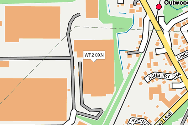
WF2 0XN is located in the Wrenthorpe and Outwood West electoral ward, within the metropolitan district of Wakefield and the English Parliamentary constituency of Morley and Outwood. The Sub Integrated Care Board (ICB) Location is NHS West Yorkshire ICB - 03R and the police force is West Yorkshire. This postcode has been in use since January 1993.


GetTheData
Source: OS OpenMap – Local (Ordnance Survey)
Source: OS VectorMap District (Ordnance Survey)
Licence: Open Government Licence (requires attribution)
| Easting | 432199 |
| Northing | 424235 |
| Latitude | 53.713546 |
| Longitude | -1.513617 |
GetTheData
Source: Open Postcode Geo
Licence: Open Government Licence
| Country | England |
| Postcode District | WF2 |
| ➜ WF2 open data dashboard ➜ See where WF2 is on a map ➜ Where is Wakefield? | |
GetTheData
Source: Land Registry Price Paid Data
Licence: Open Government Licence
Elevation or altitude of WF2 0XN as distance above sea level:
| Metres | Feet | |
|---|---|---|
| Elevation | 80m | 262ft |
Elevation is measured from the approximate centre of the postcode, to the nearest point on an OS contour line from OS Terrain 50, which has contour spacing of ten vertical metres.
➜ How high above sea level am I? Find the elevation of your current position using your device's GPS.
GetTheData
Source: Open Postcode Elevation
Licence: Open Government Licence
| Ward | Wrenthorpe And Outwood West |
| Constituency | Morley And Outwood |
GetTheData
Source: ONS Postcode Database
Licence: Open Government Licence
| September 2023 | Anti-social behaviour | On or near Kingsley Garth | 409m |
| July 2023 | Violence and sexual offences | On or near Kingsley Garth | 409m |
| July 2023 | Public order | On or near Kingsley Garth | 409m |
| ➜ Get more crime data in our Crime section | |||
GetTheData
Source: data.police.uk
Licence: Open Government Licence
| Lingwell Gate Lane Asbury Chase (Lingwell Gate Lane) | Outwood | 265m |
| Lingwell Gate Court (Lingwell Gate Lane) | Outwood | 279m |
| Lingwell Gate Ln Lingwell Gate Drive (Lingwell Gate Lane) | Outwood | 281m |
| Potovens Lane Ledger Ln (Potovens Lane) | Outwood | 282m |
| Potovens Lane Ledger Ln (Potovens Lane) | Outwood | 291m |
| Outwood Station | 0.3km |
| Wakefield Westgate Station | 3.4km |
| Wakefield Kirkgate Station | 4.2km |
GetTheData
Source: NaPTAN
Licence: Open Government Licence
GetTheData
Source: ONS Postcode Database
Licence: Open Government Licence


➜ Get more ratings from the Food Standards Agency
GetTheData
Source: Food Standards Agency
Licence: FSA terms & conditions
| Last Collection | |||
|---|---|---|---|
| Location | Mon-Fri | Sat | Distance |
| Farm Stores | 17:45 | 11:00 | 353m |
| Lawns Lane P.o. | 17:45 | 12:00 | 355m |
| Wakefield 41 Business Park | 18:30 | 504m | |
GetTheData
Source: Dracos
Licence: Creative Commons Attribution-ShareAlike
| Facility | Distance |
|---|---|
| Outwood Park Potovens Lane, Outwood, Wakefield Grass Pitches | 395m |
| Lofthouse Gate Wallace Gardens, Lofthouse Gate, Wakefield Grass Pitches | 515m |
| Outwood Grange Academy Potovens Lane, Outwood, Wakefield Health and Fitness Gym, Grass Pitches, Sports Hall, Artificial Grass Pitch, Studio | 655m |
GetTheData
Source: Active Places
Licence: Open Government Licence
| School | Phase of Education | Distance |
|---|---|---|
| Outwood Grange Academy Potovens Lane, Outwood, Wakefield, WF1 2PF | Secondary | 609m |
| Outwood Primary Academy Ledger Lane Ledger Lane, Outwood, Wakefield, WF1 2PH | Primary | 714m |
| Rooks Nest Academy Rooks Nest Road, Outwood, Wakefield, WF1 3DX | Primary | 1.2km |
GetTheData
Source: Edubase
Licence: Open Government Licence
The below table lists the International Territorial Level (ITL) codes (formerly Nomenclature of Territorial Units for Statistics (NUTS) codes) and Local Administrative Units (LAU) codes for WF2 0XN:
| ITL 1 Code | Name |
|---|---|
| TLE | Yorkshire and The Humber |
| ITL 2 Code | Name |
| TLE4 | West Yorkshire |
| ITL 3 Code | Name |
| TLE45 | Wakefield |
| LAU 1 Code | Name |
| E08000036 | Wakefield |
GetTheData
Source: ONS Postcode Directory
Licence: Open Government Licence
The below table lists the Census Output Area (OA), Lower Layer Super Output Area (LSOA), and Middle Layer Super Output Area (MSOA) for WF2 0XN:
| Code | Name | |
|---|---|---|
| OA | E00059952 | |
| LSOA | E01011893 | Wakefield 008C |
| MSOA | E02002445 | Wakefield 008 |
GetTheData
Source: ONS Postcode Directory
Licence: Open Government Licence
| WF1 2UH | Bramble Court | 184m |
| WF3 3JL | Lingwell Gate Lane | 197m |
| WF1 2PP | Ashbury Chase | 206m |
| WF3 3GZ | Bingham Place | 217m |
| WF3 3JP | Grandstand Road | 234m |
| WF1 2NX | Lingwell Gate Lane | 235m |
| WF1 2PG | Newstead Avenue | 245m |
| WF1 2NU | Lingwell Gate Lane | 288m |
| WF3 3HR | Lingwell Court | 302m |
| WF1 2PE | Potovens Lane | 303m |
GetTheData
Source: Open Postcode Geo; Land Registry Price Paid Data
Licence: Open Government Licence