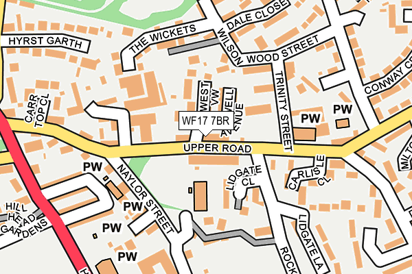
WF17 7BR is located in the Batley East electoral ward, within the metropolitan district of Kirklees and the English Parliamentary constituency of Batley and Spen. The Sub Integrated Care Board (ICB) Location is NHS West Yorkshire ICB - X2C4Y and the police force is West Yorkshire. This postcode has been in use since July 2013.


GetTheData
Source: OS OpenMap – Local (Ordnance Survey)
Source: OS VectorMap District (Ordnance Survey)
Licence: Open Government Licence (requires attribution)
| Easting | 423997 |
| Northing | 422823 |
| Latitude | 53.701309 |
| Longitude | -1.637998 |
GetTheData
Source: Open Postcode Geo
Licence: Open Government Licence
| Country | England |
| Postcode District | WF17 |
| ➜ WF17 open data dashboard ➜ See where WF17 is on a map ➜ Where is Batley? | |
GetTheData
Source: Land Registry Price Paid Data
Licence: Open Government Licence
Elevation or altitude of WF17 7BR as distance above sea level:
| Metres | Feet | |
|---|---|---|
| Elevation | 70m | 230ft |
Elevation is measured from the approximate centre of the postcode, to the nearest point on an OS contour line from OS Terrain 50, which has contour spacing of ten vertical metres.
➜ How high above sea level am I? Find the elevation of your current position using your device's GPS.
GetTheData
Source: Open Postcode Elevation
Licence: Open Government Licence
| Ward | Batley East |
| Constituency | Batley And Spen |
GetTheData
Source: ONS Postcode Database
Licence: Open Government Licence
| January 2024 | Violence and sexual offences | On or near Beckett Road | 158m |
| November 2023 | Violence and sexual offences | On or near Beckett Road | 158m |
| September 2023 | Vehicle crime | On or near Track Mount | 354m |
| ➜ Get more crime data in our Crime section | |||
GetTheData
Source: data.police.uk
Licence: Open Government Licence
| Hyrstlands Rd Town Street (Hyrstlands Road) | Batley Carr | 225m |
| Hyrstlands Rd Town Street (Hyrstlands Road) | Batley Carr | 238m |
| Hyrstlands Road Howard St (Hyrstlands Road) | Batley Carr | 264m |
| Hyrstlands Road Howard St (Hyrstlands Road) | Batley Carr | 274m |
| Halifax Rd Upper Road (Halifax Road) | Dewsbury | 276m |
| Dewsbury Station | 1.1km |
| Batley Station | 1.4km |
| Ravensthorpe Station | 3.1km |
GetTheData
Source: NaPTAN
Licence: Open Government Licence
| Percentage of properties with Next Generation Access | 100.0% |
| Percentage of properties with Superfast Broadband | 100.0% |
| Percentage of properties with Ultrafast Broadband | 0.0% |
| Percentage of properties with Full Fibre Broadband | 0.0% |
Superfast Broadband is between 30Mbps and 300Mbps
Ultrafast Broadband is > 300Mbps
| Percentage of properties unable to receive 2Mbps | 0.0% |
| Percentage of properties unable to receive 5Mbps | 0.0% |
| Percentage of properties unable to receive 10Mbps | 0.0% |
| Percentage of properties unable to receive 30Mbps | 0.0% |
GetTheData
Source: Ofcom
Licence: Ofcom Terms of Use (requires attribution)
GetTheData
Source: ONS Postcode Database
Licence: Open Government Licence


➜ Get more ratings from the Food Standards Agency
GetTheData
Source: Food Standards Agency
Licence: FSA terms & conditions
| Last Collection | |||
|---|---|---|---|
| Location | Mon-Fri | Sat | Distance |
| Naylor St | 17:30 | 11:00 | 141m |
| Carlisle Close / Upper Road | 17:30 | 11:00 | 181m |
| Longlands | 17:45 | 11:30 | 420m |
GetTheData
Source: Dracos
Licence: Creative Commons Attribution-ShareAlike
| Facility | Distance |
|---|---|
| Hyrstlands Park Park Close, Batley Grass Pitches | 315m |
| Halifax Road Recreation Ground Wheelwright Drive, Dewsbury Grass Pitches | 376m |
| Al-hikmah Sports Hall Track Road, Track Road, Batley Artificial Grass Pitch | 404m |
GetTheData
Source: Active Places
Licence: Open Government Licence
| School | Phase of Education | Distance |
|---|---|---|
| Carlton Junior and Infant School Upper Road, Batley Carr, Dewsbury, WF13 2DQ | Primary | 71m |
| Warwick Road Primary School Warwick Road, Batley, WF17 6BS | Primary | 474m |
| The Branch Christian School Dewsbury Gospel Church, West Park Street, Dewsbury, WF13 4LA | Not applicable | 496m |
GetTheData
Source: Edubase
Licence: Open Government Licence
The below table lists the International Territorial Level (ITL) codes (formerly Nomenclature of Territorial Units for Statistics (NUTS) codes) and Local Administrative Units (LAU) codes for WF17 7BR:
| ITL 1 Code | Name |
|---|---|
| TLE | Yorkshire and The Humber |
| ITL 2 Code | Name |
| TLE4 | West Yorkshire |
| ITL 3 Code | Name |
| TLE44 | Calderdale and Kirklees |
| LAU 1 Code | Name |
| E08000034 | Kirklees |
GetTheData
Source: ONS Postcode Directory
Licence: Open Government Licence
The below table lists the Census Output Area (OA), Lower Layer Super Output Area (LSOA), and Middle Layer Super Output Area (MSOA) for WF17 7BR:
| Code | Name | |
|---|---|---|
| OA | E00055563 | |
| LSOA | E01011020 | Kirklees 013E |
| MSOA | E02002283 | Kirklees 013 |
GetTheData
Source: ONS Postcode Directory
Licence: Open Government Licence
| WF13 2DQ | Upper Road | 35m |
| WF17 7LR | Upper Road | 41m |
| WF17 7LL | West View | 54m |
| WF17 7LJ | Maxwell Avenue | 54m |
| WF13 2DP | Lidgate Close | 96m |
| WF17 7LT | Upper Road | 97m |
| WF17 7JZ | Trinity Street | 121m |
| WF13 2DE | Trinity Mount | 124m |
| WF13 2DJ | Upper Road | 129m |
| WF17 7LN | Pickles Street | 134m |
GetTheData
Source: Open Postcode Geo; Land Registry Price Paid Data
Licence: Open Government Licence