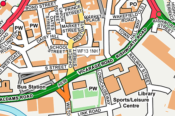
WF13 1NH is located in the Dewsbury East electoral ward, within the metropolitan district of Kirklees and the English Parliamentary constituency of Dewsbury. The Sub Integrated Care Board (ICB) Location is NHS West Yorkshire ICB - X2C4Y and the police force is West Yorkshire. This postcode has been in use since July 1986.


GetTheData
Source: OS OpenMap – Local (Ordnance Survey)
Source: OS VectorMap District (Ordnance Survey)
Licence: Open Government Licence (requires attribution)
| Easting | 424615 |
| Northing | 421618 |
| Latitude | 53.690450 |
| Longitude | -1.628733 |
GetTheData
Source: Open Postcode Geo
Licence: Open Government Licence
| Country | England |
| Postcode District | WF13 |
| ➜ WF13 open data dashboard ➜ See where WF13 is on a map ➜ Where is Dewsbury? | |
GetTheData
Source: Land Registry Price Paid Data
Licence: Open Government Licence
Elevation or altitude of WF13 1NH as distance above sea level:
| Metres | Feet | |
|---|---|---|
| Elevation | 40m | 131ft |
Elevation is measured from the approximate centre of the postcode, to the nearest point on an OS contour line from OS Terrain 50, which has contour spacing of ten vertical metres.
➜ How high above sea level am I? Find the elevation of your current position using your device's GPS.
GetTheData
Source: Open Postcode Elevation
Licence: Open Government Licence
| Ward | Dewsbury East |
| Constituency | Dewsbury |
GetTheData
Source: ONS Postcode Database
Licence: Open Government Licence
| January 2024 | Anti-social behaviour | On or near Daisy Hill | 159m |
| January 2024 | Drugs | On or near Daisy Hill | 159m |
| January 2024 | Violence and sexual offences | On or near Daisy Hill | 159m |
| ➜ Get more crime data in our Crime section | |||
GetTheData
Source: data.police.uk
Licence: Open Government Licence
| Church Street Tithe Barn St (Church Street) | Dewsbury | 67m |
| Longcauseway | Dewsbury | 98m |
| Longcauseway | Dewsbury | 116m |
| Northgate Market Place (Northgate) | Dewsbury | 154m |
| Railway St Rishworth Road (Railway Street) | Dewsbury | 190m |
| Dewsbury Station | 0.3km |
| Batley Station | 2.2km |
| Ravensthorpe Station | 2.4km |
GetTheData
Source: NaPTAN
Licence: Open Government Licence
| Median download speed | 13.4Mbps |
| Average download speed | 23.7Mbps |
| Maximum download speed | 80.00Mbps |
| Median upload speed | 0.9Mbps |
| Average upload speed | 4.0Mbps |
| Maximum upload speed | 20.00Mbps |
GetTheData
Source: Ofcom
Licence: Ofcom Terms of Use (requires attribution)
Estimated total energy consumption in WF13 1NH by fuel type, 2015.
| Consumption (kWh) | 66,777 |
|---|---|
| Meter count | 6 |
| Mean (kWh/meter) | 11,129 |
| Median (kWh/meter) | 4,420 |
GetTheData
Source: Postcode level gas estimates: 2015 (experimental)
Source: Postcode level electricity estimates: 2015 (experimental)
Licence: Open Government Licence
GetTheData
Source: ONS Postcode Database
Licence: Open Government Licence


➜ Get more ratings from the Food Standards Agency
GetTheData
Source: Food Standards Agency
Licence: FSA terms & conditions
| Last Collection | |||
|---|---|---|---|
| Location | Mon-Fri | Sat | Distance |
| Church Street | 18:30 | 12:15 | 73m |
| Market House Pub Church St | 18:30 | 12:15 | 73m |
| 7 Westgate | 18:30 | 12:15 | 93m |
GetTheData
Source: Dracos
Licence: Creative Commons Attribution-ShareAlike
| Facility | Distance |
|---|---|
| Ladies Leisure Ltd (Closed) South Street, Dewsbury Health and Fitness Gym, Studio | 124m |
| Dewsbury Sports Centre Longcauseway, Dewsbury Sports Hall, Swimming Pool, Health and Fitness Gym, Studio, Squash Courts | 124m |
| Crawford Ashley Fitness Centre (Closed) Union Street, Dewsbury Health and Fitness Gym | 150m |
GetTheData
Source: Active Places
Licence: Open Government Licence
| School | Phase of Education | Distance |
|---|---|---|
| Eastborough Junior Infant and Nursery School Rockley Street, Dewsbury, WF13 1NS | Primary | 375m |
| Eastborough Junior Infant and Nursery School Rockley Street, Dewsbury, WF13 1NS | Primary | 375m |
| Flatts Nursery School Ashworth Green, Dewsbury, WF13 2SU | Nursery | 676m |
GetTheData
Source: Edubase
Licence: Open Government Licence
The below table lists the International Territorial Level (ITL) codes (formerly Nomenclature of Territorial Units for Statistics (NUTS) codes) and Local Administrative Units (LAU) codes for WF13 1NH:
| ITL 1 Code | Name |
|---|---|
| TLE | Yorkshire and The Humber |
| ITL 2 Code | Name |
| TLE4 | West Yorkshire |
| ITL 3 Code | Name |
| TLE44 | Calderdale and Kirklees |
| LAU 1 Code | Name |
| E08000034 | Kirklees |
GetTheData
Source: ONS Postcode Directory
Licence: Open Government Licence
The below table lists the Census Output Area (OA), Lower Layer Super Output Area (LSOA), and Middle Layer Super Output Area (MSOA) for WF13 1NH:
| Code | Name | |
|---|---|---|
| OA | E00175513 | |
| LSOA | E01011130 | Kirklees 017B |
| MSOA | E02002287 | Kirklees 017 |
GetTheData
Source: ONS Postcode Directory
Licence: Open Government Licence
| WF12 8EN | Longcauseway | 54m |
| WF13 1JH | Westgate | 64m |
| WF13 1BL | Westgate | 89m |
| WF13 1JX | Church Street | 92m |
| WF13 1BW | Westgate | 94m |
| WF13 1JF | Westgate | 96m |
| WF13 1LH | Daisy Hill | 128m |
| WF13 1DL | Market Place | 128m |
| WF13 1DQ | Market Place | 131m |
| WF13 1DW | Market Place | 132m |
GetTheData
Source: Open Postcode Geo; Land Registry Price Paid Data
Licence: Open Government Licence