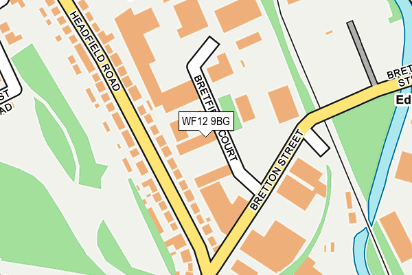
WF12 9BG is located in the Dewsbury South electoral ward, within the metropolitan district of Kirklees and the English Parliamentary constituency of Dewsbury. The Sub Integrated Care Board (ICB) Location is NHS West Yorkshire ICB - X2C4Y and the police force is West Yorkshire. This postcode has been in use since January 1993.


GetTheData
Source: OS OpenMap – Local (Ordnance Survey)
Source: OS VectorMap District (Ordnance Survey)
Licence: Open Government Licence (requires attribution)
| Easting | 424767 |
| Northing | 420218 |
| Latitude | 53.677860 |
| Longitude | -1.626543 |
GetTheData
Source: Open Postcode Geo
Licence: Open Government Licence
| Country | England |
| Postcode District | WF12 |
| ➜ WF12 open data dashboard ➜ See where WF12 is on a map ➜ Where is Dewsbury? | |
GetTheData
Source: Land Registry Price Paid Data
Licence: Open Government Licence
Elevation or altitude of WF12 9BG as distance above sea level:
| Metres | Feet | |
|---|---|---|
| Elevation | 50m | 164ft |
Elevation is measured from the approximate centre of the postcode, to the nearest point on an OS contour line from OS Terrain 50, which has contour spacing of ten vertical metres.
➜ How high above sea level am I? Find the elevation of your current position using your device's GPS.
GetTheData
Source: Open Postcode Elevation
Licence: Open Government Licence
| Ward | Dewsbury South |
| Constituency | Dewsbury |
GetTheData
Source: ONS Postcode Database
Licence: Open Government Licence
| January 2024 | Violence and sexual offences | On or near Thornie View | 498m |
| January 2024 | Vehicle crime | On or near Thornie View | 498m |
| January 2024 | Other crime | On or near Thornie View | 498m |
| ➜ Get more crime data in our Crime section | |||
GetTheData
Source: data.police.uk
Licence: Open Government Licence
| Headfield Road | Thornhill Lees | 126m |
| Headfield Rd Bretton Street (Headfield Road) | Thornhill Lees | 137m |
| Headfield Rd Bretton Street (Headfield Road) | Thornhill Lees | 143m |
| Headfield Road Bretton St (Headfield Road) | Thornhill Lees | 157m |
| Headfield Road Headfield View (Headfield Road) | Thornhill Lees | 342m |
| Dewsbury Station | 1.6km |
| Ravensthorpe Station | 1.9km |
| Batley Station | 3.6km |
GetTheData
Source: NaPTAN
Licence: Open Government Licence
GetTheData
Source: ONS Postcode Database
Licence: Open Government Licence


➜ Get more ratings from the Food Standards Agency
GetTheData
Source: Food Standards Agency
Licence: FSA terms & conditions
| Last Collection | |||
|---|---|---|---|
| Location | Mon-Fri | Sat | Distance |
| 184 Headfield Road | 17:45 | 12:00 | 157m |
| South St/Pentland Road | 17:45 | 12:15 | 408m |
| Hebble Mills | 17:30 | 11:15 | 596m |
GetTheData
Source: Dracos
Licence: Creative Commons Attribution-ShareAlike
| Facility | Distance |
|---|---|
| Institute Of Islamic Education South Street, Savile Town, Dewsbury Sports Hall | 448m |
| Madni Muslim Girl's High School Scarborough Street, Dewsbury Sports Hall | 549m |
| Sands Lane Playing Fields Sands Road, Earlsheaton, Dewsbury Grass Pitches | 713m |
GetTheData
Source: Active Places
Licence: Open Government Licence
| School | Phase of Education | Distance |
|---|---|---|
| Pentland Infant and Nursery School Pentland Road, Savile Town, Dewsbury, WF12 9JR | Primary | 300m |
| Paradise Primary School 1 Bretton Street, Dewsbury, WF12 9BB | Not applicable | 328m |
| Headfield Church of England Voluntary Controlled Junior School Vicarage Road, Thornhill Lees, Headfield Junior School, Dewsbury, WF12 9PD | Primary | 458m |
GetTheData
Source: Edubase
Licence: Open Government Licence
The below table lists the International Territorial Level (ITL) codes (formerly Nomenclature of Territorial Units for Statistics (NUTS) codes) and Local Administrative Units (LAU) codes for WF12 9BG:
| ITL 1 Code | Name |
|---|---|
| TLE | Yorkshire and The Humber |
| ITL 2 Code | Name |
| TLE4 | West Yorkshire |
| ITL 3 Code | Name |
| TLE44 | Calderdale and Kirklees |
| LAU 1 Code | Name |
| E08000034 | Kirklees |
GetTheData
Source: ONS Postcode Directory
Licence: Open Government Licence
The below table lists the Census Output Area (OA), Lower Layer Super Output Area (LSOA), and Middle Layer Super Output Area (MSOA) for WF12 9BG:
| Code | Name | |
|---|---|---|
| OA | E00056719 | |
| LSOA | E01011263 | Kirklees 024F |
| MSOA | E02002294 | Kirklees 024 |
GetTheData
Source: ONS Postcode Directory
Licence: Open Government Licence
| WF12 9JJ | Headfield Road | 97m |
| WF12 9JH | Headfield Road | 109m |
| WF12 9JQ | Headfield Road | 246m |
| WF12 9JG | Headfield Road | 249m |
| WF12 9NX | Hillcrest Road | 303m |
| WF12 9JL | Headfield Road | 326m |
| WF12 9BB | Bretton Street | 328m |
| WF12 9JW | Ashfield | 372m |
| WF12 9DA | Churchbank Way | 378m |
| WF12 9JP | Headfield View | 406m |
GetTheData
Source: Open Postcode Geo; Land Registry Price Paid Data
Licence: Open Government Licence