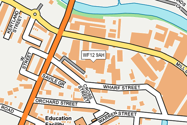
WF12 9AH is located in the Dewsbury South electoral ward, within the metropolitan district of Kirklees and the English Parliamentary constituency of Dewsbury. The Sub Integrated Care Board (ICB) Location is NHS West Yorkshire ICB - X2C4Y and the police force is West Yorkshire. This postcode has been in use since January 1980.


GetTheData
Source: OS OpenMap – Local (Ordnance Survey)
Source: OS VectorMap District (Ordnance Survey)
Licence: Open Government Licence (requires attribution)
| Easting | 424669 |
| Northing | 421110 |
| Latitude | 53.685882 |
| Longitude | -1.627956 |
GetTheData
Source: Open Postcode Geo
Licence: Open Government Licence
| Country | England |
| Postcode District | WF12 |
➜ See where WF12 is on a map ➜ Where is Dewsbury? | |
GetTheData
Source: Land Registry Price Paid Data
Licence: Open Government Licence
Elevation or altitude of WF12 9AH as distance above sea level:
| Metres | Feet | |
|---|---|---|
| Elevation | 40m | 131ft |
Elevation is measured from the approximate centre of the postcode, to the nearest point on an OS contour line from OS Terrain 50, which has contour spacing of ten vertical metres.
➜ How high above sea level am I? Find the elevation of your current position using your device's GPS.
GetTheData
Source: Open Postcode Elevation
Licence: Open Government Licence
| Ward | Dewsbury South |
| Constituency | Dewsbury |
GetTheData
Source: ONS Postcode Database
Licence: Open Government Licence
| Savile Rd Mill Street East (Savile Road) | Savile Town | 179m |
| Warren Street Thornhill St (Warren Street) | Savile Town | 187m |
| Warren Street Thornhill St (Warren Street) | Savile Town | 192m |
| Savile Rd Mill Street West (Savile Road) | Savile Town | 195m |
| Warren Street Wharf St (Warren Street) | Savile Town | 210m |
| Dewsbury Station | 0.8km |
| Ravensthorpe Station | 2.2km |
| Batley Station | 2.7km |
GetTheData
Source: NaPTAN
Licence: Open Government Licence
GetTheData
Source: ONS Postcode Database
Licence: Open Government Licence


➜ Get more ratings from the Food Standards Agency
GetTheData
Source: Food Standards Agency
Licence: FSA terms & conditions
| Last Collection | |||
|---|---|---|---|
| Location | Mon-Fri | Sat | Distance |
| Savilletown P.o. | 17:45 | 11:45 | 217m |
| 84 Saville Road | 17:45 | 12:15 | 287m |
| Mill Street East | 17:45 | 11:45 | 319m |
GetTheData
Source: Dracos
Licence: Creative Commons Attribution-ShareAlike
| Risk of WF12 9AH flooding from rivers and sea | Low |
| ➜ WF12 9AH flood map | |
GetTheData
Source: Open Flood Risk by Postcode
Licence: Open Government Licence
The below table lists the International Territorial Level (ITL) codes (formerly Nomenclature of Territorial Units for Statistics (NUTS) codes) and Local Administrative Units (LAU) codes for WF12 9AH:
| ITL 1 Code | Name |
|---|---|
| TLE | Yorkshire and The Humber |
| ITL 2 Code | Name |
| TLE4 | West Yorkshire |
| ITL 3 Code | Name |
| TLE44 | Calderdale and Kirklees |
| LAU 1 Code | Name |
| E08000034 | Kirklees |
GetTheData
Source: ONS Postcode Directory
Licence: Open Government Licence
The below table lists the Census Output Area (OA), Lower Layer Super Output Area (LSOA), and Middle Layer Super Output Area (MSOA) for WF12 9AH:
| Code | Name | |
|---|---|---|
| OA | E00056721 | |
| LSOA | E01011257 | Kirklees 024A |
| MSOA | E02002294 | Kirklees 024 |
GetTheData
Source: ONS Postcode Directory
Licence: Open Government Licence
| WF12 9AU | Wharf Street | 83m |
| WF12 9LH | Orchard Street | 116m |
| WF12 9AT | Wharf Street | 138m |
| WF12 9LZ | Kaye Street | 156m |
| WF12 9AS | Warren Street | 156m |
| WF12 9PN | Savile Grove | 165m |
| WF12 9LS | Orchard Street | 186m |
| WF12 9LY | Warren Street | 194m |
| WF12 9JS | Thornhill Street | 218m |
| WF12 9PJ | Savile Road | 219m |
GetTheData
Source: Open Postcode Geo; Land Registry Price Paid Data
Licence: Open Government Licence