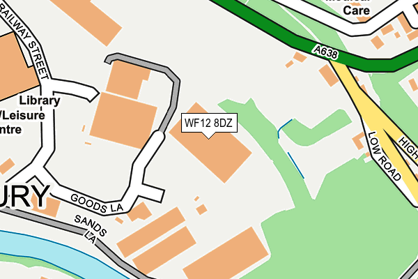
WF12 8DZ is located in the Dewsbury East electoral ward, within the metropolitan district of Kirklees and the English Parliamentary constituency of Dewsbury. The Sub Integrated Care Board (ICB) Location is NHS West Yorkshire ICB - X2C4Y and the police force is West Yorkshire. This postcode has been in use since December 1995.


GetTheData
Source: OS OpenMap – Local (Ordnance Survey)
Source: OS VectorMap District (Ordnance Survey)
Licence: Open Government Licence (requires attribution)
| Easting | 425061 |
| Northing | 421439 |
| Latitude | 53.688821 |
| Longitude | -1.621994 |
GetTheData
Source: Open Postcode Geo
Licence: Open Government Licence
| Country | England |
| Postcode District | WF12 |
| ➜ WF12 open data dashboard ➜ See where WF12 is on a map ➜ Where is Dewsbury? | |
GetTheData
Source: Land Registry Price Paid Data
Licence: Open Government Licence
Elevation or altitude of WF12 8DZ as distance above sea level:
| Metres | Feet | |
|---|---|---|
| Elevation | 40m | 131ft |
Elevation is measured from the approximate centre of the postcode, to the nearest point on an OS contour line from OS Terrain 50, which has contour spacing of ten vertical metres.
➜ How high above sea level am I? Find the elevation of your current position using your device's GPS.
GetTheData
Source: Open Postcode Elevation
Licence: Open Government Licence
| Ward | Dewsbury East |
| Constituency | Dewsbury |
GetTheData
Source: ONS Postcode Database
Licence: Open Government Licence
| June 2022 | Public order | On or near Petrol Station | 118m |
| June 2022 | Shoplifting | On or near Petrol Station | 118m |
| June 2022 | Shoplifting | On or near Petrol Station | 118m |
| ➜ Get more crime data in our Crime section | |||
GetTheData
Source: data.police.uk
Licence: Open Government Licence
| Railway Street Sainsburys (Access Road - On Railway Street) | Dewsbury | 174m |
| Wakefield Rd High Road (Wakefield Road) | Earlsheaton | 182m |
| Wakefield Rd High Road (Wakefield Road) | Earlsheaton | 195m |
| High Road Wakefield Rd (High Road) | Earlsheaton | 220m |
| Railway St Rishworth Road (Railway Street) | Dewsbury | 299m |
| Dewsbury Station | 0.8km |
| Batley Station | 2.4km |
| Ravensthorpe Station | 2.7km |
GetTheData
Source: NaPTAN
Licence: Open Government Licence
GetTheData
Source: ONS Postcode Database
Licence: Open Government Licence


➜ Get more ratings from the Food Standards Agency
GetTheData
Source: Food Standards Agency
Licence: FSA terms & conditions
| Last Collection | |||
|---|---|---|---|
| Location | Mon-Fri | Sat | Distance |
| 7 High Road / Low Road | 16:30 | 11:15 | 226m |
| Mill Street East | 17:45 | 11:45 | 431m |
| Dewsbury Post Office | 17:15 | 12:30 | 468m |
GetTheData
Source: Dracos
Licence: Creative Commons Attribution-ShareAlike
| Facility | Distance |
|---|---|
| Dewsbury Sports Centre Longcauseway, Dewsbury Sports Hall, Swimming Pool, Health and Fitness Gym, Studio, Squash Courts | 375m |
| Kick Off Dewsbury Mill Street East, Dewsbury Artificial Grass Pitch, Sports Hall | 546m |
| Earlsheaton Park Cross Park Street, Earlsheaton, Dewsbury Grass Pitches | 556m |
GetTheData
Source: Active Places
Licence: Open Government Licence
| School | Phase of Education | Distance |
|---|---|---|
| Eastborough Junior Infant and Nursery School Rockley Street, Dewsbury, WF13 1NS | Primary | 543m |
| Eastborough Junior Infant and Nursery School Rockley Street, Dewsbury, WF13 1NS | Primary | 543m |
| Savile Town Church of England Voluntary Controlled Infant and Nursery School Warren Street, Savile Town, Dewsbury, WF12 9LY | Primary | 703m |
GetTheData
Source: Edubase
Licence: Open Government Licence
The below table lists the International Territorial Level (ITL) codes (formerly Nomenclature of Territorial Units for Statistics (NUTS) codes) and Local Administrative Units (LAU) codes for WF12 8DZ:
| ITL 1 Code | Name |
|---|---|
| TLE | Yorkshire and The Humber |
| ITL 2 Code | Name |
| TLE4 | West Yorkshire |
| ITL 3 Code | Name |
| TLE44 | Calderdale and Kirklees |
| LAU 1 Code | Name |
| E08000034 | Kirklees |
GetTheData
Source: ONS Postcode Directory
Licence: Open Government Licence
The below table lists the Census Output Area (OA), Lower Layer Super Output Area (LSOA), and Middle Layer Super Output Area (MSOA) for WF12 8DZ:
| Code | Name | |
|---|---|---|
| OA | E00056064 | |
| LSOA | E01011123 | Kirklees 018C |
| MSOA | E02002288 | Kirklees 018 |
GetTheData
Source: ONS Postcode Directory
Licence: Open Government Licence
| WF12 8EH | Sands Lane | 158m |
| WF12 8AX | Wakefield Road | 172m |
| WF12 8BZ | Low Road | 208m |
| WF12 8AZ | High Road | 232m |
| WF12 7DA | Old Bank Road | 259m |
| WF12 8AU | Wakefield Road | 266m |
| WF12 8BS | Middle Road | 277m |
| WF12 7AW | Pennine Road | 325m |
| WF12 7DF | Bank Street | 335m |
| WF12 8BA | Mount Pleasant | 335m |
GetTheData
Source: Open Postcode Geo; Land Registry Price Paid Data
Licence: Open Government Licence