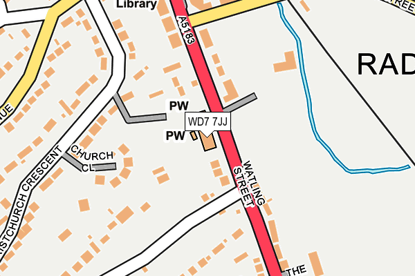
WD7 7JJ is located in the Aldenham East electoral ward, within the local authority district of Hertsmere and the English Parliamentary constituency of Hertsmere. The Sub Integrated Care Board (ICB) Location is NHS Hertfordshire and West Essex ICB - 06N and the police force is Hertfordshire. This postcode has been in use since January 1980.


GetTheData
Source: OS OpenMap – Local (Ordnance Survey)
Source: OS VectorMap District (Ordnance Survey)
Licence: Open Government Licence (requires attribution)
| Easting | 516550 |
| Northing | 199256 |
| Latitude | 51.679984 |
| Longitude | -0.315657 |
GetTheData
Source: Open Postcode Geo
Licence: Open Government Licence
| Country | England |
| Postcode District | WD7 |
| ➜ WD7 open data dashboard ➜ See where WD7 is on a map ➜ Where is Radlett? | |
GetTheData
Source: Land Registry Price Paid Data
Licence: Open Government Licence
Elevation or altitude of WD7 7JJ as distance above sea level:
| Metres | Feet | |
|---|---|---|
| Elevation | 80m | 262ft |
Elevation is measured from the approximate centre of the postcode, to the nearest point on an OS contour line from OS Terrain 50, which has contour spacing of ten vertical metres.
➜ How high above sea level am I? Find the elevation of your current position using your device's GPS.
GetTheData
Source: Open Postcode Elevation
Licence: Open Government Licence
| Ward | Aldenham East |
| Constituency | Hertsmere |
GetTheData
Source: ONS Postcode Database
Licence: Open Government Licence
| June 2022 | Violence and sexual offences | On or near Athlone Close | 93m |
| June 2022 | Anti-social behaviour | On or near Athlone Close | 93m |
| June 2022 | Violence and sexual offences | On or near Watling Street | 123m |
| ➜ Get more crime data in our Crime section | |||
GetTheData
Source: data.police.uk
Licence: Open Government Licence
| Post Office (Watling Street) | Radlett | 339m |
| Craigweil Avenue (Theobald Street) | Radlett | 341m |
| Craigweil Avenue (Theobald Street) | Radlett | 345m |
| Post Office (Watling Street) | Radlett | 350m |
| Red Lion Hotel (Aldenham Road) | Radlett | 536m |
| Radlett Station | 0.6km |
| Elstree & Borehamwood Station | 3.9km |
| Bricket Wood Station | 4.1km |
GetTheData
Source: NaPTAN
Licence: Open Government Licence
GetTheData
Source: ONS Postcode Database
Licence: Open Government Licence

➜ Get more ratings from the Food Standards Agency
GetTheData
Source: Food Standards Agency
Licence: FSA terms & conditions
| Last Collection | |||
|---|---|---|---|
| Location | Mon-Fri | Sat | Distance |
| Aldenham Avenue North | 17:15 | 12:00 | 283m |
| Radlett Sorting Office | 17:45 | 11:30 | 343m |
| Scrubbitts Square | 17:15 | 11:45 | 546m |
GetTheData
Source: Dracos
Licence: Creative Commons Attribution-ShareAlike
| Facility | Distance |
|---|---|
| Radlett Lawn Tennis And Squash Club Watling Street, Radlett Squash Courts, Outdoor Tennis Courts | 152m |
| Tabard Rfc Cobden Hill, Radlett Grass Pitches, Health and Fitness Gym | 518m |
| Radlett Cricket Club Cobden Hill, Radlett Grass Pitches, Health and Fitness Gym | 550m |
GetTheData
Source: Active Places
Licence: Open Government Licence
| School | Phase of Education | Distance |
|---|---|---|
| Newberries Primary School Newberries Avenue, Radlett, WD7 7EL | Primary | 601m |
| St John's Church of England Infant and Nursery School Gills Hill Lane, Radlett, WD7 8DD | Primary | 863m |
| Fair Field Junior School Watford Road, Radlett, Radlett, WD7 8LU | Primary | 1.3km |
GetTheData
Source: Edubase
Licence: Open Government Licence
The below table lists the International Territorial Level (ITL) codes (formerly Nomenclature of Territorial Units for Statistics (NUTS) codes) and Local Administrative Units (LAU) codes for WD7 7JJ:
| ITL 1 Code | Name |
|---|---|
| TLH | East |
| ITL 2 Code | Name |
| TLH2 | Bedfordshire and Hertfordshire |
| ITL 3 Code | Name |
| TLH23 | Hertfordshire CC |
| LAU 1 Code | Name |
| E07000098 | Hertsmere |
GetTheData
Source: ONS Postcode Directory
Licence: Open Government Licence
The below table lists the Census Output Area (OA), Lower Layer Super Output Area (LSOA), and Middle Layer Super Output Area (MSOA) for WD7 7JJ:
| Code | Name | |
|---|---|---|
| OA | E00119481 | |
| LSOA | E01023525 | Hertsmere 005C |
| MSOA | E02004900 | Hertsmere 005 |
GetTheData
Source: ONS Postcode Directory
Licence: Open Government Licence
| WD7 7JG | Watling Street | 75m |
| WD7 7JF | Athlone Close | 99m |
| WD7 8BJ | Church Close | 128m |
| WD7 7JH | Watling Street | 157m |
| WD7 8AG | Christchurch Crescent | 174m |
| WD7 7NA | Watling Street | 197m |
| WD7 8AH | Christchurch Crescent | 198m |
| WD7 7JP | Cobden Hill | 204m |
| WD7 8AD | Loom Lane | 208m |
| WD7 7JL | Cobden Hill | 234m |
GetTheData
Source: Open Postcode Geo; Land Registry Price Paid Data
Licence: Open Government Licence