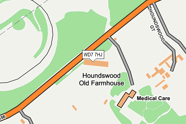
WD7 7HJ is located in the Park Street electoral ward, within the local authority district of St Albans and the English Parliamentary constituency of St Albans. The Sub Integrated Care Board (ICB) Location is NHS Hertfordshire and West Essex ICB - 06N and the police force is Hertfordshire. This postcode has been in use since December 1996.


GetTheData
Source: OS OpenMap – Local (Ordnance Survey)
Source: OS VectorMap District (Ordnance Survey)
Licence: Open Government Licence (requires attribution)
| Easting | 516262 |
| Northing | 201504 |
| Latitude | 51.700247 |
| Longitude | -0.319073 |
GetTheData
Source: Open Postcode Geo
Licence: Open Government Licence
| Country | England |
| Postcode District | WD7 |
| ➜ WD7 open data dashboard ➜ See where WD7 is on a map | |
GetTheData
Source: Land Registry Price Paid Data
Licence: Open Government Licence
Elevation or altitude of WD7 7HJ as distance above sea level:
| Metres | Feet | |
|---|---|---|
| Elevation | 90m | 295ft |
Elevation is measured from the approximate centre of the postcode, to the nearest point on an OS contour line from OS Terrain 50, which has contour spacing of ten vertical metres.
➜ How high above sea level am I? Find the elevation of your current position using your device's GPS.
GetTheData
Source: Open Postcode Elevation
Licence: Open Government Licence
| Ward | Park Street |
| Constituency | St Albans |
GetTheData
Source: ONS Postcode Database
Licence: Open Government Licence
| June 2022 | Other theft | On or near Houndswood Gate | 236m |
| June 2022 | Other theft | On or near Harper Lane | 289m |
| June 2022 | Other crime | On or near Harper Lane | 289m |
| ➜ Get more crime data in our Crime section | |||
GetTheData
Source: data.police.uk
Licence: Open Government Licence
| Hill Farm (Watling Street) | Radlett | 520m |
| Hill Farm (Watling Street) | Radlett | 549m |
| Bridgefoot Cottages (Radlett Road) | Colney Street | 573m |
| Bridgefoot Cottages (Radlett Road) | Colney Street | 635m |
| Kitswell Way (Watling Street) | Radlett | 785m |
| Radlett Station | 1.7km |
| How Wood (Herts) Station | 2.6km |
| Bricket Wood Station | 2.8km |
GetTheData
Source: NaPTAN
Licence: Open Government Licence
GetTheData
Source: ONS Postcode Database
Licence: Open Government Licence


➜ Get more ratings from the Food Standards Agency
GetTheData
Source: Food Standards Agency
Licence: FSA terms & conditions
| Last Collection | |||
|---|---|---|---|
| Location | Mon-Fri | Sat | Distance |
| Oakridge Avenue | 17:15 | 11:45 | 809m |
| Goodyers Avenue | 17:30 | 11:45 | 1,178m |
| Station Road | 17:15 | 11:45 | 1,621m |
GetTheData
Source: Dracos
Licence: Creative Commons Attribution-ShareAlike
| Facility | Distance |
|---|---|
| Radlett Golf Centre - Simon Garner Golf Academy Harpur Lane, Radlett Golf | 60m |
| Harperbury Hospital (Closed) Harper Lane, Shenley , Radlett Grass Pitches | 1.2km |
| Athletic Squared (Closed) Watling Street, Radlett Health and Fitness Gym, Studio | 1.5km |
GetTheData
Source: Active Places
Licence: Open Government Licence
| School | Phase of Education | Distance |
|---|---|---|
| Radlett Lodge School Harper Lane, Radlett, WD7 9HW | Not applicable | 786m |
| St John's Church of England Infant and Nursery School Gills Hill Lane, Radlett, WD7 8DD | Primary | 2km |
| Clore Shalom School Hugo Gryn Way, Shenley, WD7 9BL | Primary | 2.1km |
GetTheData
Source: Edubase
Licence: Open Government Licence
The below table lists the International Territorial Level (ITL) codes (formerly Nomenclature of Territorial Units for Statistics (NUTS) codes) and Local Administrative Units (LAU) codes for WD7 7HJ:
| ITL 1 Code | Name |
|---|---|
| TLH | East |
| ITL 2 Code | Name |
| TLH2 | Bedfordshire and Hertfordshire |
| ITL 3 Code | Name |
| TLH23 | Hertfordshire CC |
| LAU 1 Code | Name |
| E07000240 | St Albans |
GetTheData
Source: ONS Postcode Directory
Licence: Open Government Licence
The below table lists the Census Output Area (OA), Lower Layer Super Output Area (LSOA), and Middle Layer Super Output Area (MSOA) for WD7 7HJ:
| Code | Name | |
|---|---|---|
| OA | E00120446 | |
| LSOA | E01023720 | St Albans 019C |
| MSOA | E02004942 | St Albans 019 |
GetTheData
Source: ONS Postcode Directory
Licence: Open Government Licence
| WD7 7HU | Harper Lane | 262m |
| WD7 7HT | Watling Street | 529m |
| WD7 7HY | Harper Lane | 540m |
| AL2 2EJ | Radlett Road | 586m |
| WD7 7HW | Watling Knoll | 671m |
| WD7 7HS | Watling Street | 708m |
| WD7 8HA | The Close | 741m |
| WD7 7DF | The Heath | 763m |
| WD7 7FD | Paddock View | 772m |
| WD7 8HB | Oakridge Avenue | 780m |
GetTheData
Source: Open Postcode Geo; Land Registry Price Paid Data
Licence: Open Government Licence