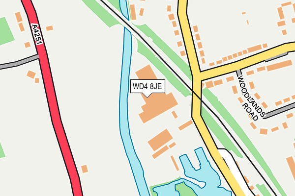
WD4 8JE is located in the Gade Valley electoral ward, within the local authority district of Three Rivers and the English Parliamentary constituency of St Albans. The Sub Integrated Care Board (ICB) Location is NHS Hertfordshire and West Essex ICB - 06N and the police force is Hertfordshire. This postcode has been in use since January 1980.


GetTheData
Source: OS OpenMap – Local (Ordnance Survey)
Source: OS VectorMap District (Ordnance Survey)
Licence: Open Government Licence (requires attribution)
| Easting | 507210 |
| Northing | 203853 |
| Latitude | 51.723166 |
| Longitude | -0.449259 |
GetTheData
Source: Open Postcode Geo
Licence: Open Government Licence
| Country | England |
| Postcode District | WD4 |
| ➜ WD4 open data dashboard ➜ See where WD4 is on a map ➜ Where is Hemel Hempstead? | |
GetTheData
Source: Land Registry Price Paid Data
Licence: Open Government Licence
Elevation or altitude of WD4 8JE as distance above sea level:
| Metres | Feet | |
|---|---|---|
| Elevation | 80m | 262ft |
Elevation is measured from the approximate centre of the postcode, to the nearest point on an OS contour line from OS Terrain 50, which has contour spacing of ten vertical metres.
➜ How high above sea level am I? Find the elevation of your current position using your device's GPS.
GetTheData
Source: Open Postcode Elevation
Licence: Open Government Licence
| Ward | Gade Valley |
| Constituency | St Albans |
GetTheData
Source: ONS Postcode Database
Licence: Open Government Licence
| June 2022 | Burglary | On or near Abbots Rise | 460m |
| May 2022 | Vehicle crime | On or near Lower Road | 216m |
| May 2022 | Other theft | On or near Lower Road | 216m |
| ➜ Get more crime data in our Crime section | |||
GetTheData
Source: data.police.uk
Licence: Open Government Licence
| Hyde Lane (Lower Road) | Kings Langley | 136m |
| Railway Terrace | Kings Langley | 152m |
| Hyde Lane (Lower Road) | Kings Langley | 154m |
| Railway Terrace | Kings Langley | 220m |
| Coniston Road (Hempstead Road) | Kings Langley | 300m |
| Apsley Station | 1.4km |
| Kings Langley Station | 2km |
| Hemel Hempstead Station | 3.6km |
GetTheData
Source: NaPTAN
Licence: Open Government Licence
| Median download speed | 39.6Mbps |
| Average download speed | 36.5Mbps |
| Maximum download speed | 41.68Mbps |
| Median upload speed | 6.9Mbps |
| Average upload speed | 6.5Mbps |
| Maximum upload speed | 8.14Mbps |
GetTheData
Source: Ofcom
Licence: Ofcom Terms of Use (requires attribution)
Estimated total energy consumption in WD4 8JE by fuel type, 2015.
| Consumption (kWh) | 134,729 |
|---|---|
| Meter count | 8 |
| Mean (kWh/meter) | 16,841 |
| Median (kWh/meter) | 5,997 |
GetTheData
Source: Postcode level gas estimates: 2015 (experimental)
Source: Postcode level electricity estimates: 2015 (experimental)
Licence: Open Government Licence
GetTheData
Source: ONS Postcode Database
Licence: Open Government Licence


➜ Get more ratings from the Food Standards Agency
GetTheData
Source: Food Standards Agency
Licence: FSA terms & conditions
| Last Collection | |||
|---|---|---|---|
| Location | Mon-Fri | Sat | Distance |
| Abbots Rise | 17:00 | 11:30 | 478m |
| Railway Terrace | 17:30 | 08:00 | 553m |
| Rucklers Lane P O | 17:30 | 11:30 | 567m |
GetTheData
Source: Dracos
Licence: Creative Commons Attribution-ShareAlike
| Facility | Distance |
|---|---|
| Kings Langley Fc Hempstead Road, Kings Langley Grass Pitches | 193m |
| Abbots Hill School Bunkers Lane, Hemel Hempstead Sports Hall, Swimming Pool, Grass Pitches, Studio, Outdoor Tennis Courts | 741m |
| Kings Langley Primary School Common Lane, Kings Langley Grass Pitches | 815m |
GetTheData
Source: Active Places
Licence: Open Government Licence
| School | Phase of Education | Distance |
|---|---|---|
| Abbot's Hill School Bunkers Lane, Hemel Hempstead, HP3 8RP | Not applicable | 786m |
| Kings Langley Primary School Common Lane, Kings Langley, WD4 8DQ | Primary | 815m |
| Nash Mills Church of England Primary School Belswains Lane, Nash Mills, Hemel Hempstead, HP3 9XB | Primary | 1.1km |
GetTheData
Source: Edubase
Licence: Open Government Licence
The below table lists the International Territorial Level (ITL) codes (formerly Nomenclature of Territorial Units for Statistics (NUTS) codes) and Local Administrative Units (LAU) codes for WD4 8JE:
| ITL 1 Code | Name |
|---|---|
| TLH | East |
| ITL 2 Code | Name |
| TLH2 | Bedfordshire and Hertfordshire |
| ITL 3 Code | Name |
| TLH23 | Hertfordshire CC |
| LAU 1 Code | Name |
| E07000102 | Three Rivers |
GetTheData
Source: ONS Postcode Directory
Licence: Open Government Licence
The below table lists the Census Output Area (OA), Lower Layer Super Output Area (LSOA), and Middle Layer Super Output Area (MSOA) for WD4 8JE:
| Code | Name | |
|---|---|---|
| OA | E00120899 | |
| LSOA | E01023808 | Three Rivers 001E |
| MSOA | E02004956 | Three Rivers 001 |
GetTheData
Source: ONS Postcode Directory
Licence: Open Government Licence
| HP3 8RX | Parkside | 155m |
| HP3 8RU | Lower Road | 158m |
| HP3 8RZ | Woodlands Road | 240m |
| HP3 8RY | Hyde Lane | 290m |
| WD4 8AJ | Hempstead Road | 314m |
| HP3 8RT | Shafford Cottages | 318m |
| WD4 8AS | Abbots Rise | 355m |
| WD4 8AT | Abbots Rise | 382m |
| WD4 8AL | Hempstead Road | 403m |
| WD4 8BT | Coniston Road | 417m |
GetTheData
Source: Open Postcode Geo; Land Registry Price Paid Data
Licence: Open Government Licence