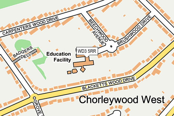
WD3 5RR is located in the Chorleywood South & Maple Cross electoral ward, within the local authority district of Three Rivers and the English Parliamentary constituency of South West Hertfordshire. The Sub Integrated Care Board (ICB) Location is NHS Hertfordshire and West Essex ICB - 06N and the police force is Hertfordshire. This postcode has been in use since January 1980.


GetTheData
Source: OS OpenMap – Local (Ordnance Survey)
Source: OS VectorMap District (Ordnance Survey)
Licence: Open Government Licence (requires attribution)
| Easting | 501958 |
| Northing | 196173 |
| Latitude | 51.655109 |
| Longitude | -0.527530 |
GetTheData
Source: Open Postcode Geo
Licence: Open Government Licence
| Country | England |
| Postcode District | WD3 |
| ➜ WD3 open data dashboard ➜ See where WD3 is on a map ➜ Where is Chorleywood? | |
GetTheData
Source: Land Registry Price Paid Data
Licence: Open Government Licence
Elevation or altitude of WD3 5RR as distance above sea level:
| Metres | Feet | |
|---|---|---|
| Elevation | 100m | 328ft |
Elevation is measured from the approximate centre of the postcode, to the nearest point on an OS contour line from OS Terrain 50, which has contour spacing of ten vertical metres.
➜ How high above sea level am I? Find the elevation of your current position using your device's GPS.
GetTheData
Source: Open Postcode Elevation
Licence: Open Government Licence
| Ward | Chorleywood South & Maple Cross |
| Constituency | South West Hertfordshire |
GetTheData
Source: ONS Postcode Database
Licence: Open Government Licence
| June 2022 | Vehicle crime | On or near Haddon Road | 458m |
| May 2022 | Violence and sexual offences | On or near Shire Lane | 338m |
| May 2022 | Other theft | On or near South Road | 468m |
| ➜ Get more crime data in our Crime section | |||
GetTheData
Source: data.police.uk
Licence: Open Government Licence
| Haddon Road (Shire Lane) | Chorleywood | 349m |
| Haddon Road (Shire Lane) | Chorleywood | 365m |
| Homefield Road (Green Street) | Chorleywood | 509m |
| Homefield Road (Green Street) | Chorleywood | 523m |
| Orchard Drive (Green Street) | Chorleywood | 529m |
| Chorleywood Underground Station | Chorleywood | 633m |
| Chorleywood Station | 0.6km |
| Chalfont & Latimer Station | 2.7km |
| Rickmansworth Station | 4.1km |
GetTheData
Source: NaPTAN
Licence: Open Government Licence


➜ Get more ratings from the Food Standards Agency
GetTheData
Source: Food Standards Agency
Licence: FSA terms & conditions
| Last Collection | |||
|---|---|---|---|
| Location | Mon-Fri | Sat | Distance |
| Blacketts Wood Drive | 17:00 | 12:00 | 71m |
| Haddon Road | 16:00 | 11:30 | 368m |
| Rendlesham Way | 16:00 | 11:30 | 900m |
GetTheData
Source: Dracos
Licence: Creative Commons Attribution-ShareAlike
| Facility | Distance |
|---|---|
| The Russell School Brushwood Drive, Chorleywood, Rickmansworth Grass Pitches, Swimming Pool | 0m |
| Chorleywood Golf Club Common Road, Chorleywood, Rickmansworth Golf | 717m |
| The Swillett Heronsgate Road, Chorleywood Grass Pitches | 1.1km |
GetTheData
Source: Active Places
Licence: Open Government Licence
| School | Phase of Education | Distance |
|---|---|---|
| The Russell School Brushwood Drive, Chorleywood, Rickmansworth, WD3 5RR | Primary | 0m |
| Chorleywood Primary School Stag Lane, Chorleywood, Rickmansworth, WD3 5HR | Primary | 991m |
| St Clement Danes School Chenies Road, Chorleywood, Rickmansworth, WD3 6EW | Secondary | 1.3km |
GetTheData
Source: Edubase
Licence: Open Government Licence
The below table lists the International Territorial Level (ITL) codes (formerly Nomenclature of Territorial Units for Statistics (NUTS) codes) and Local Administrative Units (LAU) codes for WD3 5RR:
| ITL 1 Code | Name |
|---|---|
| TLH | East |
| ITL 2 Code | Name |
| TLH2 | Bedfordshire and Hertfordshire |
| ITL 3 Code | Name |
| TLH23 | Hertfordshire CC |
| LAU 1 Code | Name |
| E07000102 | Three Rivers |
GetTheData
Source: ONS Postcode Directory
Licence: Open Government Licence
The below table lists the Census Output Area (OA), Lower Layer Super Output Area (LSOA), and Middle Layer Super Output Area (MSOA) for WD3 5RR:
| Code | Name | |
|---|---|---|
| OA | E00120950 | |
| LSOA | E01023818 | Three Rivers 005D |
| MSOA | E02004960 | Three Rivers 005 |
GetTheData
Source: ONS Postcode Directory
Licence: Open Government Licence
| WD3 5QH | Blacketts Wood Drive | 90m |
| WD3 5RL | Beechwood Avenue | 100m |
| WD3 5PY | Blacketts Wood Drive | 132m |
| WD3 5RS | Brushwood Drive | 143m |
| WD3 5RT | Brushwood Drive | 148m |
| WD3 5FE | Badgers Dell | 181m |
| WD3 5RN | Carpenters Wood Drive | 189m |
| WD3 5RH | Carpenters Wood Drive | 191m |
| WD3 5RJ | Carpenters Wood Drive | 194m |
| WD3 5PU | Grovewood Close | 199m |
GetTheData
Source: Open Postcode Geo; Land Registry Price Paid Data
Licence: Open Government Licence