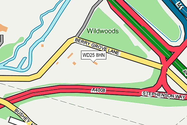
WD25 8HN lies on Berry Grove Cottages in Watford. WD25 8HN is located in the Bushey North electoral ward, within the local authority district of Hertsmere and the English Parliamentary constituency of Hertsmere. The Sub Integrated Care Board (ICB) Location is NHS Hertfordshire and West Essex ICB - 06N and the police force is Hertfordshire. This postcode has been in use since October 2000.


GetTheData
Source: OS OpenMap – Local (Ordnance Survey)
Source: OS VectorMap District (Ordnance Survey)
Licence: Open Government Licence (requires attribution)
| Easting | 512503 |
| Northing | 198168 |
| Latitude | 51.671035 |
| Longitude | -0.374493 |
GetTheData
Source: Open Postcode Geo
Licence: Open Government Licence
| Street | Berry Grove Cottages |
| Town/City | Watford |
| Country | England |
| Postcode District | WD25 |
| ➜ WD25 open data dashboard ➜ See where WD25 is on a map | |
GetTheData
Source: Land Registry Price Paid Data
Licence: Open Government Licence
Elevation or altitude of WD25 8HN as distance above sea level:
| Metres | Feet | |
|---|---|---|
| Elevation | 60m | 197ft |
Elevation is measured from the approximate centre of the postcode, to the nearest point on an OS contour line from OS Terrain 50, which has contour spacing of ten vertical metres.
➜ How high above sea level am I? Find the elevation of your current position using your device's GPS.
GetTheData
Source: Open Postcode Elevation
Licence: Open Government Licence
| Ward | Bushey North |
| Constituency | Hertsmere |
GetTheData
Source: ONS Postcode Database
Licence: Open Government Licence
| June 2022 | Violence and sexual offences | On or near Highwood Avenue | 438m |
| April 2022 | Criminal damage and arson | On or near A41 | 452m |
| March 2022 | Anti-social behaviour | On or near Highwood Avenue | 438m |
| ➜ Get more crime data in our Crime section | |||
GetTheData
Source: data.police.uk
Licence: Open Government Licence
| Radlett Road (Bushey Mill Lane) | North Watford | 537m |
| Woodmere Avenue | North Watford | 560m |
| Scottswood Road (Mead Way) | North Bushey | 564m |
| Woodmere Avenue | North Watford | 589m |
| Douglas Avenue (Woodmere Avenue) | North Watford | 590m |
| Watford North Station | 1.2km |
| Watford Junction Station | 1.7km |
| Garston (Herts) Station | 1.8km |
GetTheData
Source: NaPTAN
Licence: Open Government Licence
| Percentage of properties with Next Generation Access | 100.0% |
| Percentage of properties with Superfast Broadband | 100.0% |
| Percentage of properties with Ultrafast Broadband | 0.0% |
| Percentage of properties with Full Fibre Broadband | 0.0% |
Superfast Broadband is between 30Mbps and 300Mbps
Ultrafast Broadband is > 300Mbps
| Percentage of properties unable to receive 2Mbps | 0.0% |
| Percentage of properties unable to receive 5Mbps | 0.0% |
| Percentage of properties unable to receive 10Mbps | 0.0% |
| Percentage of properties unable to receive 30Mbps | 0.0% |
GetTheData
Source: Ofcom
Licence: Ofcom Terms of Use (requires attribution)
GetTheData
Source: ONS Postcode Database
Licence: Open Government Licence


➜ Get more ratings from the Food Standards Agency
GetTheData
Source: Food Standards Agency
Licence: FSA terms & conditions
| Last Collection | |||
|---|---|---|---|
| Location | Mon-Fri | Sat | Distance |
| North Watford P.o | 18:30 | 12:00 | 857m |
| Imperial Way | 19:00 | 12:00 | 1,209m |
| Parkgate Road | 18:30 | 12:00 | 1,409m |
GetTheData
Source: Dracos
Licence: Creative Commons Attribution-ShareAlike
| Facility | Distance |
|---|---|
| Topgolf Watford Bushey Mill Lane, Watford Golf | 335m |
| Graftism Gym Otterspool Way, Watford Health and Fitness Gym | 658m |
| Knutsford Playing Fields Radlett Road, Watford Grass Pitches | 856m |
GetTheData
Source: Active Places
Licence: Open Government Licence
| School | Phase of Education | Distance |
|---|---|---|
| Highwood Primary School Mead Way, Bushey, WD23 2AW | Primary | 604m |
| Knutsford Primary Academy Balmoral Road, Watford, WD24 7ER | Primary | 882m |
| The Purcell School Aldenham Road, Bushey, WD23 2TS | Not applicable | 1.3km |
GetTheData
Source: Edubase
Licence: Open Government Licence
The below table lists the International Territorial Level (ITL) codes (formerly Nomenclature of Territorial Units for Statistics (NUTS) codes) and Local Administrative Units (LAU) codes for WD25 8HN:
| ITL 1 Code | Name |
|---|---|
| TLH | East |
| ITL 2 Code | Name |
| TLH2 | Bedfordshire and Hertfordshire |
| ITL 3 Code | Name |
| TLH23 | Hertfordshire CC |
| LAU 1 Code | Name |
| E07000098 | Hertsmere |
GetTheData
Source: ONS Postcode Directory
Licence: Open Government Licence
The below table lists the Census Output Area (OA), Lower Layer Super Output Area (LSOA), and Middle Layer Super Output Area (MSOA) for WD25 8HN:
| Code | Name | |
|---|---|---|
| OA | E00119626 | |
| LSOA | E01023552 | Hertsmere 008A |
| MSOA | E02004903 | Hertsmere 008 |
GetTheData
Source: ONS Postcode Directory
Licence: Open Government Licence
| WD23 2AD | Bushey Mill Lane | 297m |
| WD25 8AA | Otterspool | 324m |
| WD23 2AU | Bushey Mill Lane | 338m |
| WD23 2AH | Bushey Mill Lane | 386m |
| WD23 2AL | Highwood Avenue | 401m |
| WD23 2AR | Marion Close | 472m |
| WD23 2AJ | Bushey Mill Lane | 479m |
| WD23 2AQ | Mill Way | 502m |
| WD23 2AE | Mill Way | 506m |
| WD24 7LN | Woodmere Avenue | 550m |
GetTheData
Source: Open Postcode Geo; Land Registry Price Paid Data
Licence: Open Government Licence