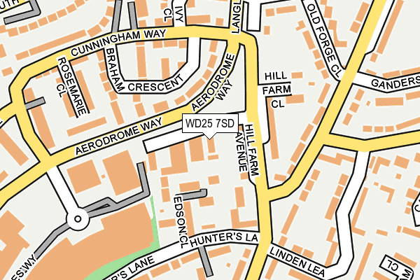
WD25 7SD is located in the Leavesden electoral ward, within the local authority district of Three Rivers and the English Parliamentary constituency of Watford. The Sub Integrated Care Board (ICB) Location is NHS Hertfordshire and West Essex ICB - 06N and the police force is Hertfordshire. This postcode has been in use since June 2002.


GetTheData
Source: OS OpenMap – Local (Ordnance Survey)
Source: OS VectorMap District (Ordnance Survey)
Licence: Open Government Licence (requires attribution)
| Easting | 510011 |
| Northing | 200745 |
| Latitude | 51.694690 |
| Longitude | -0.409703 |
GetTheData
Source: Open Postcode Geo
Licence: Open Government Licence
| Country | England |
| Postcode District | WD25 |
| ➜ WD25 open data dashboard ➜ See where WD25 is on a map ➜ Where is Watford? | |
GetTheData
Source: Land Registry Price Paid Data
Licence: Open Government Licence
Elevation or altitude of WD25 7SD as distance above sea level:
| Metres | Feet | |
|---|---|---|
| Elevation | 90m | 295ft |
Elevation is measured from the approximate centre of the postcode, to the nearest point on an OS contour line from OS Terrain 50, which has contour spacing of ten vertical metres.
➜ How high above sea level am I? Find the elevation of your current position using your device's GPS.
GetTheData
Source: Open Postcode Elevation
Licence: Open Government Licence
| Ward | Leavesden |
| Constituency | Watford |
GetTheData
Source: ONS Postcode Database
Licence: Open Government Licence
| January 2024 | Other crime | On or near Edinburgh Drive | 467m |
| November 2023 | Violence and sexual offences | On or near Edinburgh Drive | 467m |
| October 2023 | Anti-social behaviour | On or near Linden Lea | 229m |
| ➜ Get more crime data in our Crime section | |||
GetTheData
Source: data.police.uk
Licence: Open Government Licence
| Hill Farm Avenue | Abbots Langley | 83m |
| Hill Farm Avenue | Abbots Langley | 100m |
| Hercules Way North (Airfield Way) | Leavesden | 157m |
| Linden Lea (High Road) | Leavesden | 188m |
| Ganders Ash (High Road) | Woodside | 207m |
| Garston (Herts) Station | 2.1km |
| Kings Langley Station | 2.4km |
| Watford North Station | 2.5km |
GetTheData
Source: NaPTAN
Licence: Open Government Licence
GetTheData
Source: ONS Postcode Database
Licence: Open Government Licence


➜ Get more ratings from the Food Standards Agency
GetTheData
Source: Food Standards Agency
Licence: FSA terms & conditions
| Last Collection | |||
|---|---|---|---|
| Location | Mon-Fri | Sat | Distance |
| Briar Road | 18:30 | 12:00 | 262m |
| Abbey Drive | 17:00 | 12:00 | 348m |
| Katherine Place | 17:00 | 12:00 | 811m |
GetTheData
Source: Dracos
Licence: Creative Commons Attribution-ShareAlike
| Facility | Distance |
|---|---|
| Kingsway Junior School Briar Road, Watford Grass Pitches, Swimming Pool | 693m |
| Watford Town Cricket Club Horseshoe Lane, Horseshoe Lane, Watford Grass Pitches | 988m |
| Tannerswood School Hazelwood Lane, Abbots Langley Grass Pitches | 1.1km |
GetTheData
Source: Active Places
Licence: Open Government Licence
| School | Phase of Education | Distance |
|---|---|---|
| Leavesden JMI School High Road, Leavesden, Watford, WD25 7QZ | Primary | 347m |
| Kingsway Infants' School North Approach, Watford, WD25 0ES | Primary | 607m |
| Kingsway Junior School Briar Road, Watford, WD25 0JH | Primary | 693m |
GetTheData
Source: Edubase
Licence: Open Government Licence
The below table lists the International Territorial Level (ITL) codes (formerly Nomenclature of Territorial Units for Statistics (NUTS) codes) and Local Administrative Units (LAU) codes for WD25 7SD:
| ITL 1 Code | Name |
|---|---|
| TLH | East |
| ITL 2 Code | Name |
| TLH2 | Bedfordshire and Hertfordshire |
| ITL 3 Code | Name |
| TLH23 | Hertfordshire CC |
| LAU 1 Code | Name |
| E07000102 | Three Rivers |
GetTheData
Source: ONS Postcode Directory
Licence: Open Government Licence
The below table lists the Census Output Area (OA), Lower Layer Super Output Area (LSOA), and Middle Layer Super Output Area (MSOA) for WD25 7SD:
| Code | Name | |
|---|---|---|
| OA | E00169775 | |
| LSOA | E01023833 | Three Rivers 002D |
| MSOA | E02004957 | Three Rivers 002 |
GetTheData
Source: ONS Postcode Directory
Licence: Open Government Licence
| WD25 7BJ | Hill Farm Avenue | 65m |
| WD25 7BX | Edson Close | 84m |
| WD25 7NN | Braham Crescent | 110m |
| WD25 7HG | Hunters Lane | 112m |
| WD25 7BD | Hunters Lane | 118m |
| WD25 7BQ | Hill Farm Avenue | 118m |
| WD25 7BB | Hammer Parade | 154m |
| WD25 7BG | Hill Farm Close | 159m |
| WD25 7DU | High Road | 164m |
| WD25 7NP | Rosemarie Close | 168m |
GetTheData
Source: Open Postcode Geo; Land Registry Price Paid Data
Licence: Open Government Licence