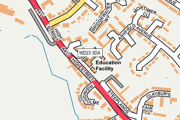
WD23 3DA is located in the Bushey Park electoral ward, within the local authority district of Hertsmere and the English Parliamentary constituency of Hertsmere. The Sub Integrated Care Board (ICB) Location is NHS Hertfordshire and West Essex ICB - 06N and the police force is Hertfordshire. This postcode has been in use since October 2000.


GetTheData
Source: OS OpenMap – Local (Ordnance Survey)
Source: OS VectorMap District (Ordnance Survey)
Licence: Open Government Licence (requires attribution)
| Easting | 513687 |
| Northing | 194955 |
| Latitude | 51.641915 |
| Longitude | -0.358446 |
GetTheData
Source: Open Postcode Geo
Licence: Open Government Licence
| Country | England |
| Postcode District | WD23 |
| ➜ WD23 open data dashboard ➜ See where WD23 is on a map ➜ Where is Bushey? | |
GetTheData
Source: Land Registry Price Paid Data
Licence: Open Government Licence
Elevation or altitude of WD23 3DA as distance above sea level:
| Metres | Feet | |
|---|---|---|
| Elevation | 100m | 328ft |
Elevation is measured from the approximate centre of the postcode, to the nearest point on an OS contour line from OS Terrain 50, which has contour spacing of ten vertical metres.
➜ How high above sea level am I? Find the elevation of your current position using your device's GPS.
GetTheData
Source: Open Postcode Elevation
Licence: Open Government Licence
| Ward | Bushey Park |
| Constituency | Hertsmere |
GetTheData
Source: ONS Postcode Database
Licence: Open Government Licence
| June 2022 | Violence and sexual offences | On or near Meadowcroft | 68m |
| June 2022 | Robbery | On or near Meadowcroft | 68m |
| June 2022 | Criminal damage and arson | On or near Meadowcroft | 68m |
| ➜ Get more crime data in our Crime section | |||
GetTheData
Source: data.police.uk
Licence: Open Government Licence
| Steeplands (High Street) | Bushey | 102m |
| Melbourne Road (High Street) | Bushey | 117m |
| Steeplands (High Street) | Bushey | 143m |
| Melbourne Road (High Street) | Bushey | 220m |
| The Royal Oak Ph (Sparrows Herne) | Bushey | 350m |
| Bushey Station | 1.9km |
| Carpenders Park Station | 2.4km |
| Watford High Street Station | 2.6km |
GetTheData
Source: NaPTAN
Licence: Open Government Licence
GetTheData
Source: ONS Postcode Database
Licence: Open Government Licence


➜ Get more ratings from the Food Standards Agency
GetTheData
Source: Food Standards Agency
Licence: FSA terms & conditions
| Last Collection | |||
|---|---|---|---|
| Location | Mon-Fri | Sat | Distance |
| Bushey P.o | 18:30 | 12:00 | 569m |
| Bushey Heath P.o | 19:00 | 12:00 | 1,310m |
| The Avenue | 18:30 | 12:00 | 1,341m |
GetTheData
Source: Dracos
Licence: Creative Commons Attribution-ShareAlike
| Facility | Distance |
|---|---|
| Bushey Country Club (Closed) High Street, Bushey Health and Fitness Gym, Golf, Studio | 315m |
| St Margarets Sports Centre St Margarets School Complex Loop Road, Bushey Sports Hall, Swimming Pool, Health and Fitness Gym, Studio | 356m |
| King George V Playing Field (Bushey) King George Avenue, Bushey Outdoor Tennis Courts | 383m |
GetTheData
Source: Active Places
Licence: Open Government Licence
| School | Phase of Education | Distance |
|---|---|---|
| St Hilda's School High Street, Bushey, WD23 3DA | Not applicable | 0m |
| Ashfield Junior School School Lane, Bushey, WD23 1SR | Primary | 295m |
| St Margaret's School Merry Hill Road, Bushey, WD23 1DT | Not applicable | 462m |
GetTheData
Source: Edubase
Licence: Open Government Licence
The below table lists the International Territorial Level (ITL) codes (formerly Nomenclature of Territorial Units for Statistics (NUTS) codes) and Local Administrative Units (LAU) codes for WD23 3DA:
| ITL 1 Code | Name |
|---|---|
| TLH | East |
| ITL 2 Code | Name |
| TLH2 | Bedfordshire and Hertfordshire |
| ITL 3 Code | Name |
| TLH23 | Hertfordshire CC |
| LAU 1 Code | Name |
| E07000098 | Hertsmere |
GetTheData
Source: ONS Postcode Directory
Licence: Open Government Licence
The below table lists the Census Output Area (OA), Lower Layer Super Output Area (LSOA), and Middle Layer Super Output Area (MSOA) for WD23 3DA:
| Code | Name | |
|---|---|---|
| OA | E00119648 | |
| LSOA | E01023558 | Hertsmere 012A |
| MSOA | E02004907 | Hertsmere 012 |
GetTheData
Source: ONS Postcode Directory
Licence: Open Government Licence
| WD23 3BY | Meadowcroft | 42m |
| WD23 1BL | High Street | 62m |
| WD23 4TE | Ashfield Avenue | 70m |
| WD23 3BX | Meadowcroft | 85m |
| WD23 4TH | Ashfield Avenue | 101m |
| WD23 4UF | Fidler Place | 105m |
| WD23 4TB | Ashfield Avenue | 121m |
| WD23 4TJ | Ashfield Avenue | 126m |
| WD23 1BT | Steeplands | 127m |
| WD23 4UE | Wheelwright Close | 131m |
GetTheData
Source: Open Postcode Geo; Land Registry Price Paid Data
Licence: Open Government Licence