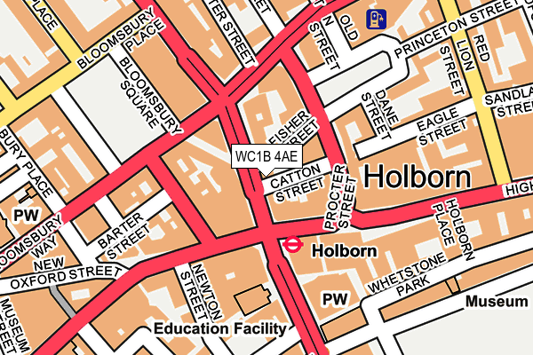
WC1B 4AE is located in the Holborn & Covent Garden electoral ward, within the London borough of Camden and the English Parliamentary constituency of Holborn and St Pancras. The Sub Integrated Care Board (ICB) Location is NHS North Central London ICB - 93C and the police force is Metropolitan Police. This postcode has been in use since December 1994.


GetTheData
Source: OS OpenMap – Local (Ordnance Survey)
Source: OS VectorMap District (Ordnance Survey)
Licence: Open Government Licence (requires attribution)
| Easting | 530509 |
| Northing | 181597 |
| Latitude | 51.518227 |
| Longitude | -0.120408 |
GetTheData
Source: Open Postcode Geo
Licence: Open Government Licence
| Country | England |
| Postcode District | WC1B |
| ➜ WC1B open data dashboard ➜ See where WC1B is on a map ➜ Where is London? | |
GetTheData
Source: Land Registry Price Paid Data
Licence: Open Government Licence
Elevation or altitude of WC1B 4AE as distance above sea level:
| Metres | Feet | |
|---|---|---|
| Elevation | 20m | 66ft |
Elevation is measured from the approximate centre of the postcode, to the nearest point on an OS contour line from OS Terrain 50, which has contour spacing of ten vertical metres.
➜ How high above sea level am I? Find the elevation of your current position using your device's GPS.
GetTheData
Source: Open Postcode Elevation
Licence: Open Government Licence
| Ward | Holborn & Covent Garden |
| Constituency | Holborn And St Pancras |
GetTheData
Source: ONS Postcode Database
Licence: Open Government Licence
| January 2024 | Anti-social behaviour | On or near Nightclub | 210m |
| January 2024 | Anti-social behaviour | On or near Nightclub | 210m |
| January 2024 | Anti-social behaviour | On or near Nightclub | 210m |
| ➜ Get more crime data in our Crime section | |||
GetTheData
Source: data.police.uk
Licence: Open Government Licence
| Procter Street | Holborn | 89m |
| Bloomsbury Square | Holborn | 100m |
| Red Lion Square (Drake Street) | Holborn | 106m |
| High Holborn | Holborn | 116m |
| Bloomsbury Square | Holborn | 121m |
| Holborn Underground Station | Holborn | 72m |
| Russell Square Underground Station | Russell Square | 602m |
| Chancery Lane Underground Station | Chancery Lane | 614m |
| Covent Garden Underground Station | Covent Garden | 635m |
| Tottenham Court Road Underground Station | Tottenham Court Road | 721m |
| Farringdon (London) Station | 1.1km |
| London Charing Cross Station | 1.2km |
| City Thameslink Station | 1.3km |
GetTheData
Source: NaPTAN
Licence: Open Government Licence
GetTheData
Source: ONS Postcode Database
Licence: Open Government Licence


➜ Get more ratings from the Food Standards Agency
GetTheData
Source: Food Standards Agency
Licence: FSA terms & conditions
| Last Collection | |||
|---|---|---|---|
| Location | Mon-Fri | Sat | Distance |
| Southampton Row (O/S 25) | 18:30 | 12:00 | 39m |
| High Holborn | 18:30 | 97m | |
| High Holborn (Southampton Pl) | 18:30 | 12:00 | 98m |
GetTheData
Source: Dracos
Licence: Creative Commons Attribution-ShareAlike
| Facility | Distance |
|---|---|
| Gymbox (Holborn) High Holborn, London Health and Fitness Gym, Studio | 115m |
| Rena Health & Leisure Southampton Row, London Health and Fitness Gym, Swimming Pool | 130m |
| Fitness First (High Holborn) (Closed) High Holborn, London Health and Fitness Gym, Studio | 145m |
GetTheData
Source: Active Places
Licence: Open Government Licence
| School | Phase of Education | Distance |
|---|---|---|
| Guildhouse School 43-45 Bloomsbury Square & 2 Southampton Place, London, WC1A 2RA | Not applicable | 146m |
| St Josephs Catholic Primary School Macklin Street, Covent Garden, London, WC2B 5NA | Primary | 248m |
| University of the Arts London 272 High Holborn, London, WC1V 7EY | Not applicable | 281m |
GetTheData
Source: Edubase
Licence: Open Government Licence
The below table lists the International Territorial Level (ITL) codes (formerly Nomenclature of Territorial Units for Statistics (NUTS) codes) and Local Administrative Units (LAU) codes for WC1B 4AE:
| ITL 1 Code | Name |
|---|---|
| TLI | London |
| ITL 2 Code | Name |
| TLI3 | Inner London - West |
| ITL 3 Code | Name |
| TLI31 | Camden and City of London |
| LAU 1 Code | Name |
| E09000007 | Camden |
GetTheData
Source: ONS Postcode Directory
Licence: Open Government Licence
The below table lists the Census Output Area (OA), Lower Layer Super Output Area (LSOA), and Middle Layer Super Output Area (MSOA) for WC1B 4AE:
| Code | Name | |
|---|---|---|
| OA | E00004554 | |
| LSOA | E01000914 | Camden 028B |
| MSOA | E02000193 | Camden 028 |
GetTheData
Source: ONS Postcode Directory
Licence: Open Government Licence
| WC1B 5HA | Southampton Row | 48m |
| WC1V 6JJ | High Holborn | 50m |
| WC1A 2QH | Sicilian Avenue | 65m |
| WC1R 4QG | Red Lion Square | 108m |
| WC1V 7DX | Little Turnstile | 129m |
| WC2B 5EN | Newton Street | 138m |
| WC1A 2ED | Barter Street | 145m |
| WC2B 6AH | Kingsway | 148m |
| WC1A 2AH | Barter Street | 159m |
| WC1B 4DA | Southampton Row | 161m |
GetTheData
Source: Open Postcode Geo; Land Registry Price Paid Data
Licence: Open Government Licence