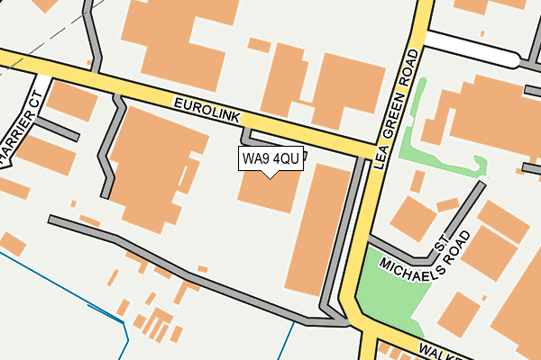
WA9 4QU lies on Lea Green Road in St Helens. WA9 4QU is located in the Bold & Lea Green electoral ward, within the metropolitan district of St. Helens and the English Parliamentary constituency of St Helens South and Whiston. The Sub Integrated Care Board (ICB) Location is NHS Cheshire and Merseyside ICB - 01X and the police force is Merseyside. This postcode has been in use since January 1995.


GetTheData
Source: OS OpenMap – Local (Ordnance Survey)
Source: OS VectorMap District (Ordnance Survey)
Licence: Open Government Licence (requires attribution)
| Easting | 350906 |
| Northing | 391423 |
| Latitude | 53.417313 |
| Longitude | -2.740133 |
GetTheData
Source: Open Postcode Geo
Licence: Open Government Licence
| Street | Lea Green Road |
| Town/City | St Helens |
| Country | England |
| Postcode District | WA9 |
| ➜ WA9 open data dashboard ➜ See where WA9 is on a map ➜ Where is St Helens? | |
GetTheData
Source: Land Registry Price Paid Data
Licence: Open Government Licence
Elevation or altitude of WA9 4QU as distance above sea level:
| Metres | Feet | |
|---|---|---|
| Elevation | 50m | 164ft |
Elevation is measured from the approximate centre of the postcode, to the nearest point on an OS contour line from OS Terrain 50, which has contour spacing of ten vertical metres.
➜ How high above sea level am I? Find the elevation of your current position using your device's GPS.
GetTheData
Source: Open Postcode Elevation
Licence: Open Government Licence
| Ward | Bold & Lea Green |
| Constituency | St Helens South And Whiston |
GetTheData
Source: ONS Postcode Database
Licence: Open Government Licence
| June 2022 | Vehicle crime | On or near Eurolink | 138m |
| June 2022 | Robbery | On or near Eurolink | 138m |
| June 2022 | Drugs | On or near Eurolink | 138m |
| ➜ Get more crime data in our Crime section | |||
GetTheData
Source: data.police.uk
Licence: Open Government Licence
| St Michaels Road (Lea Green Road) | Micklehead Green | 104m |
| St Michaels Road (Lea Green Road) | Micklehead Green | 131m |
| St Michaels Road (Lea Green Road) | Sutton Manor | 351m |
| St Michaels Road (Lea Green Road) | Sutton Manor | 359m |
| Forest Road | Micklehead Green | 372m |
| Lea Green Station | 1.5km |
| Rainhill Station | 1.7km |
| Thatto Heath Station | 2.5km |
GetTheData
Source: NaPTAN
Licence: Open Government Licence
GetTheData
Source: ONS Postcode Database
Licence: Open Government Licence


➜ Get more ratings from the Food Standards Agency
GetTheData
Source: Food Standards Agency
Licence: FSA terms & conditions
| Last Collection | |||
|---|---|---|---|
| Location | Mon-Fri | Sat | Distance |
| Mill Lane | 17:30 | 11:00 | 1,635m |
| Elephant Lane | 17:30 | 11:00 | 1,791m |
| Robins Lane Post Office | 17:00 | 12:00 | 2,195m |
GetTheData
Source: Dracos
Licence: Creative Commons Attribution-ShareAlike
| Facility | Distance |
|---|---|
| Shining Lights Centre Forest Road, Sutton Manor Sports Hall | 646m |
| Sutton Manor Primary School Forest Road, Sutton Manor, St. Helens Sports Hall | 720m |
| King George V Playing Fields (Sutton Manor) Jubits Lane, Sutton Manor, St. Helens Grass Pitches | 889m |
GetTheData
Source: Active Places
Licence: Open Government Licence
| School | Phase of Education | Distance |
|---|---|---|
| Sutton Manor Community Primary School Forest Road, Sutton Manor, st Helens, WA9 4AT | Primary | 717m |
| Ash Meadow School Jubits Lane, St Helens, WA9 4RT | Not applicable | 1.1km |
| Rainhill Community Nursery Deepdale Drive, Rainhill, Prescot, L35 4NW | Nursery | 1.1km |
GetTheData
Source: Edubase
Licence: Open Government Licence
The below table lists the International Territorial Level (ITL) codes (formerly Nomenclature of Territorial Units for Statistics (NUTS) codes) and Local Administrative Units (LAU) codes for WA9 4QU:
| ITL 1 Code | Name |
|---|---|
| TLD | North West (England) |
| ITL 2 Code | Name |
| TLD7 | Merseyside |
| ITL 3 Code | Name |
| TLD71 | East Merseyside |
| LAU 1 Code | Name |
| E08000013 | St. Helens |
GetTheData
Source: ONS Postcode Directory
Licence: Open Government Licence
The below table lists the Census Output Area (OA), Lower Layer Super Output Area (LSOA), and Middle Layer Super Output Area (MSOA) for WA9 4QU:
| Code | Name | |
|---|---|---|
| OA | E00035021 | |
| LSOA | E01006910 | St. Helens 022E |
| MSOA | E02001427 | St. Helens 022 |
GetTheData
Source: ONS Postcode Directory
Licence: Open Government Licence
| WA9 4AG | Micklehead Green | 171m |
| WA9 4YR | Eurolink Business Park | 244m |
| WA9 4AQ | Walkers Lane | 300m |
| WA9 4AE | Walkers Lane | 381m |
| WA9 4AD | Walkers Lane | 453m |
| WA9 4AN | Scott Avenue | 480m |
| WA9 4AH | Forest Road | 485m |
| WA9 4BU | Mcgough Close | 492m |
| WA9 4BN | Kipling Grove | 520m |
| WA9 4BX | Hardie Close | 565m |
GetTheData
Source: Open Postcode Geo; Land Registry Price Paid Data
Licence: Open Government Licence