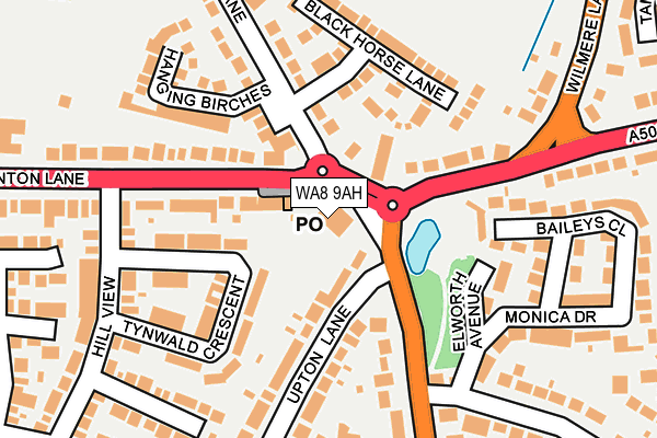
WA8 9AH is located in the Birchfield electoral ward, within the unitary authority of Halton and the English Parliamentary constituency of Halton. The Sub Integrated Care Board (ICB) Location is NHS Cheshire and Merseyside ICB - 01F and the police force is Cheshire. This postcode has been in use since January 1980.


GetTheData
Source: OS OpenMap – Local (Ordnance Survey)
Source: OS VectorMap District (Ordnance Survey)
Licence: Open Government Licence (requires attribution)
| Easting | 350974 |
| Northing | 388330 |
| Latitude | 53.389520 |
| Longitude | -2.738628 |
GetTheData
Source: Open Postcode Geo
Licence: Open Government Licence
| Country | England |
| Postcode District | WA8 |
| ➜ WA8 open data dashboard ➜ See where WA8 is on a map ➜ Where is Widnes? | |
GetTheData
Source: Land Registry Price Paid Data
Licence: Open Government Licence
Elevation or altitude of WA8 9AH as distance above sea level:
| Metres | Feet | |
|---|---|---|
| Elevation | 50m | 164ft |
Elevation is measured from the approximate centre of the postcode, to the nearest point on an OS contour line from OS Terrain 50, which has contour spacing of ten vertical metres.
➜ How high above sea level am I? Find the elevation of your current position using your device's GPS.
GetTheData
Source: Open Postcode Elevation
Licence: Open Government Licence
| Ward | Birchfield |
| Constituency | Halton |
GetTheData
Source: ONS Postcode Database
Licence: Open Government Licence
| June 2023 | Violence and sexual offences | On or near Stratton Park | 379m |
| May 2023 | Violence and sexual offences | On or near Stratton Park | 379m |
| April 2023 | Violence and sexual offences | On or near Stratton Park | 379m |
| ➜ Get more crime data in our Crime section | |||
GetTheData
Source: data.police.uk
Licence: Open Government Licence
| The Globe (Birchfield Road) | Upton Rocks | 30m |
| The Globe (Birchfield Road) | Lunt's Heath | 122m |
| The Globe (Lunnts Heath Road) | Upton Rocks | 134m |
| The Globe (Lunts Heath Road) | Lunt's Heath | 135m |
| Wilmere Lane (Lunts Heath Road) | Lunt's Heath | 264m |
| Widnes Station | 1.3km |
| Hough Green Station | 3.1km |
| Rainhill Station | 3.6km |
GetTheData
Source: NaPTAN
Licence: Open Government Licence
GetTheData
Source: ONS Postcode Database
Licence: Open Government Licence


➜ Get more ratings from the Food Standards Agency
GetTheData
Source: Food Standards Agency
Licence: FSA terms & conditions
| Last Collection | |||
|---|---|---|---|
| Location | Mon-Fri | Sat | Distance |
| Blackhorse Post Office | 18:00 | 12:00 | 949m |
| Beaconsfield | 17:15 | 11:00 | 1,124m |
| Farnworth S.o. | 17:15 | 12:00 | 1,253m |
GetTheData
Source: Dracos
Licence: Creative Commons Attribution-ShareAlike
| Facility | Distance |
|---|---|
| Jaguar Land Rover Sports And Social Club Cronton Lane, Widnes Sports Hall, Grass Pitches | 363m |
| Birchfield Sports And Social Club Birchfield Road, Widnes Grass Pitches | 428m |
| Wilmere Lane Playing Fields Wilmere Lane, Widnes Grass Pitches | 463m |
GetTheData
Source: Active Places
Licence: Open Government Licence
| School | Phase of Education | Distance |
|---|---|---|
| Lunts Heath Primary School Wedgewood Drive, Widnes, WA8 9RJ | Primary | 722m |
| Farnworth Church of England Controlled Primary School Pit Lane, Widnes, WA8 9HS | Primary | 752m |
| Birchfield Nursery School Victoria Avenue, Victoria Avenue, widnes, WA8 7TH | Nursery | 1.3km |
GetTheData
Source: Edubase
Licence: Open Government Licence
The below table lists the International Territorial Level (ITL) codes (formerly Nomenclature of Territorial Units for Statistics (NUTS) codes) and Local Administrative Units (LAU) codes for WA8 9AH:
| ITL 1 Code | Name |
|---|---|
| TLD | North West (England) |
| ITL 2 Code | Name |
| TLD7 | Merseyside |
| ITL 3 Code | Name |
| TLD71 | East Merseyside |
| LAU 1 Code | Name |
| E06000006 | Halton |
GetTheData
Source: ONS Postcode Directory
Licence: Open Government Licence
The below table lists the Census Output Area (OA), Lower Layer Super Output Area (LSOA), and Middle Layer Super Output Area (MSOA) for WA8 9AH:
| Code | Name | |
|---|---|---|
| OA | E00062526 | |
| LSOA | E01012393 | Halton 001B |
| MSOA | E02002574 | Halton 001 |
GetTheData
Source: ONS Postcode Directory
Licence: Open Government Licence
| WA8 5AJ | Cronton Lane | 99m |
| WA8 5AZ | Lunts Heath Road | 103m |
| WA8 5AY | Norlands Lane | 128m |
| WA8 9AQ | Upton Lane | 133m |
| WA8 9AN | Tynwald Crescent | 137m |
| WA8 5AF | Black Horse Lane | 147m |
| WA8 9JW | Elworth Avenue | 166m |
| WA8 9AR | Cronton Lane | 179m |
| WA8 5BJ | Hanging Birches | 189m |
| WA8 9AL | Hill View | 223m |
GetTheData
Source: Open Postcode Geo; Land Registry Price Paid Data
Licence: Open Government Licence