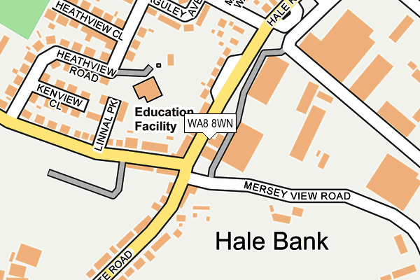
WA8 8WN is located in the Ditton, Hale Village & Halebank electoral ward, within the unitary authority of Halton and the English Parliamentary constituency of Halton. The Sub Integrated Care Board (ICB) Location is NHS Cheshire and Merseyside ICB - 01F and the police force is Cheshire. This postcode has been in use since December 1999.


GetTheData
Source: OS OpenMap – Local (Ordnance Survey)
Source: OS VectorMap District (Ordnance Survey)
Licence: Open Government Licence (requires attribution)
| Easting | 348533 |
| Northing | 383913 |
| Latitude | 53.349588 |
| Longitude | -2.774607 |
GetTheData
Source: Open Postcode Geo
Licence: Open Government Licence
| Country | England |
| Postcode District | WA8 |
| ➜ WA8 open data dashboard ➜ See where WA8 is on a map ➜ Where is Hale Bank? | |
GetTheData
Source: Land Registry Price Paid Data
Licence: Open Government Licence
Elevation or altitude of WA8 8WN as distance above sea level:
| Metres | Feet | |
|---|---|---|
| Elevation | 10m | 33ft |
Elevation is measured from the approximate centre of the postcode, to the nearest point on an OS contour line from OS Terrain 50, which has contour spacing of ten vertical metres.
➜ How high above sea level am I? Find the elevation of your current position using your device's GPS.
GetTheData
Source: Open Postcode Elevation
Licence: Open Government Licence
| Ward | Ditton, Hale Village & Halebank |
| Constituency | Halton |
GetTheData
Source: ONS Postcode Database
Licence: Open Government Licence
| June 2022 | Criminal damage and arson | On or near Cock Lane Ends | 56m |
| June 2022 | Violence and sexual offences | On or near Cock Lane Ends | 56m |
| June 2022 | Public order | On or near Blackburne Avenue | 369m |
| ➜ Get more crime data in our Crime section | |||
GetTheData
Source: data.police.uk
Licence: Open Government Licence
| Merseyview (Hale Road) | Ditton | 87m |
| Merseyview | Ditton | 107m |
| Merseyview (Hale Gate Road) | Ditton | 135m |
| Cock & Trumpet (Hale Bank Road) | Ditton | 164m |
| Baguley Ave. (Hale Road) | Ditton | 202m |
| Hough Green Station | 2.5km |
| Runcorn Station | 2.6km |
| Halewood Station | 4.1km |
GetTheData
Source: NaPTAN
Licence: Open Government Licence
GetTheData
Source: ONS Postcode Database
Licence: Open Government Licence


➜ Get more ratings from the Food Standards Agency
GetTheData
Source: Food Standards Agency
Licence: FSA terms & conditions
| Last Collection | |||
|---|---|---|---|
| Location | Mon-Fri | Sat | Distance |
| Merseyview Road | 16:00 | 11:00 | 57m |
| Hale Post Office | 16:30 | 12:00 | 2,296m |
| Portland Street | 17:00 | 11:00 | 2,340m |
GetTheData
Source: Dracos
Licence: Creative Commons Attribution-ShareAlike
| Facility | Distance |
|---|---|
| Halebank Recreation Ground Blackburne Avenue, Widnes Grass Pitches | 380m |
| Optimum Fitness (Closed) Everite Road Industrial Estate, Westgate, Widnes Health and Fitness Gym, Studio | 1.2km |
| Optimum Fitness St. Michaels Industrial Estate, Widnes Health and Fitness Gym, Studio, Sports Hall | 1.4km |
GetTheData
Source: Active Places
Licence: Open Government Licence
| School | Phase of Education | Distance |
|---|---|---|
| Halebank CofE Primary School Heathview Road, Halebank, Widnes, WA8 8UZ | Primary | 111m |
| St Michaels Catholic Primary School St Michael's Road, Widnes, WA8 8TD | Primary | 1.4km |
| Our Lady of Perpetual Succour Catholic Primary School Clincton View, Widnes, WA8 8JN | Primary | 1.8km |
GetTheData
Source: Edubase
Licence: Open Government Licence
The below table lists the International Territorial Level (ITL) codes (formerly Nomenclature of Territorial Units for Statistics (NUTS) codes) and Local Administrative Units (LAU) codes for WA8 8WN:
| ITL 1 Code | Name |
|---|---|
| TLD | North West (England) |
| ITL 2 Code | Name |
| TLD7 | Merseyside |
| ITL 3 Code | Name |
| TLD71 | East Merseyside |
| LAU 1 Code | Name |
| E06000006 | Halton |
GetTheData
Source: ONS Postcode Directory
Licence: Open Government Licence
The below table lists the Census Output Area (OA), Lower Layer Super Output Area (LSOA), and Middle Layer Super Output Area (MSOA) for WA8 8WN:
| Code | Name | |
|---|---|---|
| OA | E00170560 | |
| LSOA | E01012391 | Halton 008B |
| MSOA | E02002581 | Halton 008 |
GetTheData
Source: ONS Postcode Directory
Licence: Open Government Licence
| WA8 8XQ | Hale Road | 45m |
| WA8 8ND | Halebank Road | 88m |
| WA8 8NA | Halebank Road | 92m |
| WA8 8UY | Baguley Avenue | 162m |
| WA8 8LZ | Halegate Road | 198m |
| WA8 8NB | Halebank Road | 207m |
| WA8 8XA | Kenview Close | 218m |
| WA8 8UZ | Heathview Road | 225m |
| WA8 8LR | Halegate Road | 238m |
| WA8 8YL | Church Meadow Walk | 252m |
GetTheData
Source: Open Postcode Geo; Land Registry Price Paid Data
Licence: Open Government Licence