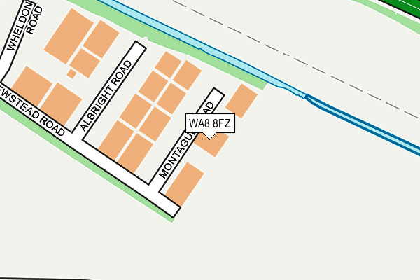
WA8 8FZ lies on Montague Road in Widnes. WA8 8FZ is located in the Ditton, Hale Village & Halebank electoral ward, within the unitary authority of Halton and the English Parliamentary constituency of Halton. The Sub Integrated Care Board (ICB) Location is NHS Cheshire and Merseyside ICB - 01F and the police force is Cheshire. This postcode has been in use since December 2005.


GetTheData
Source: OS OpenMap – Local (Ordnance Survey)
Source: OS VectorMap District (Ordnance Survey)
Licence: Open Government Licence (requires attribution)
| Easting | 348112 |
| Northing | 384900 |
| Latitude | 53.358434 |
| Longitude | -2.781094 |
GetTheData
Source: Open Postcode Geo
Licence: Open Government Licence
| Street | Montague Road |
| Town/City | Widnes |
| Country | England |
| Postcode District | WA8 |
| ➜ WA8 open data dashboard ➜ See where WA8 is on a map | |
GetTheData
Source: Land Registry Price Paid Data
Licence: Open Government Licence
Elevation or altitude of WA8 8FZ as distance above sea level:
| Metres | Feet | |
|---|---|---|
| Elevation | 10m | 33ft |
Elevation is measured from the approximate centre of the postcode, to the nearest point on an OS contour line from OS Terrain 50, which has contour spacing of ten vertical metres.
➜ How high above sea level am I? Find the elevation of your current position using your device's GPS.
GetTheData
Source: Open Postcode Elevation
Licence: Open Government Licence
| Ward | Ditton, Hale Village & Halebank |
| Constituency | Halton |
GetTheData
Source: ONS Postcode Database
Licence: Open Government Licence
| June 2022 | Robbery | On or near Albright Road | 82m |
| June 2022 | Anti-social behaviour | On or near A562 | 426m |
| March 2022 | Anti-social behaviour | On or near Albright Road | 82m |
| ➜ Get more crime data in our Crime section | |||
GetTheData
Source: data.police.uk
Licence: Open Government Licence
| County Boundary (Speke Road) | Halewood | 352m |
| County Boundary (Speke Road) | Halewood | 369m |
| Bee Hive (Hale Bank Road) | Ditton | 715m |
| Cottages (Hale Bank Road) | Ditton | 723m |
| Bee Hive (Hale Bank Road) | Ditton | 731m |
| Hough Green Station | 1.6km |
| Halewood Station | 3.3km |
| Runcorn Station | 3.5km |
GetTheData
Source: NaPTAN
Licence: Open Government Licence
Estimated total energy consumption in WA8 8FZ by fuel type, 2015.
| Consumption (kWh) | 200,592 |
|---|---|
| Meter count | 7 |
| Mean (kWh/meter) | 28,656 |
| Median (kWh/meter) | 17,366 |
GetTheData
Source: Postcode level gas estimates: 2015 (experimental)
Source: Postcode level electricity estimates: 2015 (experimental)
Licence: Open Government Licence
GetTheData
Source: ONS Postcode Database
Licence: Open Government Licence


➜ Get more ratings from the Food Standards Agency
GetTheData
Source: Food Standards Agency
Licence: FSA terms & conditions
| Last Collection | |||
|---|---|---|---|
| Location | Mon-Fri | Sat | Distance |
| Merseyview Road | 16:00 | 11:00 | 1,128m |
| Arklow Drive | 16:45 | 12:00 | 2,824m |
| Hale Post Office | 16:30 | 12:00 | 2,855m |
GetTheData
Source: Dracos
Licence: Creative Commons Attribution-ShareAlike
| Facility | Distance |
|---|---|
| Halebank Recreation Ground Blackburne Avenue, Widnes Grass Pitches | 734m |
| Optimum Fitness (Closed) Everite Road Industrial Estate, Westgate, Widnes Health and Fitness Gym, Studio | 738m |
| St Michaels Catholic Primary School St Michaels Road, Widnes Grass Pitches | 1.1km |
GetTheData
Source: Active Places
Licence: Open Government Licence
| School | Phase of Education | Distance |
|---|---|---|
| Our Lady of Perpetual Succour Catholic Primary School Clincton View, Widnes, WA8 8JN | Primary | 817m |
| Halebank CofE Primary School Heathview Road, Halebank, Widnes, WA8 8UZ | Primary | 963m |
| Oakfield Community Primary School Edinburgh Road, Widnes, WA8 8BQ | Primary | 1.1km |
GetTheData
Source: Edubase
Licence: Open Government Licence
The below table lists the International Territorial Level (ITL) codes (formerly Nomenclature of Territorial Units for Statistics (NUTS) codes) and Local Administrative Units (LAU) codes for WA8 8FZ:
| ITL 1 Code | Name |
|---|---|
| TLD | North West (England) |
| ITL 2 Code | Name |
| TLD7 | Merseyside |
| ITL 3 Code | Name |
| TLD71 | East Merseyside |
| LAU 1 Code | Name |
| E06000006 | Halton |
GetTheData
Source: ONS Postcode Directory
Licence: Open Government Licence
The below table lists the Census Output Area (OA), Lower Layer Super Output Area (LSOA), and Middle Layer Super Output Area (MSOA) for WA8 8FZ:
| Code | Name | |
|---|---|---|
| OA | E00170537 | |
| LSOA | E01012391 | Halton 008B |
| MSOA | E02002581 | Halton 008 |
GetTheData
Source: ONS Postcode Directory
Licence: Open Government Licence
| WA8 8GH | Ashwood Close | 537m |
| WA8 8RQ | Lakeside Close | 604m |
| WA8 8RH | Lakeside Close | 612m |
| WA8 8GE | Brackenwood Drive | 635m |
| WA8 8RW | Clincton View | 640m |
| WA8 8RA | Everite Road Industrial Estate | 658m |
| WA8 8RN | Clincton View | 682m |
| WA8 8NH | Halebank Road | 701m |
| WA8 8UN | Clapgate Crescent | 709m |
| WA8 8UP | Clapgate Crescent | 718m |
GetTheData
Source: Open Postcode Geo; Land Registry Price Paid Data
Licence: Open Government Licence