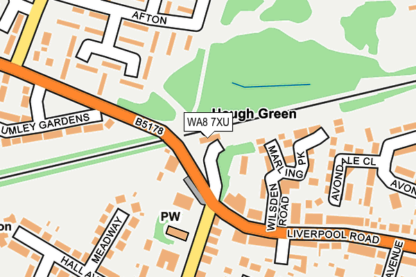
WA8 7XU is located in the Bankfield electoral ward, within the unitary authority of Halton and the English Parliamentary constituency of Halton. The Sub Integrated Care Board (ICB) Location is NHS Cheshire and Merseyside ICB - 01F and the police force is Cheshire. This postcode has been in use since January 1980.


GetTheData
Source: OS OpenMap – Local (Ordnance Survey)
Source: OS VectorMap District (Ordnance Survey)
Licence: Open Government Licence (requires attribution)
| Easting | 348525 |
| Northing | 386457 |
| Latitude | 53.372452 |
| Longitude | -2.775142 |
GetTheData
Source: Open Postcode Geo
Licence: Open Government Licence
| Country | England |
| Postcode District | WA8 |
| ➜ WA8 open data dashboard ➜ See where WA8 is on a map ➜ Where is Widnes? | |
GetTheData
Source: Land Registry Price Paid Data
Licence: Open Government Licence
Elevation or altitude of WA8 7XU as distance above sea level:
| Metres | Feet | |
|---|---|---|
| Elevation | 20m | 66ft |
Elevation is measured from the approximate centre of the postcode, to the nearest point on an OS contour line from OS Terrain 50, which has contour spacing of ten vertical metres.
➜ How high above sea level am I? Find the elevation of your current position using your device's GPS.
GetTheData
Source: Open Postcode Elevation
Licence: Open Government Licence
| Ward | Bankfield |
| Constituency | Halton |
GetTheData
Source: ONS Postcode Database
Licence: Open Government Licence
| September 2023 | Violence and sexual offences | On or near Arley Drive | 486m |
| September 2023 | Public order | On or near Arley Drive | 486m |
| August 2023 | Violence and sexual offences | On or near Arley Drive | 486m |
| ➜ Get more crime data in our Crime section | |||
GetTheData
Source: data.police.uk
Licence: Open Government Licence
| Hough Green Station (Liverpool Road) | Ditton | 128m |
| Hough Green Station (Liverpool Road) | Ditton | 198m |
| Hall Avenue (Ditchfield Road) | Ditton | 226m |
| Hall Avenue (Ditchfield Road) | Ditton | 288m |
| Crawford Avenue (Liverpool Road) | Ditton | 290m |
| Hough Green Station | 0km |
| Widnes Station | 2.8km |
| Halewood Station | 3.8km |
GetTheData
Source: NaPTAN
Licence: Open Government Licence
GetTheData
Source: ONS Postcode Database
Licence: Open Government Licence


➜ Get more ratings from the Food Standards Agency
GetTheData
Source: Food Standards Agency
Licence: FSA terms & conditions
| Last Collection | |||
|---|---|---|---|
| Location | Mon-Fri | Sat | Distance |
| Merseyview Road | 16:00 | 11:00 | 2,600m |
| Appleton Village | 17:30 | 11:00 | 2,851m |
| Blackhorse Post Office | 18:00 | 12:00 | 2,852m |
GetTheData
Source: Dracos
Licence: Creative Commons Attribution-ShareAlike
| Facility | Distance |
|---|---|
| Hough Green Park Royal Avenue, Widnes Outdoor Tennis Courts, Grass Pitches | 308m |
| Arley Drive Playing Fields Arley Drive, Widnes Grass Pitches | 399m |
| Upton Community Centre Hough Green Road, Widnes Sports Hall | 687m |
GetTheData
Source: Active Places
Licence: Open Government Licence
| School | Phase of Education | Distance |
|---|---|---|
| St Michael with St Thomas CE Primary School Spinney Avenue, Hough Green, Widnes, WA8 8LD | Primary | 409m |
| St Basil's Catholic Primary School Hough Green Road, Hough Green, Widnes, WA8 4SZ | Primary | 544m |
| Oakfield Community Primary School Edinburgh Road, Widnes, WA8 8BQ | Primary | 552m |
GetTheData
Source: Edubase
Licence: Open Government Licence
The below table lists the International Territorial Level (ITL) codes (formerly Nomenclature of Territorial Units for Statistics (NUTS) codes) and Local Administrative Units (LAU) codes for WA8 7XU:
| ITL 1 Code | Name |
|---|---|
| TLD | North West (England) |
| ITL 2 Code | Name |
| TLD7 | Merseyside |
| ITL 3 Code | Name |
| TLD71 | East Merseyside |
| LAU 1 Code | Name |
| E06000006 | Halton |
GetTheData
Source: ONS Postcode Directory
Licence: Open Government Licence
The below table lists the Census Output Area (OA), Lower Layer Super Output Area (LSOA), and Middle Layer Super Output Area (MSOA) for WA8 7XU:
| Code | Name | |
|---|---|---|
| OA | E00062438 | |
| LSOA | E01012377 | Halton 004A |
| MSOA | E02002577 | Halton 004 |
GetTheData
Source: ONS Postcode Directory
Licence: Open Government Licence
| WA8 7XS | Wilsden Road | 110m |
| WA8 7YE | Marling Park | 126m |
| WA8 8XR | Ditchfield Road | 172m |
| WA8 4XP | Afton | 193m |
| WA8 7XR | Liverpool Road | 196m |
| WA8 8XT | Meadway | 202m |
| WA8 7XP | Liverpool Road | 223m |
| WA8 4XR | Afton | 230m |
| WA8 4XG | Liverpool Road | 255m |
| WA8 4XF | Hough Green Road | 276m |
GetTheData
Source: Open Postcode Geo; Land Registry Price Paid Data
Licence: Open Government Licence