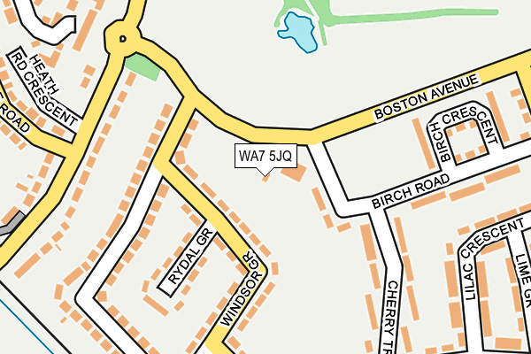
WA7 5JQ is located in the Grange electoral ward, within the unitary authority of Halton and the English Parliamentary constituency of Halton. The Sub Integrated Care Board (ICB) Location is NHS Cheshire and Merseyside ICB - 01F and the police force is Cheshire. This postcode has been in use since January 1980.


GetTheData
Source: OS OpenMap – Local (Ordnance Survey)
Source: OS VectorMap District (Ordnance Survey)
Licence: Open Government Licence (requires attribution)
| Easting | 351913 |
| Northing | 381852 |
| Latitude | 53.331398 |
| Longitude | -2.723524 |
GetTheData
Source: Open Postcode Geo
Licence: Open Government Licence
| Country | England |
| Postcode District | WA7 |
| ➜ WA7 open data dashboard ➜ See where WA7 is on a map ➜ Where is Runcorn? | |
GetTheData
Source: Land Registry Price Paid Data
Licence: Open Government Licence
Elevation or altitude of WA7 5JQ as distance above sea level:
| Metres | Feet | |
|---|---|---|
| Elevation | 40m | 131ft |
Elevation is measured from the approximate centre of the postcode, to the nearest point on an OS contour line from OS Terrain 50, which has contour spacing of ten vertical metres.
➜ How high above sea level am I? Find the elevation of your current position using your device's GPS.
GetTheData
Source: Open Postcode Elevation
Licence: Open Government Licence
| Ward | Grange |
| Constituency | Halton |
GetTheData
Source: ONS Postcode Database
Licence: Open Government Licence
| September 2023 | Violence and sexual offences | On or near Whitby Road | 439m |
| July 2023 | Vehicle crime | On or near Whitby Road | 439m |
| May 2023 | Violence and sexual offences | On or near Whitby Road | 439m |
| ➜ Get more crime data in our Crime section | |||
GetTheData
Source: data.police.uk
Licence: Open Government Licence
| Red Admiral (Boston Avenue) | Runcorn | 152m |
| Windsor Grove | Grange | 165m |
| Windsor Grove | Grange | 167m |
| Festival Way (Boston Avenue) | Runcorn | 173m |
| Red Admiral (Boston Avenue) | Runcorn | 179m |
| Runcorn Station | 1.3km |
| Runcorn East Station | 3.9km |
| Frodsham Station | 4km |
GetTheData
Source: NaPTAN
Licence: Open Government Licence
GetTheData
Source: ONS Postcode Database
Licence: Open Government Licence


➜ Get more ratings from the Food Standards Agency
GetTheData
Source: Food Standards Agency
Licence: FSA terms & conditions
| Last Collection | |||
|---|---|---|---|
| Location | Mon-Fri | Sat | Distance |
| Boston Avenue | 17:30 | 11:00 | 165m |
| Langdale Road | 17:30 | 11:00 | 445m |
| Grange S.o. | 17:30 | 11:15 | 491m |
GetTheData
Source: Dracos
Licence: Creative Commons Attribution-ShareAlike
| Facility | Distance |
|---|---|
| Pewithall Primary School Kenilworth Avenue, Runcorn Grass Pitches | 506m |
| Grange Academy Latham Avenue, Runcorn Sports Hall, Studio, Artificial Grass Pitch, Grass Pitches | 564m |
| Grange Comprehensive School (Closed) Latham Avenue, Runcorn Health and Fitness Gym, Grass Pitches, Sports Hall, Studio, Outdoor Tennis Courts | 661m |
GetTheData
Source: Active Places
Licence: Open Government Licence
| School | Phase of Education | Distance |
|---|---|---|
| Pewithall School Kenilworth avenue, Runcorn, WA7 4XQ | Primary | 517m |
| Halton Lodge Primary School Grangeway, Runcorn, WA7 5LU | Primary | 644m |
| St Clement's Catholic Primary School Oxford Road, Runcorn, WA7 4NX | Primary | 668m |
GetTheData
Source: Edubase
Licence: Open Government Licence
The below table lists the International Territorial Level (ITL) codes (formerly Nomenclature of Territorial Units for Statistics (NUTS) codes) and Local Administrative Units (LAU) codes for WA7 5JQ:
| ITL 1 Code | Name |
|---|---|
| TLD | North West (England) |
| ITL 2 Code | Name |
| TLD7 | Merseyside |
| ITL 3 Code | Name |
| TLD71 | East Merseyside |
| LAU 1 Code | Name |
| E06000006 | Halton |
GetTheData
Source: ONS Postcode Directory
Licence: Open Government Licence
The below table lists the Census Output Area (OA), Lower Layer Super Output Area (LSOA), and Middle Layer Super Output Area (MSOA) for WA7 5JQ:
| Code | Name | |
|---|---|---|
| OA | E00062542 | |
| LSOA | E01012397 | Halton 013C |
| MSOA | E02002586 | Halton 013 |
GetTheData
Source: ONS Postcode Directory
Licence: Open Government Licence
| WA7 5EP | Windsor Grove | 57m |
| WA7 5EW | Rydal Grove | 151m |
| WA7 5ER | Norleane Crescent | 162m |
| WA7 5EN | Windsor Grove | 187m |
| WA7 5JJ | Cherry Tree Avenue | 199m |
| WA7 5TF | Heath Road | 207m |
| WA7 5JL | Birch Road | 225m |
| WA7 5TG | Heath Road | 253m |
| WA7 5JX | Lilac Crescent | 259m |
| WA7 5ES | Norleane Crescent | 262m |
GetTheData
Source: Open Postcode Geo; Land Registry Price Paid Data
Licence: Open Government Licence