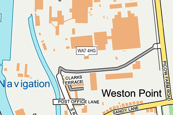
WA7 4HG is located in the Mersey & Weston electoral ward, within the unitary authority of Halton and the English Parliamentary constituency of Halton. The Sub Integrated Care Board (ICB) Location is NHS Cheshire and Merseyside ICB - 01F and the police force is Cheshire. This postcode has been in use since February 2011.


GetTheData
Source: OS OpenMap – Local (Ordnance Survey)
Source: OS VectorMap District (Ordnance Survey)
Licence: Open Government Licence (requires attribution)
| Easting | 349736 |
| Northing | 381568 |
| Latitude | 53.328643 |
| Longitude | -2.756165 |
GetTheData
Source: Open Postcode Geo
Licence: Open Government Licence
| Country | England |
| Postcode District | WA7 |
| ➜ WA7 open data dashboard ➜ See where WA7 is on a map ➜ Where is Runcorn? | |
GetTheData
Source: Land Registry Price Paid Data
Licence: Open Government Licence
Elevation or altitude of WA7 4HG as distance above sea level:
| Metres | Feet | |
|---|---|---|
| Elevation | 10m | 33ft |
Elevation is measured from the approximate centre of the postcode, to the nearest point on an OS contour line from OS Terrain 50, which has contour spacing of ten vertical metres.
➜ How high above sea level am I? Find the elevation of your current position using your device's GPS.
GetTheData
Source: Open Postcode Elevation
Licence: Open Government Licence
| Ward | Mersey & Weston |
| Constituency | Halton |
GetTheData
Source: ONS Postcode Database
Licence: Open Government Licence
| June 2022 | Vehicle crime | On or near Mersey View | 130m |
| June 2022 | Violence and sexual offences | On or near Sandy Lane | 365m |
| June 2022 | Violence and sexual offences | On or near Sandy Lane | 365m |
| ➜ Get more crime data in our Crime section | |||
GetTheData
Source: data.police.uk
Licence: Open Government Licence
| South Parade | Weston Point | 211m |
| South Parade | Weston Point | 222m |
| Weaver Hotel (Sandy Lane) | Weston Point | 240m |
| Weaver Hotel (South Parade) | Weston Point | 273m |
| Sandy Lane | Weston Point | 290m |
| Runcorn Station | 1.6km |
| Frodsham Station | 4.2km |
| Hough Green Station | 5km |
GetTheData
Source: NaPTAN
Licence: Open Government Licence
GetTheData
Source: ONS Postcode Database
Licence: Open Government Licence


➜ Get more ratings from the Food Standards Agency
GetTheData
Source: Food Standards Agency
Licence: FSA terms & conditions
| Last Collection | |||
|---|---|---|---|
| Location | Mon-Fri | Sat | Distance |
| Castner Avenue | 17:30 | 11:30 | 479m |
| South Parade | 16:00 | 11:00 | 479m |
| Weston Court | 17:30 | 11:00 | 905m |
GetTheData
Source: Dracos
Licence: Creative Commons Attribution-ShareAlike
| Facility | Distance |
|---|---|
| Viridor Community Stadium Sandy Lane, Weston Point, Runcorn Grass Pitches | 428m |
| Weston Point Community Primary School Castner Avenue, Weston Point, Runcorn Grass Pitches | 657m |
| Runcorn Hill Park Highlands Road, Runcorn Outdoor Tennis Courts | 1.1km |
GetTheData
Source: Active Places
Licence: Open Government Licence
| School | Phase of Education | Distance |
|---|---|---|
| Weston Point Primary Academy Castner Avenue, Weston Point, Runcorn, WA7 4EQ | Primary | 657m |
| Weston Point College Picow Farm Road, Runcorn, WA7 4UN | Not applicable | 832m |
| Westfield Primary School Clayton Crescent, Runcorn, WA7 4TR | Primary | 1.1km |
GetTheData
Source: Edubase
Licence: Open Government Licence
The below table lists the International Territorial Level (ITL) codes (formerly Nomenclature of Territorial Units for Statistics (NUTS) codes) and Local Administrative Units (LAU) codes for WA7 4HG:
| ITL 1 Code | Name |
|---|---|
| TLD | North West (England) |
| ITL 2 Code | Name |
| TLD7 | Merseyside |
| ITL 3 Code | Name |
| TLD71 | East Merseyside |
| LAU 1 Code | Name |
| E06000006 | Halton |
GetTheData
Source: ONS Postcode Directory
Licence: Open Government Licence
The below table lists the Census Output Area (OA), Lower Layer Super Output Area (LSOA), and Middle Layer Super Output Area (MSOA) for WA7 4HG:
| Code | Name | |
|---|---|---|
| OA | E00062629 | |
| LSOA | E01012417 | Halton 012B |
| MSOA | E02002585 | Halton 012 |
GetTheData
Source: ONS Postcode Directory
Licence: Open Government Licence
| WA7 4HD | Clarks Terrace | 101m |
| WA7 4HE | Beacon Hill View | 136m |
| WA7 4HA | Mersey View | 137m |
| WA7 4EX | Sandy Lane | 205m |
| WA7 4EY | South Road | 211m |
| WA7 4EU | Sandy Lane | 243m |
| WA7 4HT | South Parade | 292m |
| WA7 4HU | Baker Road | 297m |
| WA7 4HY | Cullen Road | 359m |
| WA7 4HX | Allen Road | 365m |
GetTheData
Source: Open Postcode Geo; Land Registry Price Paid Data
Licence: Open Government Licence