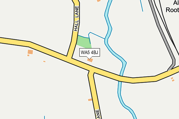
WA5 4BJ is located in the Burtonwood and Winwick electoral ward, within the unitary authority of Warrington and the English Parliamentary constituency of Warrington North. The Sub Integrated Care Board (ICB) Location is NHS Cheshire and Merseyside ICB - 02E and the police force is Cheshire. This postcode has been in use since January 1980.


GetTheData
Source: OS OpenMap – Local (Ordnance Survey)
Source: OS VectorMap District (Ordnance Survey)
Licence: Open Government Licence (requires attribution)
| Easting | 358490 |
| Northing | 392963 |
| Latitude | 53.431807 |
| Longitude | -2.626236 |
GetTheData
Source: Open Postcode Geo
Licence: Open Government Licence
| Country | England |
| Postcode District | WA5 |
➜ See where WA5 is on a map | |
GetTheData
Source: Land Registry Price Paid Data
Licence: Open Government Licence
Elevation or altitude of WA5 4BJ as distance above sea level:
| Metres | Feet | |
|---|---|---|
| Elevation | 10m | 33ft |
Elevation is measured from the approximate centre of the postcode, to the nearest point on an OS contour line from OS Terrain 50, which has contour spacing of ten vertical metres.
➜ How high above sea level am I? Find the elevation of your current position using your device's GPS.
GetTheData
Source: Open Postcode Elevation
Licence: Open Government Licence
| Ward | Burtonwood And Winwick |
| Constituency | Warrington North |
GetTheData
Source: ONS Postcode Database
Licence: Open Government Licence
| Fiddle In Bag (Alder Lane) | Burtonwood | 29m |
| Fiddle In Bag (Alder Lane) | Burtonwood | 46m |
| Coopers Farm (Alder Lane) | Burtonwood | 401m |
| Coopers Farm (Alder Lane) | Burtonwood | 452m |
| Alder Root Lane (Alder Lane) | Winwick | 574m |
| Earlestown Station | 2.3km |
| Newton-le-Willows Station | 2.5km |
| Sankey for Penketh Station | 4.7km |
GetTheData
Source: NaPTAN
Licence: Open Government Licence
GetTheData
Source: ONS Postcode Database
Licence: Open Government Licence


➜ Get more ratings from the Food Standards Agency
GetTheData
Source: Food Standards Agency
Licence: FSA terms & conditions
| Last Collection | |||
|---|---|---|---|
| Location | Mon-Fri | Sat | Distance |
| Vulcan | 17:00 | 11:00 | 919m |
| Bradlegh Road | 16:45 | 11:00 | 1,268m |
| Toys R Us | 18:00 | 11:00 | 1,620m |
GetTheData
Source: Dracos
Licence: Creative Commons Attribution-ShareAlike
| Risk of WA5 4BJ flooding from rivers and sea | Medium |
| ➜ WA5 4BJ flood map | |
GetTheData
Source: Open Flood Risk by Postcode
Licence: Open Government Licence
The below table lists the International Territorial Level (ITL) codes (formerly Nomenclature of Territorial Units for Statistics (NUTS) codes) and Local Administrative Units (LAU) codes for WA5 4BJ:
| ITL 1 Code | Name |
|---|---|
| TLD | North West (England) |
| ITL 2 Code | Name |
| TLD6 | Cheshire |
| ITL 3 Code | Name |
| TLD61 | Warrington |
| LAU 1 Code | Name |
| E06000007 | Warrington |
GetTheData
Source: ONS Postcode Directory
Licence: Open Government Licence
The below table lists the Census Output Area (OA), Lower Layer Super Output Area (LSOA), and Middle Layer Super Output Area (MSOA) for WA5 4BJ:
| Code | Name | |
|---|---|---|
| OA | E00062877 | |
| LSOA | E01012469 | Warrington 003C |
| MSOA | E02002592 | Warrington 003 |
GetTheData
Source: ONS Postcode Directory
Licence: Open Government Licence
| WA5 4BP | Alder Lane | 392m |
| WA12 8SD | Manchester Row | 823m |
| WA12 8SA | Liverpool Row | 899m |
| WA12 8SU | Hey Lock Close | 949m |
| WA12 8SX | Kirkacre Avenue | 955m |
| WA5 4BU | Alder Lane | 972m |
| WA12 8ST | Heywood Close | 992m |
| WA12 8SR | Conroy Way | 1012m |
| WA12 8SP | Tyrer Road | 1057m |
| WA12 8SS | Linear View | 1060m |
GetTheData
Source: Open Postcode Geo; Land Registry Price Paid Data
Licence: Open Government Licence