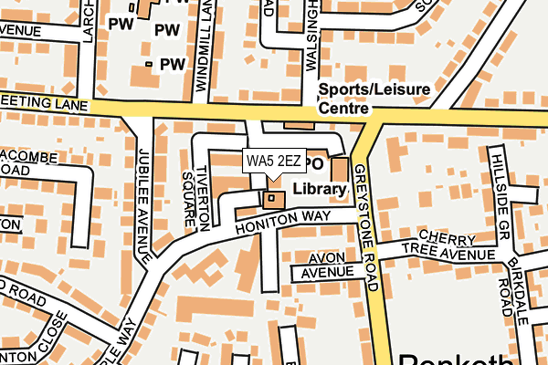
WA5 2EZ is located in the Penketh and Cuerdley electoral ward, within the unitary authority of Warrington and the English Parliamentary constituency of Warrington South. The Sub Integrated Care Board (ICB) Location is NHS Cheshire and Merseyside ICB - 02E and the police force is Cheshire. This postcode has been in use since January 1980.


GetTheData
Source: OS OpenMap – Local (Ordnance Survey)
Source: OS VectorMap District (Ordnance Survey)
Licence: Open Government Licence (requires attribution)
| Easting | 356465 |
| Northing | 387971 |
| Latitude | 53.386775 |
| Longitude | -2.656021 |
GetTheData
Source: Open Postcode Geo
Licence: Open Government Licence
| Country | England |
| Postcode District | WA5 |
| ➜ WA5 open data dashboard ➜ See where WA5 is on a map ➜ Where is Warrington? | |
GetTheData
Source: Land Registry Price Paid Data
Licence: Open Government Licence
Elevation or altitude of WA5 2EZ as distance above sea level:
| Metres | Feet | |
|---|---|---|
| Elevation | 10m | 33ft |
Elevation is measured from the approximate centre of the postcode, to the nearest point on an OS contour line from OS Terrain 50, which has contour spacing of ten vertical metres.
➜ How high above sea level am I? Find the elevation of your current position using your device's GPS.
GetTheData
Source: Open Postcode Elevation
Licence: Open Government Licence
| Ward | Penketh And Cuerdley |
| Constituency | Warrington South |
GetTheData
Source: ONS Postcode Database
Licence: Open Government Licence
| June 2022 | Violence and sexual offences | On or near William Penn Close | 55m |
| June 2022 | Anti-social behaviour | On or near William Penn Close | 55m |
| June 2022 | Vehicle crime | On or near Walsingham Road | 196m |
| ➜ Get more crime data in our Crime section | |||
GetTheData
Source: data.police.uk
Licence: Open Government Licence
| Shops (Honiton Way) | Penketh | 52m |
| Shops (Honiton Way) | Penketh | 59m |
| Honiton Way Shops (Greystone Road) | Penketh | 83m |
| Conservative Club (Meeting Lane) | Penketh | 84m |
| Honiton Way Shops (Greystone Road) | Penketh | 100m |
| Sankey for Penketh Station | 0.7km |
| Warrington Bank Quay Station | 3.6km |
| Warrington Central Station | 4.2km |
GetTheData
Source: NaPTAN
Licence: Open Government Licence
GetTheData
Source: ONS Postcode Database
Licence: Open Government Licence


➜ Get more ratings from the Food Standards Agency
GetTheData
Source: Food Standards Agency
Licence: FSA terms & conditions
| Last Collection | |||
|---|---|---|---|
| Location | Mon-Fri | Sat | Distance |
| Maple Crescent | 16:00 | 11:00 | 520m |
| Crown & Cushion | 17:15 | 11:00 | 631m |
| Great Sankey S.o. | 17:30 | 12:00 | 636m |
GetTheData
Source: Dracos
Licence: Creative Commons Attribution-ShareAlike
| Facility | Distance |
|---|---|
| Penketh Health & Fitness Club (Closed) Honiton Way, Penketh, Warrington Health and Fitness Gym | 14m |
| Penketh Youth Centre Honiton Way, Penketh, Warrington Sports Hall | 45m |
| Penketh Parish Council Pool & Community Centre Honiton Way, Penketh, Warrington Sports Hall, Swimming Pool | 47m |
GetTheData
Source: Active Places
Licence: Open Government Licence
| School | Phase of Education | Distance |
|---|---|---|
| St Joseph's Catholic Primary School Walton Avenue, Penketh, St Joseph's Catholic Primary School, Warrington, WA5 2AU | Primary | 357m |
| Penketh Primary School Coniston Avenue, Penketh, Warrington, WA5 2QY | Primary | 504m |
| Penketh High School Heath Road, Penketh, Warrington, WA5 2BY | Secondary | 574m |
GetTheData
Source: Edubase
Licence: Open Government Licence
The below table lists the International Territorial Level (ITL) codes (formerly Nomenclature of Territorial Units for Statistics (NUTS) codes) and Local Administrative Units (LAU) codes for WA5 2EZ:
| ITL 1 Code | Name |
|---|---|
| TLD | North West (England) |
| ITL 2 Code | Name |
| TLD6 | Cheshire |
| ITL 3 Code | Name |
| TLD61 | Warrington |
| LAU 1 Code | Name |
| E06000007 | Warrington |
GetTheData
Source: ONS Postcode Directory
Licence: Open Government Licence
The below table lists the Census Output Area (OA), Lower Layer Super Output Area (LSOA), and Middle Layer Super Output Area (MSOA) for WA5 2EZ:
| Code | Name | |
|---|---|---|
| OA | E00063196 | |
| LSOA | E01012532 | Warrington 019F |
| MSOA | E02002608 | Warrington 019 |
GetTheData
Source: ONS Postcode Directory
Licence: Open Government Licence
| WA5 2EY | Honiton Way | 24m |
| WA5 2HB | Helston Close | 59m |
| WA5 2EX | Avon Avenue | 91m |
| WA5 2HA | Tiverton Square | 96m |
| WA5 2BE | Meeting Lane | 97m |
| WA5 2BD | Meeting Lane | 121m |
| WA5 2AF | Walsingham Road | 128m |
| WA5 2DS | Greystone Road | 130m |
| WA5 2BG | Meeting Lane | 138m |
| WA5 2AE | Walsingham Road | 149m |
GetTheData
Source: Open Postcode Geo; Land Registry Price Paid Data
Licence: Open Government Licence