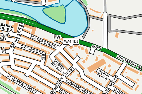
WA4 1DJ lies on Carol Street in Latchford, Warrington. WA4 1DJ is located in the Latchford West electoral ward, within the unitary authority of Warrington and the English Parliamentary constituency of Warrington South. The Sub Integrated Care Board (ICB) Location is NHS Cheshire and Merseyside ICB - 02E and the police force is Cheshire. This postcode has been in use since June 1981.


GetTheData
Source: OS OpenMap – Local (Ordnance Survey)
Source: OS VectorMap District (Ordnance Survey)
Licence: Open Government Licence (requires attribution)
| Easting | 361646 |
| Northing | 387514 |
| Latitude | 53.383087 |
| Longitude | -2.578072 |
GetTheData
Source: Open Postcode Geo
Licence: Open Government Licence
| Street | Carol Street |
| Locality | Latchford |
| Town/City | Warrington |
| Country | England |
| Postcode District | WA4 |
➜ See where WA4 is on a map ➜ Where is Warrington? | |
GetTheData
Source: Land Registry Price Paid Data
Licence: Open Government Licence
Elevation or altitude of WA4 1DJ as distance above sea level:
| Metres | Feet | |
|---|---|---|
| Elevation | 10m | 33ft |
Elevation is measured from the approximate centre of the postcode, to the nearest point on an OS contour line from OS Terrain 50, which has contour spacing of ten vertical metres.
➜ How high above sea level am I? Find the elevation of your current position using your device's GPS.
GetTheData
Source: Open Postcode Elevation
Licence: Open Government Licence
| Ward | Latchford West |
| Constituency | Warrington South |
GetTheData
Source: ONS Postcode Database
Licence: Open Government Licence
| Grove Street (Knutsford Road) | Latchford | 169m |
| Victoria Park (Knutsford Road) | Latchford | 182m |
| Grove Street (Knutsford Road) | Latchford | 204m |
| Park Avenue (Knutsford Road) | Latchford | 210m |
| St Mary's Street (Knutsford Road) | Latchford | 481m |
| Warrington Central Station | 1.4km |
| Warrington Bank Quay Station | 1.6km |
| Padgate Station | 2.9km |
GetTheData
Source: NaPTAN
Licence: Open Government Licence
| Percentage of properties with Next Generation Access | 100.0% |
| Percentage of properties with Superfast Broadband | 100.0% |
| Percentage of properties with Ultrafast Broadband | 100.0% |
| Percentage of properties with Full Fibre Broadband | 0.0% |
Superfast Broadband is between 30Mbps and 300Mbps
Ultrafast Broadband is > 300Mbps
| Percentage of properties unable to receive 2Mbps | 0.0% |
| Percentage of properties unable to receive 5Mbps | 0.0% |
| Percentage of properties unable to receive 10Mbps | 0.0% |
| Percentage of properties unable to receive 30Mbps | 0.0% |
GetTheData
Source: Ofcom
Licence: Ofcom Terms of Use (requires attribution)
GetTheData
Source: ONS Postcode Database
Licence: Open Government Licence


➜ Get more ratings from the Food Standards Agency
GetTheData
Source: Food Standards Agency
Licence: FSA terms & conditions
| Last Collection | |||
|---|---|---|---|
| Location | Mon-Fri | Sat | Distance |
| Shrewsbury Street | 16:40 | 11:00 | 136m |
| Knutsford Road S.o. | 17:30 | 12:00 | 217m |
| Wharf Green | 17:30 | 11:00 | 305m |
GetTheData
Source: Dracos
Licence: Creative Commons Attribution-ShareAlike
| Risk of WA4 1DJ flooding from rivers and sea | Low |
| ➜ WA4 1DJ flood map | |
GetTheData
Source: Open Flood Risk by Postcode
Licence: Open Government Licence
The below table lists the International Territorial Level (ITL) codes (formerly Nomenclature of Territorial Units for Statistics (NUTS) codes) and Local Administrative Units (LAU) codes for WA4 1DJ:
| ITL 1 Code | Name |
|---|---|
| TLD | North West (England) |
| ITL 2 Code | Name |
| TLD6 | Cheshire |
| ITL 3 Code | Name |
| TLD61 | Warrington |
| LAU 1 Code | Name |
| E06000007 | Warrington |
GetTheData
Source: ONS Postcode Directory
Licence: Open Government Licence
The below table lists the Census Output Area (OA), Lower Layer Super Output Area (LSOA), and Middle Layer Super Output Area (MSOA) for WA4 1DJ:
| Code | Name | |
|---|---|---|
| OA | E00063095 | |
| LSOA | E01012511 | Warrington 017E |
| MSOA | E02002606 | Warrington 017 |
GetTheData
Source: ONS Postcode Directory
Licence: Open Government Licence
| WA4 1DP | Florence Street | 67m |
| WA4 1DW | Slater Street | 79m |
| WA4 1DR | Beatrice Street | 79m |
| WA4 1HE | Surrey Street | 80m |
| WA4 1HF | Shrewsbury Street | 112m |
| WA4 1DU | Knutsford Road | 140m |
| WA4 1DN | Slater Street | 144m |
| WA4 1EZ | Cumberland Street | 147m |
| WA4 1HD | Oxford Street | 164m |
| WA4 1ED | Evans Place | 168m |
GetTheData
Source: Open Postcode Geo; Land Registry Price Paid Data
Licence: Open Government Licence