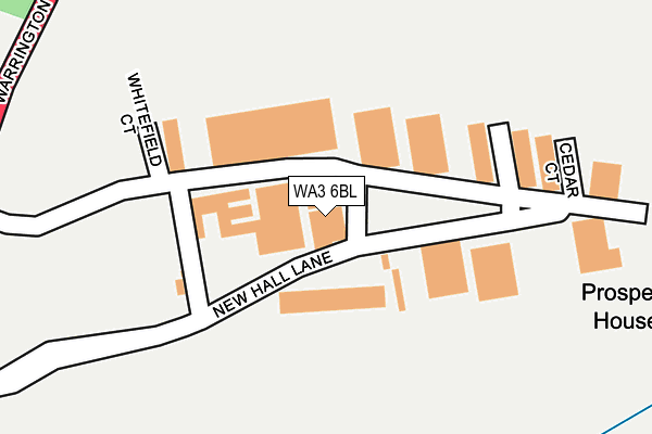
WA3 6BL is located in the Culcheth, Glazebury and Croft electoral ward, within the unitary authority of Warrington and the English Parliamentary constituency of Warrington North. The Sub Integrated Care Board (ICB) Location is NHS Cheshire and Merseyside ICB - 02E and the police force is Cheshire. This postcode has been in use since January 1980.


GetTheData
Source: OS OpenMap – Local (Ordnance Survey)
Source: OS VectorMap District (Ordnance Survey)
Licence: Open Government Licence (requires attribution)
| Easting | 365716 |
| Northing | 394448 |
| Latitude | 53.445675 |
| Longitude | -2.517644 |
GetTheData
Source: Open Postcode Geo
Licence: Open Government Licence
| Country | England |
| Postcode District | WA3 |
| ➜ WA3 open data dashboard ➜ See where WA3 is on a map | |
GetTheData
Source: Land Registry Price Paid Data
Licence: Open Government Licence
Elevation or altitude of WA3 6BL as distance above sea level:
| Metres | Feet | |
|---|---|---|
| Elevation | 30m | 98ft |
Elevation is measured from the approximate centre of the postcode, to the nearest point on an OS contour line from OS Terrain 50, which has contour spacing of ten vertical metres.
➜ How high above sea level am I? Find the elevation of your current position using your device's GPS.
GetTheData
Source: Open Postcode Elevation
Licence: Open Government Licence
| Ward | Culcheth, Glazebury And Croft |
| Constituency | Warrington North |
GetTheData
Source: ONS Postcode Database
Licence: Open Government Licence
| June 2022 | Anti-social behaviour | On or near Greenwood Close | 170m |
| June 2022 | Other theft | On or near New Hall Lane | 190m |
| June 2022 | Violence and sexual offences | On or near Downham Avenue | 347m |
| ➜ Get more crime data in our Crime section | |||
GetTheData
Source: data.police.uk
Licence: Open Government Licence
| Taylor Business Park (Warrington Road) | Culcheth | 322m |
| Newchurch Lane (Warrington Road) | Culcheth | 441m |
| Newchurch Lane (Warrington Road) | Culcheth | 463m |
| Chatburn Court (Warrington Road) | Culcheth | 580m |
| Library (Warrington Road) | Culcheth | 758m |
| Birchwood Station | 3.7km |
| Glazebrook Station | 4.3km |
| Padgate Station | 5.1km |
GetTheData
Source: NaPTAN
Licence: Open Government Licence
| Median download speed | 12.7Mbps |
| Average download speed | 12.9Mbps |
| Maximum download speed | 21.71Mbps |
| Median upload speed | 0.9Mbps |
| Average upload speed | 0.9Mbps |
| Maximum upload speed | 1.22Mbps |
GetTheData
Source: Ofcom
Licence: Ofcom Terms of Use (requires attribution)
GetTheData
Source: ONS Postcode Database
Licence: Open Government Licence


➜ Get more ratings from the Food Standards Agency
GetTheData
Source: Food Standards Agency
Licence: FSA terms & conditions
| Last Collection | |||
|---|---|---|---|
| Location | Mon-Fri | Sat | Distance |
| Taylor Ind Estate | 16:00 | 11:00 | 504m |
| Kaye Avenue | 17:00 | 08:30 | 510m |
| Culcheth S.o. | 17:30 | 12:00 | 811m |
GetTheData
Source: Dracos
Licence: Creative Commons Attribution-ShareAlike
| Facility | Distance |
|---|---|
| The Oaks Warrington Road, Risley, Warrington Grass Pitches | 462m |
| Newchurch Community Primary School Glebeland, Culcheth, Warrington Sports Hall, Grass Pitches | 504m |
| Culcheth Sports Club Charnock Road, Culcheth, Warrington Grass Pitches, Sports Hall, Outdoor Tennis Courts | 732m |
GetTheData
Source: Active Places
Licence: Open Government Licence
| School | Phase of Education | Distance |
|---|---|---|
| Newchurch Community Primary School Glebeland, Culcheth, Warrington, WA3 4DX | Primary | 508m |
| Culcheth High School Warrington Road, Culcheth, Warrington, WA3 5HH | Secondary | 1.1km |
| Culcheth Community Primary School Warrington Road, Culcheth, Warrington, WA3 5HH | Primary | 1.1km |
GetTheData
Source: Edubase
Licence: Open Government Licence
The below table lists the International Territorial Level (ITL) codes (formerly Nomenclature of Territorial Units for Statistics (NUTS) codes) and Local Administrative Units (LAU) codes for WA3 6BL:
| ITL 1 Code | Name |
|---|---|
| TLD | North West (England) |
| ITL 2 Code | Name |
| TLD6 | Cheshire |
| ITL 3 Code | Name |
| TLD61 | Warrington |
| LAU 1 Code | Name |
| E06000007 | Warrington |
GetTheData
Source: ONS Postcode Directory
Licence: Open Government Licence
The below table lists the Census Output Area (OA), Lower Layer Super Output Area (LSOA), and Middle Layer Super Output Area (MSOA) for WA3 6BL:
| Code | Name | |
|---|---|---|
| OA | E00173172 | |
| LSOA | E01012471 | Warrington 001A |
| MSOA | E02002590 | Warrington 001 |
GetTheData
Source: ONS Postcode Directory
Licence: Open Government Licence
| WA3 5RS | Crossfield Avenue | 275m |
| WA3 5RU | Downham Avenue | 329m |
| WA3 5EB | Severn Road | 348m |
| WA3 5RR | Newchurch Lane | 352m |
| WA3 5AD | Warrington Road | 354m |
| WA3 5ED | Severn Road | 379m |
| WA3 5RT | Newchurch Lane | 382m |
| WA3 5RP | Newchurch Lane | 383m |
| WA3 5RW | Newchurch Lane | 404m |
| WA3 5EA | Ribble Close | 407m |
GetTheData
Source: Open Postcode Geo; Land Registry Price Paid Data
Licence: Open Government Licence