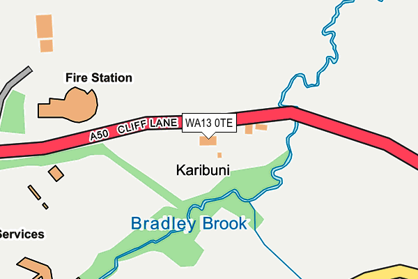
WA13 0TE lies on Cliff Lane in Lymm. WA13 0TE is located in the Lymm South electoral ward, within the unitary authority of Warrington and the English Parliamentary constituency of Warrington South. The Sub Integrated Care Board (ICB) Location is NHS Cheshire and Merseyside ICB - 02E and the police force is Cheshire. This postcode has been in use since January 1980.


GetTheData
Source: OS OpenMap – Local (Ordnance Survey)
Source: OS VectorMap District (Ordnance Survey)
Licence: Open Government Licence (requires attribution)
| Easting | 366867 |
| Northing | 384902 |
| Latitude | 53.359964 |
| Longitude | -2.499309 |
GetTheData
Source: Open Postcode Geo
Licence: Open Government Licence
| Street | Cliff Lane |
| Town/City | Lymm |
| Country | England |
| Postcode District | WA13 |
| ➜ WA13 open data dashboard ➜ See where WA13 is on a map | |
GetTheData
Source: Land Registry Price Paid Data
Licence: Open Government Licence
Elevation or altitude of WA13 0TE as distance above sea level:
| Metres | Feet | |
|---|---|---|
| Elevation | 50m | 164ft |
Elevation is measured from the approximate centre of the postcode, to the nearest point on an OS contour line from OS Terrain 50, which has contour spacing of ten vertical metres.
➜ How high above sea level am I? Find the elevation of your current position using your device's GPS.
GetTheData
Source: Open Postcode Elevation
Licence: Open Government Licence
| Ward | Lymm South |
| Constituency | Warrington South |
GetTheData
Source: ONS Postcode Database
Licence: Open Government Licence
| January 2024 | Vehicle crime | On or near Petrol Station | 486m |
| January 2024 | Drugs | On or near Petrol Station | 486m |
| January 2024 | Shoplifting | On or near Petrol Station | 486m |
| ➜ Cliff Lane crime map and outcomes | |||
GetTheData
Source: data.police.uk
Licence: Open Government Licence
| Poplar 2000 Services (Off Cliff Lane) | Statham | 498m |
| Howshoots Roundabout (Grappenhall Lane) | Statham | 1,080m |
GetTheData
Source: NaPTAN
Licence: Open Government Licence
| Percentage of properties with Next Generation Access | 100.0% |
| Percentage of properties with Superfast Broadband | 0.0% |
| Percentage of properties with Ultrafast Broadband | 0.0% |
| Percentage of properties with Full Fibre Broadband | 0.0% |
Superfast Broadband is between 30Mbps and 300Mbps
Ultrafast Broadband is > 300Mbps
| Percentage of properties unable to receive 2Mbps | 0.0% |
| Percentage of properties unable to receive 5Mbps | 0.0% |
| Percentage of properties unable to receive 10Mbps | 0.0% |
| Percentage of properties unable to receive 30Mbps | 100.0% |
GetTheData
Source: Ofcom
Licence: Ofcom Terms of Use (requires attribution)
GetTheData
Source: ONS Postcode Database
Licence: Open Government Licence


➜ Get more ratings from the Food Standards Agency
GetTheData
Source: Food Standards Agency
Licence: FSA terms & conditions
| Last Collection | |||
|---|---|---|---|
| Location | Mon-Fri | Sat | Distance |
| Lymm Service Station | 16:00 | 07:15 | 377m |
| Cherry Lane | 16:10 | 07:45 | 459m |
| Booths Lane | 17:00 | 11:00 | 1,759m |
GetTheData
Source: Dracos
Licence: Creative Commons Attribution-ShareAlike
| Facility | Distance |
|---|---|
| Cherry Tree Primary School Hardy Road, Lymm Grass Pitches, Athletics | 1.9km |
| Lymm Rfc Crouchley Lane, Lymm Grass Pitches, Squash Courts, Artificial Grass Pitch, Outdoor Tennis Courts | 2.2km |
| High Legh Tennis Club Warrington Road, High Legh Outdoor Tennis Courts | 2.2km |
GetTheData
Source: Active Places
Licence: Open Government Licence
| School | Phase of Education | Distance |
|---|---|---|
| Bright Futures Willow Tree Park, Beech House, Booths Lane, Lymm, WA13 0GH | Not applicable | 1.9km |
| Cherry Tree School Hardy Road, Lymm, Warrington, WA13 0NX | Primary | 2km |
| Statham Primary School Warrington Road, Statham, Lymm, WA13 9BE | Primary | 2.7km |
GetTheData
Source: Edubase
Licence: Open Government Licence
The below table lists the International Territorial Level (ITL) codes (formerly Nomenclature of Territorial Units for Statistics (NUTS) codes) and Local Administrative Units (LAU) codes for WA13 0TE:
| ITL 1 Code | Name |
|---|---|
| TLD | North West (England) |
| ITL 2 Code | Name |
| TLD6 | Cheshire |
| ITL 3 Code | Name |
| TLD61 | Warrington |
| LAU 1 Code | Name |
| E06000007 | Warrington |
GetTheData
Source: ONS Postcode Directory
Licence: Open Government Licence
The below table lists the Census Output Area (OA), Lower Layer Super Output Area (LSOA), and Middle Layer Super Output Area (MSOA) for WA13 0TE:
| Code | Name | |
|---|---|---|
| OA | E00063123 | |
| LSOA | E01012515 | Warrington 021C |
| MSOA | E02002610 | Warrington 021 |
GetTheData
Source: ONS Postcode Directory
Licence: Open Government Licence
| WA16 0SG | Withers Lane | 365m |
| WA13 0TB | Cherry Corner | 398m |
| WA13 0TA | Cherry Lane | 457m |
| WA13 0SZ | Cherry Lane | 538m |
| WA16 0SF | Withers Lane | 928m |
| WA16 0RZ | Fanners Lane | 1071m |
| WA4 4SL | Cliff Lane | 1095m |
| WA16 0SH | Warrington Road | 1109m |
| WA13 0SY | Cherry Lane | 1143m |
| WA16 0SB | Swineyard Lane | 1152m |
GetTheData
Source: Open Postcode Geo; Land Registry Price Paid Data
Licence: Open Government Licence