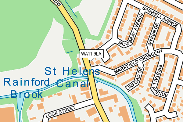
WA11 9LA is located in the Blackbrook electoral ward, within the metropolitan district of St. Helens and the English Parliamentary constituency of St Helens North. The Sub Integrated Care Board (ICB) Location is NHS Cheshire and Merseyside ICB - 01X and the police force is Merseyside. This postcode has been in use since January 1980.


GetTheData
Source: OS OpenMap – Local (Ordnance Survey)
Source: OS VectorMap District (Ordnance Survey)
Licence: Open Government Licence (requires attribution)
| Easting | 352218 |
| Northing | 396395 |
| Latitude | 53.462137 |
| Longitude | -2.721150 |
GetTheData
Source: Open Postcode Geo
Licence: Open Government Licence
| Country | England |
| Postcode District | WA11 |
| ➜ WA11 open data dashboard ➜ See where WA11 is on a map ➜ Where is St Helens? | |
GetTheData
Source: Land Registry Price Paid Data
Licence: Open Government Licence
Elevation or altitude of WA11 9LA as distance above sea level:
| Metres | Feet | |
|---|---|---|
| Elevation | 30m | 98ft |
Elevation is measured from the approximate centre of the postcode, to the nearest point on an OS contour line from OS Terrain 50, which has contour spacing of ten vertical metres.
➜ How high above sea level am I? Find the elevation of your current position using your device's GPS.
GetTheData
Source: Open Postcode Elevation
Licence: Open Government Licence
| Ward | Blackbrook |
| Constituency | St Helens North |
GetTheData
Source: ONS Postcode Database
Licence: Open Government Licence
| January 2024 | Anti-social behaviour | On or near Grantham Crescent | 257m |
| January 2024 | Violence and sexual offences | On or near Grantham Crescent | 257m |
| December 2023 | Criminal damage and arson | On or near Grantham Crescent | 257m |
| ➜ Get more crime data in our Crime section | |||
GetTheData
Source: data.police.uk
Licence: Open Government Licence
| Mowbray Avenue (Hinckley Road) | Laffak | 85m |
| Mowbray Avenue (Hinckley Road) | Laffak | 125m |
| Merton Street (Merton Bank Road) | Pocket Nook | 234m |
| Bosworth Road | Laffak | 298m |
| Hinckley Road (Bosworth Road) | Laffak | 314m |
| St Helens Central Station | 1.2km |
| St Helens Junction Station | 3.5km |
| Thatto Heath Station | 3.8km |
GetTheData
Source: NaPTAN
Licence: Open Government Licence
| Percentage of properties with Next Generation Access | 100.0% |
| Percentage of properties with Superfast Broadband | 100.0% |
| Percentage of properties with Ultrafast Broadband | 100.0% |
| Percentage of properties with Full Fibre Broadband | 0.0% |
Superfast Broadband is between 30Mbps and 300Mbps
Ultrafast Broadband is > 300Mbps
| Percentage of properties unable to receive 2Mbps | 0.0% |
| Percentage of properties unable to receive 5Mbps | 0.0% |
| Percentage of properties unable to receive 10Mbps | 0.0% |
| Percentage of properties unable to receive 30Mbps | 0.0% |
GetTheData
Source: Ofcom
Licence: Ofcom Terms of Use (requires attribution)
GetTheData
Source: ONS Postcode Database
Licence: Open Government Licence


➜ Get more ratings from the Food Standards Agency
GetTheData
Source: Food Standards Agency
Licence: FSA terms & conditions
| Last Collection | |||
|---|---|---|---|
| Location | Mon-Fri | Sat | Distance |
| Central Av/ St Helens Road | 17:30 | 12:00 | 423m |
| Higher Parr Street Post Office | 18:00 | 12:00 | 950m |
| Blackbrook Road Post Office | 17:00 | 11:00 | 1,009m |
GetTheData
Source: Dracos
Licence: Creative Commons Attribution-ShareAlike
| Facility | Distance |
|---|---|
| Merton Bank Playing Fields Merton Bank Road, St. Helens Grass Pitches | 498m |
| Merton Bank Primary School Roper Street, St. Helens Grass Pitches | 623m |
| Haresfinch Arlfc Haresfinch Road, St. Helens Grass Pitches | 630m |
GetTheData
Source: Active Places
Licence: Open Government Licence
| School | Phase of Education | Distance |
|---|---|---|
| Merton Bank Primary School Roper Street, St Helens, WA9 1EJ | Primary | 624m |
| Parish Church of England Primary School, St Helens Charles Street, St Helens, WA10 1LW | Primary | 882m |
| Ashurst Primary School New Glade Hill, Off Chain Lane, Blackbrook, St Helens, WA11 9QJ | Primary | 901m |
GetTheData
Source: Edubase
Licence: Open Government Licence
The below table lists the International Territorial Level (ITL) codes (formerly Nomenclature of Territorial Units for Statistics (NUTS) codes) and Local Administrative Units (LAU) codes for WA11 9LA:
| ITL 1 Code | Name |
|---|---|
| TLD | North West (England) |
| ITL 2 Code | Name |
| TLD7 | Merseyside |
| ITL 3 Code | Name |
| TLD71 | East Merseyside |
| LAU 1 Code | Name |
| E08000013 | St. Helens |
GetTheData
Source: ONS Postcode Directory
Licence: Open Government Licence
The below table lists the Census Output Area (OA), Lower Layer Super Output Area (LSOA), and Middle Layer Super Output Area (MSOA) for WA11 9LA:
| Code | Name | |
|---|---|---|
| OA | E00034546 | |
| LSOA | E01006814 | St. Helens 008E |
| MSOA | E02001413 | St. Helens 008 |
GetTheData
Source: ONS Postcode Directory
Licence: Open Government Licence
| WA11 9HX | Measham Close | 58m |
| WA11 9HU | Hinckley Road | 63m |
| WA11 9LD | Markfield Crescent | 101m |
| WA9 1HZ | Merton Bank Road | 133m |
| WA11 9LE | Linford Grove | 147m |
| WA11 9JD | Mowbray Avenue | 149m |
| WA11 9HY | Hinckley Road | 155m |
| WA11 9JA | Wyken Grove | 202m |
| WA11 9JB | Barwell Avenue | 230m |
| WA11 9LF | Birstall Avenue | 235m |
GetTheData
Source: Open Postcode Geo; Land Registry Price Paid Data
Licence: Open Government Licence