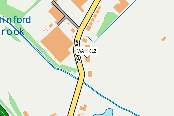
WA11 8LZ is located in the Rainford electoral ward, within the metropolitan district of St. Helens and the English Parliamentary constituency of St Helens North. The Sub Integrated Care Board (ICB) Location is NHS Cheshire and Merseyside ICB - 01X and the police force is Merseyside. This postcode has been in use since December 1996.


GetTheData
Source: OS OpenMap – Local (Ordnance Survey)
Source: OS VectorMap District (Ordnance Survey)
Licence: Open Government Licence (requires attribution)
| Easting | 349036 |
| Northing | 399264 |
| Latitude | 53.487623 |
| Longitude | -2.769540 |
GetTheData
Source: Open Postcode Geo
Licence: Open Government Licence
| Country | England |
| Postcode District | WA11 |
➜ See where WA11 is on a map | |
GetTheData
Source: Land Registry Price Paid Data
Licence: Open Government Licence
Elevation or altitude of WA11 8LZ as distance above sea level:
| Metres | Feet | |
|---|---|---|
| Elevation | 30m | 98ft |
Elevation is measured from the approximate centre of the postcode, to the nearest point on an OS contour line from OS Terrain 50, which has contour spacing of ten vertical metres.
➜ How high above sea level am I? Find the elevation of your current position using your device's GPS.
GetTheData
Source: Open Postcode Elevation
Licence: Open Government Licence
| Ward | Rainford |
| Constituency | St Helens North |
GetTheData
Source: ONS Postcode Database
Licence: Open Government Licence
| Sandwash Close (Mill Lane) | Rainford | 285m |
| St Helens Road | Hill Top | 401m |
| Mill Lane (St Helens Road) | Hill Top | 422m |
| Bottle And Glass (St Helens Road) | Hill Top | 642m |
| Rainford By-pass (Pasture Lane) | Rainford | 644m |
| Rainford Station | 3.5km |
| St Helens Central Station | 4.6km |
| Upholland Station | 4.9km |
GetTheData
Source: NaPTAN
Licence: Open Government Licence
Estimated total energy consumption in WA11 8LZ by fuel type, 2015.
| Consumption (kWh) | 87,889 |
|---|---|
| Meter count | 6 |
| Mean (kWh/meter) | 14,648 |
| Median (kWh/meter) | 18,280 |
GetTheData
Source: Postcode level gas estimates: 2015 (experimental)
Source: Postcode level electricity estimates: 2015 (experimental)
Licence: Open Government Licence
GetTheData
Source: ONS Postcode Database
Licence: Open Government Licence


➜ Get more ratings from the Food Standards Agency
GetTheData
Source: Food Standards Agency
Licence: FSA terms & conditions
| Last Collection | |||
|---|---|---|---|
| Location | Mon-Fri | Sat | Distance |
| Mill Lane | 16:00 | 08:00 | 344m |
| Heyes Avenue | 16:00 | 09:30 | 1,177m |
| Rainford Post Office | 17:30 | 12:00 | 1,642m |
GetTheData
Source: Dracos
Licence: Creative Commons Attribution-ShareAlike
| Risk of WA11 8LZ flooding from rivers and sea | Medium |
| ➜ WA11 8LZ flood map | |
GetTheData
Source: Open Flood Risk by Postcode
Licence: Open Government Licence
The below table lists the International Territorial Level (ITL) codes (formerly Nomenclature of Territorial Units for Statistics (NUTS) codes) and Local Administrative Units (LAU) codes for WA11 8LZ:
| ITL 1 Code | Name |
|---|---|
| TLD | North West (England) |
| ITL 2 Code | Name |
| TLD7 | Merseyside |
| ITL 3 Code | Name |
| TLD71 | East Merseyside |
| LAU 1 Code | Name |
| E08000013 | St. Helens |
GetTheData
Source: ONS Postcode Directory
Licence: Open Government Licence
The below table lists the Census Output Area (OA), Lower Layer Super Output Area (LSOA), and Middle Layer Super Output Area (MSOA) for WA11 8LZ:
| Code | Name | |
|---|---|---|
| OA | E00034903 | |
| LSOA | E01006885 | St. Helens 001D |
| MSOA | E02001406 | St. Helens 001 |
GetTheData
Source: ONS Postcode Directory
Licence: Open Government Licence
| WA11 8LW | Mill Lane | 146m |
| WA11 8ND | Mill Lane | 377m |
| WA11 8GH | The Manor | 434m |
| WA11 8AA | Meadow View | 519m |
| WA11 7QX | St Helens Road | 529m |
| WA11 8PT | Pasture Lane | 577m |
| WA11 8LY | Sandwash Close | 592m |
| WA11 7QR | St Helens Road | 694m |
| WA11 7QS | Hill Top Road | 717m |
| WA11 7QA | Berringtons Lane | 787m |
GetTheData
Source: Open Postcode Geo; Land Registry Price Paid Data
Licence: Open Government Licence