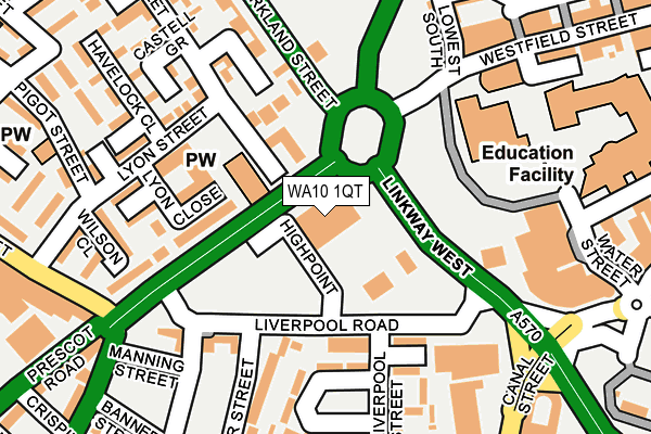
WA10 1QT is located in the St Helens Town Centre electoral ward, within the metropolitan district of St. Helens and the English Parliamentary constituency of St Helens South and Whiston. The Sub Integrated Care Board (ICB) Location is NHS Cheshire and Merseyside ICB - 01X and the police force is Merseyside. This postcode has been in use since May 2015.


GetTheData
Source: OS OpenMap – Local (Ordnance Survey)
Source: OS VectorMap District (Ordnance Survey)
Licence: Open Government Licence (requires attribution)
| Easting | 350708 |
| Northing | 395272 |
| Latitude | 53.451904 |
| Longitude | -2.743715 |
GetTheData
Source: Open Postcode Geo
Licence: Open Government Licence
| Country | England |
| Postcode District | WA10 |
| ➜ WA10 open data dashboard ➜ See where WA10 is on a map ➜ Where is St Helens? | |
GetTheData
Source: Land Registry Price Paid Data
Licence: Open Government Licence
Elevation or altitude of WA10 1QT as distance above sea level:
| Metres | Feet | |
|---|---|---|
| Elevation | 30m | 98ft |
Elevation is measured from the approximate centre of the postcode, to the nearest point on an OS contour line from OS Terrain 50, which has contour spacing of ten vertical metres.
➜ How high above sea level am I? Find the elevation of your current position using your device's GPS.
GetTheData
Source: Open Postcode Elevation
Licence: Open Government Licence
| Ward | St Helens Town Centre |
| Constituency | St Helens South And Whiston |
GetTheData
Source: ONS Postcode Database
Licence: Open Government Licence
| January 2024 | Criminal damage and arson | On or near Parking Area | 458m |
| January 2024 | Public order | On or near Parking Area | 458m |
| January 2024 | Public order | On or near Parking Area | 458m |
| ➜ Get more crime data in our Crime section | |||
GetTheData
Source: data.police.uk
Licence: Open Government Licence
| Linkway West (Westfield Street) | Green Bank | 58m |
| Eccleston Street (Westfield Street) | St Helens | 144m |
| Asda (Kirkland Street) | St Helens | 261m |
| Asda (Kirkland Street) | St Helens | 277m |
| Rigby Street South (Westfield Street) | St Helens | 306m |
| St Helens Central Station | 0.9km |
| Thatto Heath Station | 2km |
| Lea Green Station | 3.1km |
GetTheData
Source: NaPTAN
Licence: Open Government Licence
GetTheData
Source: ONS Postcode Database
Licence: Open Government Licence


➜ Get more ratings from the Food Standards Agency
GetTheData
Source: Food Standards Agency
Licence: FSA terms & conditions
| Last Collection | |||
|---|---|---|---|
| Location | Mon-Fri | Sat | Distance |
| Liverpool Road Business Box | 18:30 | 153m | |
| Liverpool Road Delivery Office | 18:30 | 12:30 | 157m |
| Bridge Street Post Office | 18:00 | 12:30 | 330m |
GetTheData
Source: Dracos
Licence: Creative Commons Attribution-ShareAlike
| Facility | Distance |
|---|---|
| The Gym Health And Fitness Water Street, St. Helens Health and Fitness Gym, Studio | 171m |
| St Helens College Sports Facilities (Closed) Water Street, St. Helens Sports Hall, Studio, Health and Fitness Gym, Artificial Grass Pitch, Grass Pitches | 177m |
| Everlast Gyms (St Helens) King Street, St Helens Health and Fitness Gym, Studio | 316m |
GetTheData
Source: Active Places
Licence: Open Government Licence
| School | Phase of Education | Distance |
|---|---|---|
| St Helens College Water Street, St Helens, WA10 1PP | 16 plus | 177m |
| St Mary & St Thomas' CofE Primary School Barton Close, St Helens, WA10 2HS | Primary | 359m |
| Launchpad Centre College Street, St Helens, WA10 1UH | Not applicable | 725m |
GetTheData
Source: Edubase
Licence: Open Government Licence
The below table lists the International Territorial Level (ITL) codes (formerly Nomenclature of Territorial Units for Statistics (NUTS) codes) and Local Administrative Units (LAU) codes for WA10 1QT:
| ITL 1 Code | Name |
|---|---|
| TLD | North West (England) |
| ITL 2 Code | Name |
| TLD7 | Merseyside |
| ITL 3 Code | Name |
| TLD71 | East Merseyside |
| LAU 1 Code | Name |
| E08000013 | St. Helens |
GetTheData
Source: ONS Postcode Directory
Licence: Open Government Licence
The below table lists the Census Output Area (OA), Lower Layer Super Output Area (LSOA), and Middle Layer Super Output Area (MSOA) for WA10 1QT:
| Code | Name | |
|---|---|---|
| OA | E00034622 | |
| LSOA | E01006832 | St. Helens 012A |
| MSOA | E02001417 | St. Helens 012 |
GetTheData
Source: ONS Postcode Directory
Licence: Open Government Licence
| WA10 2AZ | Abberley Close | 166m |
| WA10 1QP | Westfield Street | 181m |
| WA10 2EA | Castell Grove | 191m |
| WA10 2EL | Wilson Close | 192m |
| WA10 3LJ | Liverpool Street | 194m |
| WA10 3LH | Greenbank Crescent | 201m |
| WA10 2RA | Havelock Close | 220m |
| WA10 3LB | Bold Street | 222m |
| WA10 2RD | Lyon Street | 226m |
| WA10 1QJ | Westfield Street | 226m |
GetTheData
Source: Open Postcode Geo; Land Registry Price Paid Data
Licence: Open Government Licence