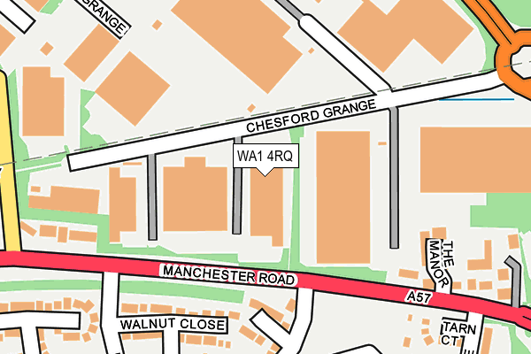
WA1 4RQ lies on Chesford Grange in Woolston, Warrington. WA1 4RQ is located in the Rixton and Woolston electoral ward, within the unitary authority of Warrington and the English Parliamentary constituency of Warrington North. The Sub Integrated Care Board (ICB) Location is NHS Cheshire and Merseyside ICB - 02E and the police force is Cheshire. This postcode has been in use since January 1980.


GetTheData
Source: OS OpenMap – Local (Ordnance Survey)
Source: OS VectorMap District (Ordnance Survey)
Licence: Open Government Licence (requires attribution)
| Easting | 365595 |
| Northing | 389351 |
| Latitude | 53.399855 |
| Longitude | -2.518908 |
GetTheData
Source: Open Postcode Geo
Licence: Open Government Licence
| Street | Chesford Grange |
| Locality | Woolston |
| Town/City | Warrington |
| Country | England |
| Postcode District | WA1 |
| ➜ WA1 open data dashboard ➜ See where WA1 is on a map ➜ Where is Warrington? | |
GetTheData
Source: Land Registry Price Paid Data
Licence: Open Government Licence
Elevation or altitude of WA1 4RQ as distance above sea level:
| Metres | Feet | |
|---|---|---|
| Elevation | 10m | 33ft |
Elevation is measured from the approximate centre of the postcode, to the nearest point on an OS contour line from OS Terrain 50, which has contour spacing of ten vertical metres.
➜ How high above sea level am I? Find the elevation of your current position using your device's GPS.
GetTheData
Source: Open Postcode Elevation
Licence: Open Government Licence
| Ward | Rixton And Woolston |
| Constituency | Warrington North |
GetTheData
Source: ONS Postcode Database
Licence: Open Government Licence
| September 2023 | Anti-social behaviour | On or near Lawson Close | 336m |
| August 2023 | Burglary | On or near Redwood Close | 382m |
| March 2023 | Violence and sexual offences | On or near Lawson Close | 336m |
| ➜ Chesford Grange crime map and outcomes | |||
GetTheData
Source: data.police.uk
Licence: Open Government Licence
| Weir Lane (Manchester Road) | Martinscroft | 167m |
| Gig Lane (Manchester Road) | Martinscroft | 225m |
| Riversdale (Manchester Road) | Martinscroft | 297m |
| Mawdsley Avenue (Gig Lane) | Martinscroft | 298m |
| Gig Lane (Manchester Road) | Martinscroft | 355m |
| Birchwood Station | 1.5km |
| Padgate Station | 2.6km |
| Warrington Central Station | 5km |
GetTheData
Source: NaPTAN
Licence: Open Government Licence
Estimated total energy consumption in WA1 4RQ by fuel type, 2015.
| Consumption (kWh) | 284,217 |
|---|---|
| Meter count | 7 |
| Mean (kWh/meter) | 40,602 |
| Median (kWh/meter) | 42,894 |
GetTheData
Source: Postcode level gas estimates: 2015 (experimental)
Source: Postcode level electricity estimates: 2015 (experimental)
Licence: Open Government Licence
GetTheData
Source: ONS Postcode Database
Licence: Open Government Licence


➜ Get more ratings from the Food Standards Agency
GetTheData
Source: Food Standards Agency
Licence: FSA terms & conditions
| Last Collection | |||
|---|---|---|---|
| Location | Mon-Fri | Sat | Distance |
| Manor Park | 17:30 | 11:00 | 360m |
| Hardwick Grange | 18:30 | 648m | |
| Woolston Grange | 17:00 | 11:00 | 662m |
GetTheData
Source: Dracos
Licence: Creative Commons Attribution-ShareAlike
| Facility | Distance |
|---|---|
| Woolston Neighbourhood Hub Hall Road, Woolston, Warrington Swimming Pool, Health and Fitness Gym, Grass Pitches, Squash Courts, Studio | 1km |
| Woolston Ce Aided Primary School Epping Drive, Woolston, Warrington Grass Pitches, Sports Hall | 1.1km |
| St Peters Primary School Hillock Lane, Woolston, Warrington Grass Pitches | 1.1km |
GetTheData
Source: Active Places
Licence: Open Government Licence
| School | Phase of Education | Distance |
|---|---|---|
| Woolston CofE Aided Primary School Epping Drive, Woolston, Warrington, WA1 4QL | Primary | 1.1km |
| St Peter's Catholic Primary School Hillock Lane, Woolston, Warrington, WA1 4PQ | Primary | 1.1km |
| Woolston Community Primary School Barnfield Road, Woolston, Warrington, WA1 4NW | Primary | 1.4km |
GetTheData
Source: Edubase
Licence: Open Government Licence
The below table lists the International Territorial Level (ITL) codes (formerly Nomenclature of Territorial Units for Statistics (NUTS) codes) and Local Administrative Units (LAU) codes for WA1 4RQ:
| ITL 1 Code | Name |
|---|---|
| TLD | North West (England) |
| ITL 2 Code | Name |
| TLD6 | Cheshire |
| ITL 3 Code | Name |
| TLD61 | Warrington |
| LAU 1 Code | Name |
| E06000007 | Warrington |
GetTheData
Source: ONS Postcode Directory
Licence: Open Government Licence
The below table lists the Census Output Area (OA), Lower Layer Super Output Area (LSOA), and Middle Layer Super Output Area (MSOA) for WA1 4RQ:
| Code | Name | |
|---|---|---|
| OA | E00063310 | |
| LSOA | E01012551 | Warrington 014A |
| MSOA | E02002603 | Warrington 014 |
GetTheData
Source: ONS Postcode Directory
Licence: Open Government Licence
| WA1 4QE | Clares Farm Close | 151m |
| WA1 4HA | Walnut Close | 179m |
| WA1 4SZ | Chesford Grange | 228m |
| WA1 4HS | Magnolia Close | 237m |
| WA1 4PS | Manchester Road | 239m |
| WA1 4QG | Martinscroft Green | 240m |
| WA1 4PU | Manchester Road | 247m |
| WA1 4RE | Chesford Grange | 265m |
| WA1 4QA | Tarn Court | 271m |
| WA1 4RN | Croftside | 281m |
GetTheData
Source: Open Postcode Geo; Land Registry Price Paid Data
Licence: Open Government Licence