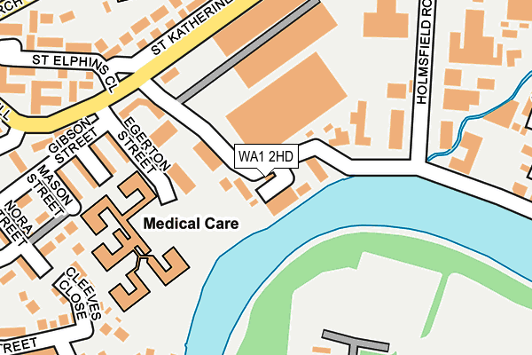
WA1 2HD is located in the Fairfield and Howley electoral ward, within the unitary authority of Warrington and the English Parliamentary constituency of Warrington North. The Sub Integrated Care Board (ICB) Location is NHS Cheshire and Merseyside ICB - 02E and the police force is Cheshire. This postcode has been in use since September 2015.


GetTheData
Source: OS OpenMap – Local (Ordnance Survey)
Source: OS VectorMap District (Ordnance Survey)
Licence: Open Government Licence (requires attribution)
| Easting | 361682 |
| Northing | 388182 |
| Latitude | 53.389093 |
| Longitude | -2.577613 |
GetTheData
Source: Open Postcode Geo
Licence: Open Government Licence
| Country | England |
| Postcode District | WA1 |
➜ See where WA1 is on a map ➜ Where is Warrington? | |
GetTheData
Source: Land Registry Price Paid Data
Licence: Open Government Licence
Elevation or altitude of WA1 2HD as distance above sea level:
| Metres | Feet | |
|---|---|---|
| Elevation | 10m | 33ft |
Elevation is measured from the approximate centre of the postcode, to the nearest point on an OS contour line from OS Terrain 50, which has contour spacing of ten vertical metres.
➜ How high above sea level am I? Find the elevation of your current position using your device's GPS.
GetTheData
Source: Open Postcode Elevation
Licence: Open Government Licence
| Ward | Fairfield And Howley |
| Constituency | Warrington North |
GetTheData
Source: ONS Postcode Database
Licence: Open Government Licence
| Parish Church (Church Street) | Howley | 320m |
| Sainsburys (Church Street) | Howley | 344m |
| St Elphin's Park (Manchester Road) | Howley | 491m |
| St Elphin's Park (Manchester Road) | Howley | 505m |
| Orchard Street (Church Street) | Howley | 510m |
| Warrington Central Station | 1.1km |
| Warrington Bank Quay Station | 1.7km |
| Padgate Station | 2.3km |
GetTheData
Source: NaPTAN
Licence: Open Government Licence
| Percentage of properties with Next Generation Access | 100.0% |
| Percentage of properties with Superfast Broadband | 100.0% |
| Percentage of properties with Ultrafast Broadband | 20.0% |
| Percentage of properties with Full Fibre Broadband | 0.0% |
Superfast Broadband is between 30Mbps and 300Mbps
Ultrafast Broadband is > 300Mbps
| Median download speed | 58.6Mbps |
| Average download speed | 61.9Mbps |
| Maximum download speed | 74.15Mbps |
| Median upload speed | 17.9Mbps |
| Average upload speed | 16.4Mbps |
| Maximum upload speed | 19.53Mbps |
| Percentage of properties unable to receive 2Mbps | 0.0% |
| Percentage of properties unable to receive 5Mbps | 0.0% |
| Percentage of properties unable to receive 10Mbps | 0.0% |
| Percentage of properties unable to receive 30Mbps | 0.0% |
GetTheData
Source: Ofcom
Licence: Ofcom Terms of Use (requires attribution)
GetTheData
Source: ONS Postcode Database
Licence: Open Government Licence


➜ Get more ratings from the Food Standards Agency
GetTheData
Source: Food Standards Agency
Licence: FSA terms & conditions
| Last Collection | |||
|---|---|---|---|
| Location | Mon-Fri | Sat | Distance |
| Howley Lane | 16:45 | 11:00 | 198m |
| Parr Street | 16:45 | 11:00 | 425m |
| Wharf Green | 17:30 | 11:00 | 457m |
GetTheData
Source: Dracos
Licence: Creative Commons Attribution-ShareAlike
| Risk of WA1 2HD flooding from rivers and sea | Low |
| ➜ WA1 2HD flood map | |
GetTheData
Source: Open Flood Risk by Postcode
Licence: Open Government Licence
The below table lists the International Territorial Level (ITL) codes (formerly Nomenclature of Territorial Units for Statistics (NUTS) codes) and Local Administrative Units (LAU) codes for WA1 2HD:
| ITL 1 Code | Name |
|---|---|
| TLD | North West (England) |
| ITL 2 Code | Name |
| TLD6 | Cheshire |
| ITL 3 Code | Name |
| TLD61 | Warrington |
| LAU 1 Code | Name |
| E06000007 | Warrington |
GetTheData
Source: ONS Postcode Directory
Licence: Open Government Licence
The below table lists the Census Output Area (OA), Lower Layer Super Output Area (LSOA), and Middle Layer Super Output Area (MSOA) for WA1 2HD:
| Code | Name | |
|---|---|---|
| OA | E00062963 | |
| LSOA | E01012480 | Warrington 017B |
| MSOA | E02002606 | Warrington 017 |
GetTheData
Source: ONS Postcode Directory
Licence: Open Government Licence
| WA1 2DJ | Howley Lane | 88m |
| WA1 2DF | Egerton Street | 170m |
| WA1 2DE | Gibson Street | 188m |
| WA1 2JL | Villars Street | 204m |
| WA1 2ER | St Katherines Way | 220m |
| WA1 2JJ | Mason Street | 226m |
| WA1 2JH | Cleeves Close | 237m |
| WA1 2ES | St Katherines Way | 249m |
| WA1 2JB | Nora Street | 261m |
| WA1 2EE | Farrell Street | 263m |
GetTheData
Source: Open Postcode Geo; Land Registry Price Paid Data
Licence: Open Government Licence