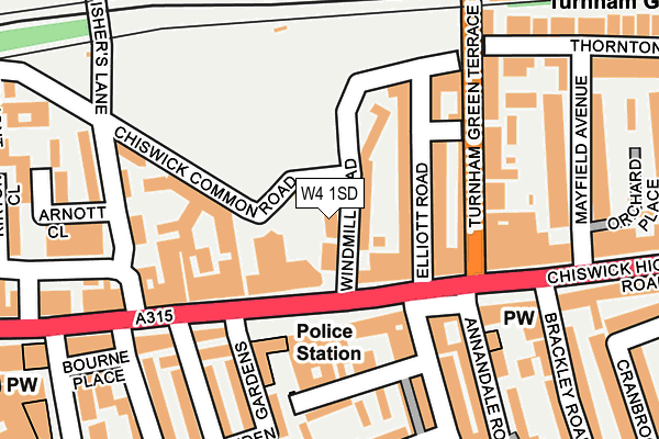
W4 1SD lies on Windmill Road in London. W4 1SD is located in the Chiswick Gunnersbury electoral ward, within the London borough of Hounslow and the English Parliamentary constituency of Brentford and Isleworth. The Sub Integrated Care Board (ICB) Location is NHS North West London ICB - W2U3Z and the police force is Metropolitan Police. This postcode has been in use since June 1981.


GetTheData
Source: OS OpenMap – Local (Ordnance Survey)
Source: OS VectorMap District (Ordnance Survey)
Licence: Open Government Licence (requires attribution)
| Easting | 521084 |
| Northing | 178586 |
| Latitude | 51.493261 |
| Longitude | -0.257234 |
GetTheData
Source: Open Postcode Geo
Licence: Open Government Licence
| Street | Windmill Road |
| Town/City | London |
| Country | England |
| Postcode District | W4 |
➜ See where W4 is on a map ➜ Where is Chiswick? | |
GetTheData
Source: Land Registry Price Paid Data
Licence: Open Government Licence
Elevation or altitude of W4 1SD as distance above sea level:
| Metres | Feet | |
|---|---|---|
| Elevation | 10m | 33ft |
Elevation is measured from the approximate centre of the postcode, to the nearest point on an OS contour line from OS Terrain 50, which has contour spacing of ten vertical metres.
➜ How high above sea level am I? Find the elevation of your current position using your device's GPS.
GetTheData
Source: Open Postcode Elevation
Licence: Open Government Licence
| Ward | Chiswick Gunnersbury |
| Constituency | Brentford And Isleworth |
GetTheData
Source: ONS Postcode Database
Licence: Open Government Licence
| Chiswick Police Station (Chiswick High Road) | Turnham Green | 54m |
| Chiswick Police Station (Chiswick High Road) | Turnham Green | 92m |
| Chardin Road (Turnham Green Terrace) | Turnham Green | 148m |
| Fishers Lane (Fisher's Lane) | Turnham Green | 184m |
| Chiswick Police Station (Chiswick High Road) | Turnham Green | 200m |
| Turnham Green Underground Station | Turnham Green | 280m |
| Chiswick Park Underground Station | Chiswick Park | 761m |
| Stamford Brook Underground Station | Stamford Brook | 821m |
| Gunnersbury Underground Station | Gunnersbury | 1,263m |
| Ravenscourt Park Underground Station | Ravenscourt Park | 1,486m |
| South Acton Station | 1.1km |
| Gunnersbury Station | 1.3km |
| Chiswick Station | 1.5km |
GetTheData
Source: NaPTAN
Licence: Open Government Licence
GetTheData
Source: ONS Postcode Database
Licence: Open Government Licence


➜ Get more ratings from the Food Standards Agency
GetTheData
Source: Food Standards Agency
Licence: FSA terms & conditions
| Last Collection | |||
|---|---|---|---|
| Location | Mon-Fri | Sat | Distance |
| Chiswick High Road | 18:30 | 12:00 | 108m |
| Chiswick High Road | 18:30 | 12:00 | 176m |
| Thornton Avenue | 18:30 | 12:00 | 202m |
GetTheData
Source: Dracos
Licence: Creative Commons Attribution-ShareAlike
| Risk of W4 1SD flooding from rivers and sea | Very Low |
| ➜ W4 1SD flood map | |
GetTheData
Source: Open Flood Risk by Postcode
Licence: Open Government Licence
The below table lists the International Territorial Level (ITL) codes (formerly Nomenclature of Territorial Units for Statistics (NUTS) codes) and Local Administrative Units (LAU) codes for W4 1SD:
| ITL 1 Code | Name |
|---|---|
| TLI | London |
| ITL 2 Code | Name |
| TLI7 | Outer London - West and North West |
| ITL 3 Code | Name |
| TLI75 | Hounslow and Richmond upon Thames |
| LAU 1 Code | Name |
| E09000018 | Hounslow |
GetTheData
Source: ONS Postcode Directory
Licence: Open Government Licence
The below table lists the Census Output Area (OA), Lower Layer Super Output Area (LSOA), and Middle Layer Super Output Area (MSOA) for W4 1SD:
| Code | Name | |
|---|---|---|
| OA | E00013348 | |
| LSOA | E01002693 | Hounslow 029D |
| MSOA | E02006792 | Hounslow 029 |
GetTheData
Source: ONS Postcode Directory
Licence: Open Government Licence
| W4 1SA | Windmill Road | 37m |
| W4 1RN | Windmill Road | 45m |
| W4 1PE | Elliott Road | 78m |
| W4 1PD | Chiswick High Road | 85m |
| W4 1PF | Elliott Road | 106m |
| W4 1RT | Castle Place | 109m |
| W4 2DR | Chiswick High Road | 116m |
| W4 1PP | Chiswick High Road | 117m |
| W4 1RG | Turnham Green Terrace | 121m |
| W4 1YA | Fishers Lane | 127m |
GetTheData
Source: Open Postcode Geo; Land Registry Price Paid Data
Licence: Open Government Licence