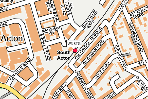
W3 8TG is located in the South Acton electoral ward, within the London borough of Ealing and the English Parliamentary constituency of Ealing Central and Acton. The Sub Integrated Care Board (ICB) Location is NHS North West London ICB - W2U3Z and the police force is Metropolitan Police. This postcode has been in use since December 1999.


GetTheData
Source: OS OpenMap – Local (Ordnance Survey)
Source: OS VectorMap District (Ordnance Survey)
Licence: Open Government Licence (requires attribution)
| Easting | 520171 |
| Northing | 179277 |
| Latitude | 51.499666 |
| Longitude | -0.270144 |
GetTheData
Source: Open Postcode Geo
Licence: Open Government Licence
| Country | England |
| Postcode District | W3 |
| ➜ W3 open data dashboard ➜ See where W3 is on a map ➜ Where is Acton? | |
GetTheData
Source: Land Registry Price Paid Data
Licence: Open Government Licence
Elevation or altitude of W3 8TG as distance above sea level:
| Metres | Feet | |
|---|---|---|
| Elevation | 10m | 33ft |
Elevation is measured from the approximate centre of the postcode, to the nearest point on an OS contour line from OS Terrain 50, which has contour spacing of ten vertical metres.
➜ How high above sea level am I? Find the elevation of your current position using your device's GPS.
GetTheData
Source: Open Postcode Elevation
Licence: Open Government Licence
| Ward | South Acton |
| Constituency | Ealing Central And Acton |
GetTheData
Source: ONS Postcode Database
Licence: Open Government Licence
| January 2024 | Vehicle crime | On or near Beaulieu Place | 207m |
| November 2023 | Burglary | On or near Beaulieu Place | 207m |
| September 2023 | Burglary | On or near Cunnington Street | 389m |
| ➜ Get more crime data in our Crime section | |||
GetTheData
Source: data.police.uk
Licence: Open Government Licence
| All Saints Road | South Acton | 255m |
| Newton Avenue (Bollo Bridge Road) | South Acton | 272m |
| Palmerston Road Stanley Road | South Acton | 281m |
| Stanhope Way Acton Works | Chiswick Park | 286m |
| Palmerston Road Stanley Road | South Acton | 291m |
| Chiswick Park Underground Station | Chiswick Park | 581m |
| Acton Town Underground Station | Acton Town | 809m |
| Gunnersbury Underground Station | Gunnersbury | 944m |
| Turnham Green Underground Station | Turnham Green | 1,193m |
| Ealing Common Underground Station | Ealing Common | 1,714m |
| South Acton Station | 0km |
| Gunnersbury Station | 1km |
| Acton Central Station | 1.1km |
GetTheData
Source: NaPTAN
Licence: Open Government Licence
GetTheData
Source: ONS Postcode Database
Licence: Open Government Licence


➜ Get more ratings from the Food Standards Agency
GetTheData
Source: Food Standards Agency
Licence: FSA terms & conditions
| Last Collection | |||
|---|---|---|---|
| Location | Mon-Fri | Sat | Distance |
| Kingswood Road | 17:30 | 12:00 | 162m |
| Bollo Bridge Road | 17:30 | 12:00 | 247m |
| 227 Acton Lane | 17:30 | 12:00 | 365m |
GetTheData
Source: Dracos
Licence: Creative Commons Attribution-ShareAlike
| Facility | Distance |
|---|---|
| Energie Fitness (Acton) Bollo Bridge Road, London Health and Fitness Gym | 276m |
| The Wellbeing Centre (Closed) Bollo Bridge Road, London Health and Fitness Gym, Sports Hall | 283m |
| Virgin Active (Chiswick Park) Chiswick High Road, Chiswick, London Swimming Pool, Health and Fitness Gym, Studio | 679m |
GetTheData
Source: Active Places
Licence: Open Government Licence
| School | Phase of Education | Distance |
|---|---|---|
| Acton Gardens Primary School Osborne Road, Acton, London, W3 8SJ | Primary | 432m |
| South Acton Childrens Centre Castle Close, Acton, London, W3 8RX | Nursery | 516m |
| Ark Priory Primary Academy Acton Lane, London, W3 8NR | Primary | 631m |
GetTheData
Source: Edubase
Licence: Open Government Licence
The below table lists the International Territorial Level (ITL) codes (formerly Nomenclature of Territorial Units for Statistics (NUTS) codes) and Local Administrative Units (LAU) codes for W3 8TG:
| ITL 1 Code | Name |
|---|---|
| TLI | London |
| ITL 2 Code | Name |
| TLI7 | Outer London - West and North West |
| ITL 3 Code | Name |
| TLI73 | Ealing |
| LAU 1 Code | Name |
| E09000009 | Ealing |
GetTheData
Source: ONS Postcode Directory
Licence: Open Government Licence
The below table lists the Census Output Area (OA), Lower Layer Super Output Area (LSOA), and Middle Layer Super Output Area (MSOA) for W3 8TG:
| Code | Name | |
|---|---|---|
| OA | E00166868 | |
| LSOA | E01001357 | Ealing 033D |
| MSOA | E02000270 | Ealing 033 |
GetTheData
Source: ONS Postcode Directory
Licence: Open Government Licence
| W3 8FG | All Saints Road | 16m |
| W4 5BA | Bridgman Road | 73m |
| W4 5BN | Kingswood Terrace | 74m |
| W3 8BF | Palmerston Road | 81m |
| W3 8BP | All Saints Road | 88m |
| W4 5BD | Bridgman Road | 88m |
| W3 8FF | Palmerston Road | 101m |
| W4 5ET | Kingswood Road | 125m |
| W4 5EZ | Kent Road | 127m |
| W3 8FE | Stanley Road | 130m |
GetTheData
Source: Open Postcode Geo; Land Registry Price Paid Data
Licence: Open Government Licence