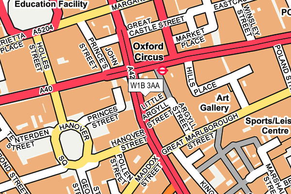
W1B 3AA is located in the West End electoral ward, within the London borough of Westminster and the English Parliamentary constituency of Cities of London and Westminster. The Sub Integrated Care Board (ICB) Location is NHS North West London ICB - W2U3Z and the police force is Metropolitan Police. This postcode has been in use since June 2001.


GetTheData
Source: OS OpenMap – Local (Ordnance Survey)
Source: OS VectorMap District (Ordnance Survey)
Licence: Open Government Licence (requires attribution)
| Easting | 529051 |
| Northing | 181174 |
| Latitude | 51.514759 |
| Longitude | -0.141590 |
GetTheData
Source: Open Postcode Geo
Licence: Open Government Licence
| Country | England |
| Postcode District | W1B |
| ➜ W1B open data dashboard ➜ See where W1B is on a map ➜ Where is City of Westminster? | |
GetTheData
Source: Land Registry Price Paid Data
Licence: Open Government Licence
Elevation or altitude of W1B 3AA as distance above sea level:
| Metres | Feet | |
|---|---|---|
| Elevation | 20m | 66ft |
Elevation is measured from the approximate centre of the postcode, to the nearest point on an OS contour line from OS Terrain 50, which has contour spacing of ten vertical metres.
➜ How high above sea level am I? Find the elevation of your current position using your device's GPS.
GetTheData
Source: Open Postcode Elevation
Licence: Open Government Licence
| Ward | West End |
| Constituency | Cities Of London And Westminster |
GetTheData
Source: ONS Postcode Database
Licence: Open Government Licence
| January 2024 | Burglary | On or near Foubert'S Place | 211m |
| January 2024 | Other theft | On or near Foubert'S Place | 211m |
| January 2024 | Other theft | On or near Foubert'S Place | 211m |
| ➜ Get more crime data in our Crime section | |||
GetTheData
Source: data.police.uk
Licence: Open Government Licence
| Oxford Circus | Oxford Circus | 20m |
| Oxford Circus | Oxford Circus | 38m |
| John Princes St Oxford Circus | Oxford Circus | 115m |
| John Princes St Oxford Circus | Oxford Circus | 120m |
| Oxford Circus Stn Margaret St | Oxford Circus | 138m |
| Oxford Circus Underground Station | Oxford Circus | 56m |
| Bond Street Underground Station | Bond Street | 567m |
| Piccadilly Circus Underground Station | Piccadilly Circus | 753m |
| Tottenham Court Road Underground Station | Tottenham Court Road | 798m |
| Goodge Street Underground Station | Goodge Street | 821m |
| London Charing Cross Station | 1.4km |
| London Euston Station | 1.6km |
| London Marylebone Station | 1.7km |
GetTheData
Source: NaPTAN
Licence: Open Government Licence
GetTheData
Source: ONS Postcode Database
Licence: Open Government Licence


➜ Get more ratings from the Food Standards Agency
GetTheData
Source: Food Standards Agency
Licence: FSA terms & conditions
| Last Collection | |||
|---|---|---|---|
| Location | Mon-Fri | Sat | Distance |
| Regent Street | 18:30 | 12:00 | 95m |
| Princess Street | 18:30 | 12:00 | 95m |
| Market Place | 18:30 | 12:00 | 115m |
GetTheData
Source: Dracos
Licence: Creative Commons Attribution-ShareAlike
| Facility | Distance |
|---|---|
| Fitness First (Oxford Circus) Great Marlborough Street, London Health and Fitness Gym, Studio | 175m |
| Nuffield Health Fitness & Wellbeing (West End) (Closed) Kingly Street, London Studio, Health and Fitness Gym, Swimming Pool | 204m |
| University Of Westminster Regent Street Gym Regent Street, London Health and Fitness Gym, Sports Hall, Studio | 258m |
GetTheData
Source: Active Places
Licence: Open Government Licence
| School | Phase of Education | Distance |
|---|---|---|
| University of Westminster 309 Regent Street, London, W1B 2UW | Not applicable | 258m |
| Queen's College, London 43-49 Harley Street, London, W1G 8BT | Not applicable | 557m |
| Soho Parish CofE Primary School 23 Great Windmill Street, London, W1D 7LF | Primary | 602m |
GetTheData
Source: Edubase
Licence: Open Government Licence
The below table lists the International Territorial Level (ITL) codes (formerly Nomenclature of Territorial Units for Statistics (NUTS) codes) and Local Administrative Units (LAU) codes for W1B 3AA:
| ITL 1 Code | Name |
|---|---|
| TLI | London |
| ITL 2 Code | Name |
| TLI3 | Inner London - West |
| ITL 3 Code | Name |
| TLI32 | Westminster |
| LAU 1 Code | Name |
| E09000033 | Westminster |
GetTheData
Source: ONS Postcode Directory
Licence: Open Government Licence
The below table lists the Census Output Area (OA), Lower Layer Super Output Area (LSOA), and Middle Layer Super Output Area (MSOA) for W1B 3AA:
| Code | Name | |
|---|---|---|
| OA | E00175190 | |
| LSOA | E01033595 | Westminster 013E |
| MSOA | E02000972 | Westminster 013 |
GetTheData
Source: ONS Postcode Directory
Licence: Open Government Licence
| W1B 2LA | Princes Street | 61m |
| W1F 7TQ | Argyll Street | 66m |
| W1C 2DD | Oxford Street | 77m |
| W1B 2LF | Princes Street | 84m |
| W1C 1DE | Oxford Street | 87m |
| W1B 2LG | Princes Street | 90m |
| W1F 7HU | Great Marlborough Street | 101m |
| W1S 1YR | Hanover Street | 112m |
| W1S 1NR | Maddox Street | 134m |
| W1W 8ER | Market Place | 134m |
GetTheData
Source: Open Postcode Geo; Land Registry Price Paid Data
Licence: Open Government Licence