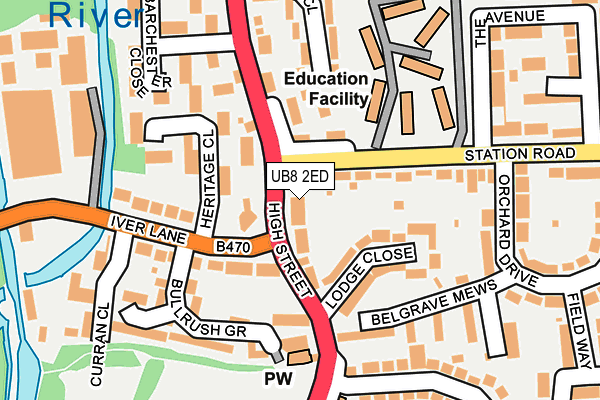
UB8 2ED lies on Edward Nelson Cottages in Cowley, Uxbridge. UB8 2ED is located in the Uxbridge electoral ward, within the London borough of Hillingdon and the English Parliamentary constituency of Uxbridge and South Ruislip. The Sub Integrated Care Board (ICB) Location is NHS North West London ICB - W2U3Z and the police force is Metropolitan Police. This postcode has been in use since January 1980.


GetTheData
Source: OS OpenMap – Local (Ordnance Survey)
Source: OS VectorMap District (Ordnance Survey)
Licence: Open Government Licence (requires attribution)
| Easting | 505423 |
| Northing | 182315 |
| Latitude | 51.529914 |
| Longitude | -0.481597 |
GetTheData
Source: Open Postcode Geo
Licence: Open Government Licence
| Street | Edward Nelson Cottages |
| Locality | Cowley |
| Town/City | Uxbridge |
| Country | England |
| Postcode District | UB8 |
| ➜ UB8 open data dashboard ➜ See where UB8 is on a map ➜ Where is London? | |
GetTheData
Source: Land Registry Price Paid Data
Licence: Open Government Licence
Elevation or altitude of UB8 2ED as distance above sea level:
| Metres | Feet | |
|---|---|---|
| Elevation | 30m | 98ft |
Elevation is measured from the approximate centre of the postcode, to the nearest point on an OS contour line from OS Terrain 50, which has contour spacing of ten vertical metres.
➜ How high above sea level am I? Find the elevation of your current position using your device's GPS.
GetTheData
Source: Open Postcode Elevation
Licence: Open Government Licence
| Ward | Uxbridge |
| Constituency | Uxbridge And South Ruislip |
GetTheData
Source: ONS Postcode Database
Licence: Open Government Licence
| July 2023 | Other theft | On or near Petrol Station | 462m |
| May 2023 | Public order | On or near Petrol Station | 462m |
| April 2023 | Vehicle crime | On or near Petrol Station | 462m |
| ➜ Get more crime data in our Crime section | |||
GetTheData
Source: data.police.uk
Licence: Open Government Licence
| Station Road Cowley | Cowley | 19m |
| Station Road Cowley | Cowley | 42m |
| Station Road Cowley (Station Road) | Cowley | 58m |
| Station Road Cowley (Station Road) | Cowley | 70m |
| Iver Lane | Cowley | 154m |
| West Drayton Station | 2.3km |
| Iver Station | 3km |
| Langley (Berks) Station | 4.8km |
GetTheData
Source: NaPTAN
Licence: Open Government Licence
| Percentage of properties with Next Generation Access | 100.0% |
| Percentage of properties with Superfast Broadband | 100.0% |
| Percentage of properties with Ultrafast Broadband | 100.0% |
| Percentage of properties with Full Fibre Broadband | 0.0% |
Superfast Broadband is between 30Mbps and 300Mbps
Ultrafast Broadband is > 300Mbps
| Percentage of properties unable to receive 2Mbps | 0.0% |
| Percentage of properties unable to receive 5Mbps | 0.0% |
| Percentage of properties unable to receive 10Mbps | 0.0% |
| Percentage of properties unable to receive 30Mbps | 0.0% |
GetTheData
Source: Ofcom
Licence: Ofcom Terms of Use (requires attribution)
GetTheData
Source: ONS Postcode Database
Licence: Open Government Licence

➜ Get more ratings from the Food Standards Agency
GetTheData
Source: Food Standards Agency
Licence: FSA terms & conditions
| Last Collection | |||
|---|---|---|---|
| Location | Mon-Fri | Sat | Distance |
| Cowley Post Office | 18:45 | 12:00 | 210m |
| Cowley Road | 18:45 | 12:30 | 288m |
| Station Road | 18:45 | 12:30 | 305m |
GetTheData
Source: Dracos
Licence: Creative Commons Attribution-ShareAlike
| Facility | Distance |
|---|---|
| Cowley Recreation Ground High Street, Uxbridge Grass Pitches | 354m |
| Cowley St Laurence C Of E Primary School Worcester Road, Uxbridge Grass Pitches | 471m |
| Brunel University Sports Centre Kingston Lane, Uxbridge Health and Fitness Gym, Sports Hall, Squash Courts, Studio | 880m |
GetTheData
Source: Active Places
Licence: Open Government Licence
| School | Phase of Education | Distance |
|---|---|---|
| Cowley St Laurence CofE Primary School Worcester Road, Cowley, Uxbridge, UB8 3TH | Primary | 445m |
| Brunel University Kingston Lane, Uxbridge, UB8 3PH | Not applicable | 690m |
| Uxbridge High School The Greenway, Uxbridge, UB8 2PR | Secondary | 995m |
GetTheData
Source: Edubase
Licence: Open Government Licence
The below table lists the International Territorial Level (ITL) codes (formerly Nomenclature of Territorial Units for Statistics (NUTS) codes) and Local Administrative Units (LAU) codes for UB8 2ED:
| ITL 1 Code | Name |
|---|---|
| TLI | London |
| ITL 2 Code | Name |
| TLI7 | Outer London - West and North West |
| ITL 3 Code | Name |
| TLI74 | Harrow and Hillingdon |
| LAU 1 Code | Name |
| E09000017 | Hillingdon |
GetTheData
Source: ONS Postcode Directory
Licence: Open Government Licence
The below table lists the Census Output Area (OA), Lower Layer Super Output Area (LSOA), and Middle Layer Super Output Area (MSOA) for UB8 2ED:
| Code | Name | |
|---|---|---|
| OA | E00012531 | |
| LSOA | E01033724 | Hillingdon 016F |
| MSOA | E02000509 | Hillingdon 016 |
GetTheData
Source: ONS Postcode Directory
Licence: Open Government Licence
| UB8 2EE | Anchor Cottages | 7m |
| UB8 2EB | High Street | 18m |
| UB8 2EF | Hope Cottages | 20m |
| UB8 2EG | High Street | 39m |
| UB8 2EH | Cycondel Villas | 60m |
| UB8 2LB | Heritage Close | 68m |
| UB8 3AA | Station Road | 71m |
| UB8 2NY | High Street | 76m |
| UB8 2LD | Heritage Close | 78m |
| UB8 2EJ | Violet Cottages | 90m |
GetTheData
Source: Open Postcode Geo; Land Registry Price Paid Data
Licence: Open Government Licence