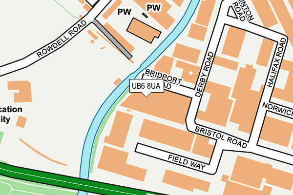
UB6 8UA is located in the Central Greenford electoral ward, within the London borough of Ealing and the English Parliamentary constituency of Ealing North. The Sub Integrated Care Board (ICB) Location is NHS North West London ICB - W2U3Z and the police force is Metropolitan Police. This postcode has been in use since January 1980.


GetTheData
Source: OS OpenMap – Local (Ordnance Survey)
Source: OS VectorMap District (Ordnance Survey)
Licence: Open Government Licence (requires attribution)
| Easting | 513563 |
| Northing | 183770 |
| Latitude | 51.541413 |
| Longitude | -0.363853 |
GetTheData
Source: Open Postcode Geo
Licence: Open Government Licence
| Country | England |
| Postcode District | UB6 |
| ➜ UB6 open data dashboard ➜ See where UB6 is on a map ➜ Where is Northolt? | |
GetTheData
Source: Land Registry Price Paid Data
Licence: Open Government Licence
Elevation or altitude of UB6 8UA as distance above sea level:
| Metres | Feet | |
|---|---|---|
| Elevation | 30m | 98ft |
Elevation is measured from the approximate centre of the postcode, to the nearest point on an OS contour line from OS Terrain 50, which has contour spacing of ten vertical metres.
➜ How high above sea level am I? Find the elevation of your current position using your device's GPS.
GetTheData
Source: Open Postcode Elevation
Licence: Open Government Licence
| Ward | Central Greenford |
| Constituency | Ealing North |
GetTheData
Source: ONS Postcode Database
Licence: Open Government Licence
| January 2024 | Anti-social behaviour | On or near Summit Road | 455m |
| December 2023 | Vehicle crime | On or near Summit Road | 455m |
| November 2023 | Anti-social behaviour | On or near Summit Road | 455m |
| ➜ Get more crime data in our Crime section | |||
GetTheData
Source: data.police.uk
Licence: Open Government Licence
| Fort Road (Rowdell Road) | Northolt | 212m |
| Belvue School (Rowdell Road) | Northolt | 234m |
| Fort Road (Rowdell Road) | Northolt | 236m |
| Belvue School (Rowdell Road) | Northolt | 265m |
| Greenford Industrial Estate (Rowdell Road) | Northolt | 374m |
| Northolt Underground Station | Northolt | 830m |
| Greenford Underground Station | Greenford | 1,240m |
| Greenford Station | 1.3km |
| Northolt Park Station | 1.8km |
| South Greenford Station | 2.1km |
GetTheData
Source: NaPTAN
Licence: Open Government Licence
GetTheData
Source: ONS Postcode Database
Licence: Open Government Licence


➜ Get more ratings from the Food Standards Agency
GetTheData
Source: Food Standards Agency
Licence: FSA terms & conditions
| Last Collection | |||
|---|---|---|---|
| Location | Mon-Fri | Sat | Distance |
| Keats Way | 18:15 | 12:30 | 344m |
| Long Drive | 16:15 | 12:15 | 364m |
| Millet Road | 17:15 | 11:45 | 519m |
GetTheData
Source: Dracos
Licence: Creative Commons Attribution-ShareAlike
| Facility | Distance |
|---|---|
| Puregym (Northolt) Rowdell Road, Northolt Swimming Pool, Health and Fitness Gym, Studio | 190m |
| Ealing Golf Driving Range (Closed) Rowdell Road, Northolt Golf | 247m |
| Belvue School Rowdell Road, Northolt Sports Hall | 354m |
GetTheData
Source: Active Places
Licence: Open Government Licence
| School | Phase of Education | Distance |
|---|---|---|
| Belvue School Rowdell Road, Northolt, UB5 6AG | Not applicable | 314m |
| Gifford Primary School Greenhill Gardens, Northolt, UB5 6BU | Primary | 913m |
| Ravenor Primary School Greenway Gardens, Greenford, UB6 9TT | Primary | 959m |
GetTheData
Source: Edubase
Licence: Open Government Licence
The below table lists the International Territorial Level (ITL) codes (formerly Nomenclature of Territorial Units for Statistics (NUTS) codes) and Local Administrative Units (LAU) codes for UB6 8UA:
| ITL 1 Code | Name |
|---|---|
| TLI | London |
| ITL 2 Code | Name |
| TLI7 | Outer London - West and North West |
| ITL 3 Code | Name |
| TLI73 | Ealing |
| LAU 1 Code | Name |
| E09000009 | Ealing |
GetTheData
Source: ONS Postcode Directory
Licence: Open Government Licence
The below table lists the Census Output Area (OA), Lower Layer Super Output Area (LSOA), and Middle Layer Super Output Area (MSOA) for UB6 8UA:
| Code | Name | |
|---|---|---|
| OA | E00006322 | |
| LSOA | E01001265 | Ealing 006A |
| MSOA | E02000243 | Ealing 006 |
GetTheData
Source: ONS Postcode Directory
Licence: Open Government Licence
| UB5 6AG | Rowdell Road | 165m |
| UB5 5HH | Fort Road | 329m |
| UB6 8WA | Kelvin Industrial Estate | 354m |
| UB6 8NB | Long Drive | 386m |
| UB5 5HL | Summit Road | 399m |
| UB6 8NU | Jeymer Drive | 406m |
| UB6 8LR | Norseman Way | 414m |
| UB6 8UH | Long Drive | 424m |
| UB5 6UA | Old Bridge Close | 447m |
| UB6 8LP | Chartwell Close | 451m |
GetTheData
Source: Open Postcode Geo; Land Registry Price Paid Data
Licence: Open Government Licence