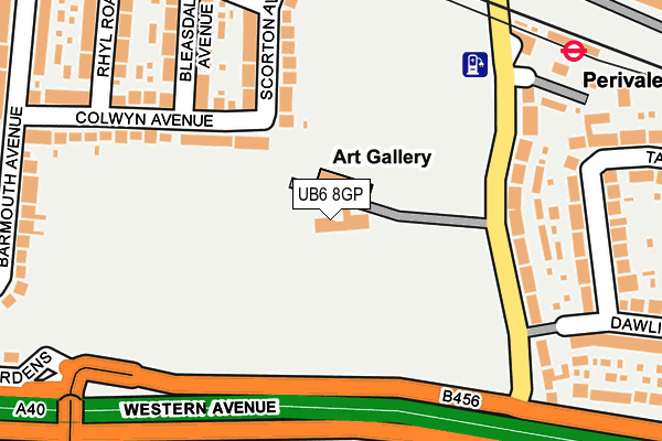
UB6 8GP is located in the Perivale electoral ward, within the London borough of Ealing and the English Parliamentary constituency of Ealing North. The Sub Integrated Care Board (ICB) Location is NHS North West London ICB - W2U3Z and the police force is Metropolitan Police. This postcode has been in use since October 2013.


GetTheData
Source: OS OpenMap – Local (Ordnance Survey)
Source: OS VectorMap District (Ordnance Survey)
Licence: Open Government Licence (requires attribution)
| Easting | 516186 |
| Northing | 183151 |
| Latitude | 51.535318 |
| Longitude | -0.326228 |
GetTheData
Source: Open Postcode Geo
Licence: Open Government Licence
| Country | England |
| Postcode District | UB6 |
| ➜ UB6 open data dashboard ➜ See where UB6 is on a map ➜ Where is Greenford? | |
GetTheData
Source: Land Registry Price Paid Data
Licence: Open Government Licence
Elevation or altitude of UB6 8GP as distance above sea level:
| Metres | Feet | |
|---|---|---|
| Elevation | 20m | 66ft |
Elevation is measured from the approximate centre of the postcode, to the nearest point on an OS contour line from OS Terrain 50, which has contour spacing of ten vertical metres.
➜ How high above sea level am I? Find the elevation of your current position using your device's GPS.
GetTheData
Source: Open Postcode Elevation
Licence: Open Government Licence
| Ward | Perivale |
| Constituency | Ealing North |
GetTheData
Source: ONS Postcode Database
Licence: Open Government Licence
| June 2022 | Anti-social behaviour | On or near Parking Area | 78m |
| June 2022 | Drugs | On or near Scorton Avenue | 167m |
| June 2022 | Bicycle theft | On or near Colwyn Avenue | 205m |
| ➜ Get more crime data in our Crime section | |||
GetTheData
Source: data.police.uk
Licence: Open Government Licence
| Dawlish Avenue (Horsenden Lane South) | Perivale | 127m |
| Dawlish Avenue (Horsenden Lane South) | Perivale | 181m |
| Teignmouth Gardens | Perivale | 192m |
| Perivale (Horsenden Lane South) | Perivale | 197m |
| Teignmouth Gardens | Perivale | 201m |
| Perivale Underground Station | Perivale | 249m |
| Greenford Underground Station | Greenford | 1,585m |
| South Greenford Station | 0.7km |
| Castle Bar Park Station | 1.4km |
| Greenford Station | 1.6km |
GetTheData
Source: NaPTAN
Licence: Open Government Licence
GetTheData
Source: ONS Postcode Database
Licence: Open Government Licence


➜ Get more ratings from the Food Standards Agency
GetTheData
Source: Food Standards Agency
Licence: FSA terms & conditions
| Last Collection | |||
|---|---|---|---|
| Location | Mon-Fri | Sat | Distance |
| Outside Perivale Station | 18:00 | 11:45 | 207m |
| Central Parade | 16:45 | 12:15 | 280m |
| Teignmouth Gardens | 16:30 | 12:00 | 344m |
GetTheData
Source: Dracos
Licence: Creative Commons Attribution-ShareAlike
| Facility | Distance |
|---|---|
| Ealing Central Sports Ground Horsenden Lane South, Perivale, Greenford Grass Pitches | 15m |
| Hanwell Town Football Club Perivale Lane, Perivale, Greenford Grass Pitches | 300m |
| St Benedicts School (Perivale Playing Field) Perivale Lane, Perivale Grass Pitches, Artificial Grass Pitch, Outdoor Tennis Courts | 476m |
GetTheData
Source: Active Places
Licence: Open Government Licence
| School | Phase of Education | Distance |
|---|---|---|
| Selborne Primary School Conway Crescent, Perivale, Greenford, UB6 8JD | Primary | 630m |
| St John Fisher Catholic Primary School Sarsfield Road, Perivale, Greenford, UB6 7AF | Primary | 1km |
| Perivale Primary School Federal Road, Perivale, Greenford, UB6 7AP | Primary | 1.1km |
GetTheData
Source: Edubase
Licence: Open Government Licence
The below table lists the International Territorial Level (ITL) codes (formerly Nomenclature of Territorial Units for Statistics (NUTS) codes) and Local Administrative Units (LAU) codes for UB6 8GP:
| ITL 1 Code | Name |
|---|---|
| TLI | London |
| ITL 2 Code | Name |
| TLI7 | Outer London - West and North West |
| ITL 3 Code | Name |
| TLI73 | Ealing |
| LAU 1 Code | Name |
| E09000009 | Ealing |
GetTheData
Source: ONS Postcode Directory
Licence: Open Government Licence
The below table lists the Census Output Area (OA), Lower Layer Super Output Area (LSOA), and Middle Layer Super Output Area (MSOA) for UB6 8GP:
| Code | Name | |
|---|---|---|
| OA | E00006711 | |
| LSOA | E01001348 | Ealing 007D |
| MSOA | E02000244 | Ealing 007 |
GetTheData
Source: ONS Postcode Directory
Licence: Open Government Licence
| UB6 8JZ | Colwyn Avenue | 131m |
| UB6 8LA | Scorton Avenue | 156m |
| UB6 8AD | Horsenden Lane South | 157m |
| UB6 8AE | Horsenden Lane South | 198m |
| UB6 8LB | Bleasdale Avenue | 200m |
| UB6 8JY | Colwyn Avenue | 205m |
| UB6 8AW | Tavistock Avenue | 214m |
| UB6 8AB | Horsenden Lane South | 236m |
| UB6 8AJ | Tavistock Avenue | 243m |
| UB6 8AR | Chilham Close | 248m |
GetTheData
Source: Open Postcode Geo; Land Registry Price Paid Data
Licence: Open Government Licence