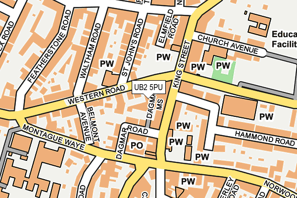
UB2 5PU is located in the Southall Green electoral ward, within the London borough of Ealing and the English Parliamentary constituency of Ealing, Southall. The Sub Integrated Care Board (ICB) Location is NHS North West London ICB - W2U3Z and the police force is Metropolitan Police. This postcode has been in use since January 1980.


GetTheData
Source: OS OpenMap – Local (Ordnance Survey)
Source: OS VectorMap District (Ordnance Survey)
Licence: Open Government Licence (requires attribution)
| Easting | 512293 |
| Northing | 179201 |
| Latitude | 51.500602 |
| Longitude | -0.383612 |
GetTheData
Source: Open Postcode Geo
Licence: Open Government Licence
| Country | England |
| Postcode District | UB2 |
| ➜ UB2 open data dashboard ➜ See where UB2 is on a map ➜ Where is Southall? | |
GetTheData
Source: Land Registry Price Paid Data
Licence: Open Government Licence
Elevation or altitude of UB2 5PU as distance above sea level:
| Metres | Feet | |
|---|---|---|
| Elevation | 30m | 98ft |
Elevation is measured from the approximate centre of the postcode, to the nearest point on an OS contour line from OS Terrain 50, which has contour spacing of ten vertical metres.
➜ How high above sea level am I? Find the elevation of your current position using your device's GPS.
GetTheData
Source: Open Postcode Elevation
Licence: Open Government Licence
| Ward | Southall Green |
| Constituency | Ealing, Southall |
GetTheData
Source: ONS Postcode Database
Licence: Open Government Licence
| January 2024 | Other theft | On or near Parking Area | 111m |
| January 2024 | Vehicle crime | On or near Parking Area | 167m |
| January 2024 | Anti-social behaviour | On or near Featherstone Road | 218m |
| ➜ Get more crime data in our Crime section | |||
GetTheData
Source: data.police.uk
Licence: Open Government Licence
| King Street (Ub2) (King Street) | Southall | 49m |
| Waltham Road (Western Road) | Southall | 88m |
| Havelock Rd Norwood Green (Havelock Road) | Norwood Green | 114m |
| King Street (Ub2) (King Street) | Southall | 135m |
| Adelaide Road (Norwood Road) | Norwood Green | 156m |
| Southall Station | 0.7km |
| Hayes & Harlington Station | 2.6km |
| Hanwell Station | 3.4km |
GetTheData
Source: NaPTAN
Licence: Open Government Licence
GetTheData
Source: ONS Postcode Database
Licence: Open Government Licence


➜ Get more ratings from the Food Standards Agency
GetTheData
Source: Food Standards Agency
Licence: FSA terms & conditions
| Last Collection | |||
|---|---|---|---|
| Location | Mon-Fri | Sat | Distance |
| King Street Post Office | 19:00 | 12:30 | 154m |
| St John's Road | 17:15 | 12:00 | 176m |
| Western Road | 17:30 | 12:00 | 245m |
GetTheData
Source: Dracos
Licence: Creative Commons Attribution-ShareAlike
| Facility | Distance |
|---|---|
| Clifton Primary School Clifton Road, Southall Sports Hall | 283m |
| Featherstone Sports Centre (Southall) Montague Waye, Southall Sports Hall, Health and Fitness Gym, Artificial Grass Pitch, Studio, Outdoor Tennis Courts | 376m |
| The Gym Group (London Southall) The Green, Southall Health and Fitness Gym | 492m |
GetTheData
Source: Active Places
Licence: Open Government Licence
| School | Phase of Education | Distance |
|---|---|---|
| Featherstone High School 11 Montague Waye, Southall, UB2 5HF | Secondary | 275m |
| St Anselm's Catholic Primary School Church Avenue, Southall, UB2 4DH | Primary | 275m |
| Clifton Primary School Clifton Road, Southall, UB2 5QP | Primary | 284m |
GetTheData
Source: Edubase
Licence: Open Government Licence
The below table lists the International Territorial Level (ITL) codes (formerly Nomenclature of Territorial Units for Statistics (NUTS) codes) and Local Administrative Units (LAU) codes for UB2 5PU:
| ITL 1 Code | Name |
|---|---|
| TLI | London |
| ITL 2 Code | Name |
| TLI7 | Outer London - West and North West |
| ITL 3 Code | Name |
| TLI73 | Ealing |
| LAU 1 Code | Name |
| E09000009 | Ealing |
GetTheData
Source: ONS Postcode Directory
Licence: Open Government Licence
The below table lists the Census Output Area (OA), Lower Layer Super Output Area (LSOA), and Middle Layer Super Output Area (MSOA) for UB2 5PU:
| Code | Name | |
|---|---|---|
| OA | E00006816 | |
| LSOA | E01001367 | Ealing 037B |
| MSOA | E02000274 | Ealing 037 |
GetTheData
Source: ONS Postcode Directory
Licence: Open Government Licence
| UB2 4DB | King Street | 34m |
| UB2 5HA | Western Road | 37m |
| UB2 4DQ | King Street | 61m |
| UB2 5HD | Western Road | 83m |
| UB2 5NX | Dagmar Road | 83m |
| UB2 4DD | King Street | 94m |
| UB2 4DG | King Street | 117m |
| UB2 5AN | St Johns Road | 119m |
| UB2 4EG | Hammond Road | 120m |
| UB2 5HT | Belmont Avenue | 123m |
GetTheData
Source: Open Postcode Geo; Land Registry Price Paid Data
Licence: Open Government Licence