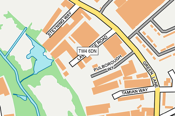
TW4 6DN is located in the Cranford electoral ward, within the London borough of Hounslow and the English Parliamentary constituency of Feltham and Heston. The Sub Integrated Care Board (ICB) Location is NHS North West London ICB - W2U3Z and the police force is Metropolitan Police. This postcode has been in use since January 1980.


GetTheData
Source: OS OpenMap – Local (Ordnance Survey)
Source: OS VectorMap District (Ordnance Survey)
Licence: Open Government Licence (requires attribution)
| Easting | 511272 |
| Northing | 175190 |
| Latitude | 51.464753 |
| Longitude | -0.399578 |
GetTheData
Source: Open Postcode Geo
Licence: Open Government Licence
| Country | England |
| Postcode District | TW4 |
➜ See where TW4 is on a map ➜ Where is London? | |
GetTheData
Source: Land Registry Price Paid Data
Licence: Open Government Licence
Elevation or altitude of TW4 6DN as distance above sea level:
| Metres | Feet | |
|---|---|---|
| Elevation | 20m | 66ft |
Elevation is measured from the approximate centre of the postcode, to the nearest point on an OS contour line from OS Terrain 50, which has contour spacing of ten vertical metres.
➜ How high above sea level am I? Find the elevation of your current position using your device's GPS.
GetTheData
Source: Open Postcode Elevation
Licence: Open Government Licence
| Ward | Cranford |
| Constituency | Feltham And Heston |
GetTheData
Source: ONS Postcode Database
Licence: Open Government Licence
| Lichfield Road (Tw4) | Hounslow West | 317m |
| Lichfield Road (Tw4) | Hounslow West | 373m |
| Basildene Road | Hounslow West | 460m |
| Beavers Community School | Hounslow West | 471m |
| Basildene Road | Hounslow West | 473m |
| Hounslow West Underground Station | Hounslow West | 1,326m |
| Feltham Station | 2km |
| Hounslow Station | 2.6km |
| Heathrow Terminal 4 Station | 3.3km |
GetTheData
Source: NaPTAN
Licence: Open Government Licence
GetTheData
Source: ONS Postcode Database
Licence: Open Government Licence


➜ Get more ratings from the Food Standards Agency
GetTheData
Source: Food Standards Agency
Licence: FSA terms & conditions
| Last Collection | |||
|---|---|---|---|
| Location | Mon-Fri | Sat | Distance |
| Green Lane | 18:30 | 11:15 | 264m |
| Post Office | 17:00 | 11:15 | 543m |
| Chester Road | 17:30 | 12:00 | 543m |
GetTheData
Source: Dracos
Licence: Creative Commons Attribution-ShareAlike
The below table lists the International Territorial Level (ITL) codes (formerly Nomenclature of Territorial Units for Statistics (NUTS) codes) and Local Administrative Units (LAU) codes for TW4 6DN:
| ITL 1 Code | Name |
|---|---|
| TLI | London |
| ITL 2 Code | Name |
| TLI7 | Outer London - West and North West |
| ITL 3 Code | Name |
| TLI75 | Hounslow and Richmond upon Thames |
| LAU 1 Code | Name |
| E09000018 | Hounslow |
GetTheData
Source: ONS Postcode Directory
Licence: Open Government Licence
The below table lists the Census Output Area (OA), Lower Layer Super Output Area (LSOA), and Middle Layer Super Output Area (MSOA) for TW4 6DN:
| Code | Name | |
|---|---|---|
| OA | E00012869 | |
| LSOA | E01002589 | Hounslow 013E |
| MSOA | E02000538 | Hounslow 013 |
GetTheData
Source: ONS Postcode Directory
Licence: Open Government Licence
| TW4 6DR | Maple Grove Business Centre | 94m |
| TW4 6DL | Steyning Way | 145m |
| TW4 6BH | Amberley Way | 238m |
| TW4 6BX | Freehold Industrial Centre | 282m |
| TW4 6EB | Green Lane | 283m |
| TW4 6ED | Green Lane | 283m |
| TW4 6EE | Green Lane | 304m |
| TW4 6HT | Lichfield Road | 431m |
| TW4 6HS | Lichfield Road | 448m |
| TW4 6JF | Green Lane | 467m |
GetTheData
Source: Open Postcode Geo; Land Registry Price Paid Data
Licence: Open Government Licence