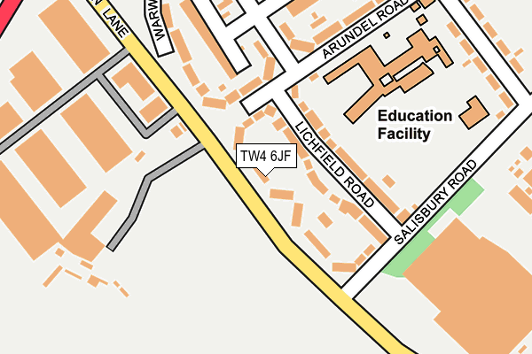
TW4 6JF lies on Green Lane in Hounslow. TW4 6JF is located in the Cranford electoral ward, within the London borough of Hounslow and the English Parliamentary constituency of Feltham and Heston. The Sub Integrated Care Board (ICB) Location is NHS North West London ICB - W2U3Z and the police force is Metropolitan Police. This postcode has been in use since January 1980.


GetTheData
Source: OS OpenMap – Local (Ordnance Survey)
Source: OS VectorMap District (Ordnance Survey)
Licence: Open Government Licence (requires attribution)
| Easting | 511052 |
| Northing | 175602 |
| Latitude | 51.468499 |
| Longitude | -0.402614 |
GetTheData
Source: Open Postcode Geo
Licence: Open Government Licence
| Street | Green Lane |
| Town/City | Hounslow |
| Country | England |
| Postcode District | TW4 |
➜ See where TW4 is on a map ➜ Where is London? | |
GetTheData
Source: Land Registry Price Paid Data
Licence: Open Government Licence
Elevation or altitude of TW4 6JF as distance above sea level:
| Metres | Feet | |
|---|---|---|
| Elevation | 20m | 66ft |
Elevation is measured from the approximate centre of the postcode, to the nearest point on an OS contour line from OS Terrain 50, which has contour spacing of ten vertical metres.
➜ How high above sea level am I? Find the elevation of your current position using your device's GPS.
GetTheData
Source: Open Postcode Elevation
Licence: Open Government Licence
| Ward | Cranford |
| Constituency | Feltham And Heston |
GetTheData
Source: ONS Postcode Database
Licence: Open Government Licence
| Green Lane (Tw4) (Green Lane) | Hounslow West | 43m |
| Green Lane (Tw4) (Green Lane) | Hounslow West | 86m |
| Lichfield Road (Tw4) | Hounslow West | 161m |
| Lichfield Road (Tw4) | Hounslow West | 175m |
| Beavers Community School | Hounslow West | 281m |
| Hounslow West Underground Station | Hounslow West | 1,246m |
| Hatton Cross Underground Station | Hatton Cross | 1,443m |
| Feltham Station | 2.3km |
| Hounslow Station | 2.9km |
| Heathrow Terminal 4 Station | 3.2km |
GetTheData
Source: NaPTAN
Licence: Open Government Licence
| Percentage of properties with Next Generation Access | 100.0% |
| Percentage of properties with Superfast Broadband | 100.0% |
| Percentage of properties with Ultrafast Broadband | 100.0% |
| Percentage of properties with Full Fibre Broadband | 0.0% |
Superfast Broadband is between 30Mbps and 300Mbps
Ultrafast Broadband is > 300Mbps
| Median download speed | 100.0Mbps |
| Average download speed | 93.8Mbps |
| Maximum download speed | 350.00Mbps |
| Median upload speed | 0.8Mbps |
| Average upload speed | 0.8Mbps |
| Maximum upload speed | 0.96Mbps |
| Percentage of properties unable to receive 2Mbps | 0.0% |
| Percentage of properties unable to receive 5Mbps | 0.0% |
| Percentage of properties unable to receive 10Mbps | 0.0% |
| Percentage of properties unable to receive 30Mbps | 0.0% |
GetTheData
Source: Ofcom
Licence: Ofcom Terms of Use (requires attribution)
Estimated total energy consumption in TW4 6JF by fuel type, 2015.
| Consumption (kWh) | 477,542 |
|---|---|
| Meter count | 34 |
| Mean (kWh/meter) | 14,045 |
| Median (kWh/meter) | 12,278 |
| Consumption (kWh) | 119,191 |
|---|---|
| Meter count | 32 |
| Mean (kWh/meter) | 3,725 |
| Median (kWh/meter) | 3,447 |
GetTheData
Source: Postcode level gas estimates: 2015 (experimental)
Source: Postcode level electricity estimates: 2015 (experimental)
Licence: Open Government Licence
GetTheData
Source: ONS Postcode Database
Licence: Open Government Licence


➜ Get more ratings from the Food Standards Agency
GetTheData
Source: Food Standards Agency
Licence: FSA terms & conditions
| Last Collection | |||
|---|---|---|---|
| Location | Mon-Fri | Sat | Distance |
| Chester Road | 17:30 | 12:00 | 115m |
| Post Office | 17:00 | 11:15 | 406m |
| Basidene Road | 17:45 | 11:45 | 618m |
GetTheData
Source: Dracos
Licence: Creative Commons Attribution-ShareAlike
The below table lists the International Territorial Level (ITL) codes (formerly Nomenclature of Territorial Units for Statistics (NUTS) codes) and Local Administrative Units (LAU) codes for TW4 6JF:
| ITL 1 Code | Name |
|---|---|
| TLI | London |
| ITL 2 Code | Name |
| TLI7 | Outer London - West and North West |
| ITL 3 Code | Name |
| TLI75 | Hounslow and Richmond upon Thames |
| LAU 1 Code | Name |
| E09000018 | Hounslow |
GetTheData
Source: ONS Postcode Directory
Licence: Open Government Licence
The below table lists the Census Output Area (OA), Lower Layer Super Output Area (LSOA), and Middle Layer Super Output Area (MSOA) for TW4 6JF:
| Code | Name | |
|---|---|---|
| OA | E00012876 | |
| LSOA | E01002589 | Hounslow 013E |
| MSOA | E02000538 | Hounslow 013 |
GetTheData
Source: ONS Postcode Directory
Licence: Open Government Licence
| TW4 6HT | Lichfield Road | 62m |
| TW4 6HS | Lichfield Road | 96m |
| TW4 6HU | Arundel Road | 104m |
| TW4 6FB | Chester Road | 164m |
| TW4 6HX | Chester Road | 180m |
| TW4 6HR | Arundel Road | 202m |
| TW4 6HP | Chester Road | 216m |
| TW4 6HY | Warwick Road | 218m |
| TW4 6DT | Fusiliers Way | 265m |
| TW4 6HQ | Beavers Lane | 272m |
GetTheData
Source: Open Postcode Geo; Land Registry Price Paid Data
Licence: Open Government Licence