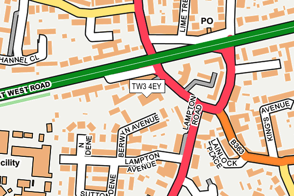
TW3 4EY lies on Lampton Road in Hounslow. TW3 4EY is located in the Heston East electoral ward, within the London borough of Hounslow and the English Parliamentary constituency of Feltham and Heston. The Sub Integrated Care Board (ICB) Location is NHS North West London ICB - W2U3Z and the police force is Metropolitan Police. This postcode has been in use since December 1997.


GetTheData
Source: OS OpenMap – Local (Ordnance Survey)
Source: OS VectorMap District (Ordnance Survey)
Licence: Open Government Licence (requires attribution)
| Easting | 513659 |
| Northing | 176746 |
| Latitude | 51.478264 |
| Longitude | -0.364731 |
GetTheData
Source: Open Postcode Geo
Licence: Open Government Licence
| Street | Lampton Road |
| Town/City | Hounslow |
| Country | England |
| Postcode District | TW3 |
| ➜ TW3 open data dashboard ➜ See where TW3 is on a map ➜ Where is London? | |
GetTheData
Source: Land Registry Price Paid Data
Licence: Open Government Licence
Elevation or altitude of TW3 4EY as distance above sea level:
| Metres | Feet | |
|---|---|---|
| Elevation | 30m | 98ft |
Elevation is measured from the approximate centre of the postcode, to the nearest point on an OS contour line from OS Terrain 50, which has contour spacing of ten vertical metres.
➜ How high above sea level am I? Find the elevation of your current position using your device's GPS.
GetTheData
Source: Open Postcode Elevation
Licence: Open Government Licence
| Ward | Heston East |
| Constituency | Feltham And Heston |
GetTheData
Source: ONS Postcode Database
Licence: Open Government Licence
| June 2022 | Anti-social behaviour | On or near Great West Road | 60m |
| June 2022 | Anti-social behaviour | On or near Spring Grove Road | 121m |
| June 2022 | Vehicle crime | On or near Spring Grove Road | 121m |
| ➜ Get more crime data in our Crime section | |||
GetTheData
Source: data.police.uk
Licence: Open Government Licence
| Great West Road Lampton Road (Lampton Road) | Lampton | 32m |
| Lampton Road | Lampton | 117m |
| Lampton Road (Great West Road) | Lampton | 120m |
| Lampton Avenue | Lampton | 132m |
| Sutton Road (Heston Road) | Lampton | 142m |
| Hounslow Central Underground Station | Hounslow Central | 786m |
| Hounslow East Underground Station | Hounslow East | 803m |
| Osterley Underground Station | Osterley | 931m |
| Hounslow Station | 1.8km |
| Isleworth Station | 2km |
| Syon Lane Station | 2.8km |
GetTheData
Source: NaPTAN
Licence: Open Government Licence
GetTheData
Source: ONS Postcode Database
Licence: Open Government Licence


➜ Get more ratings from the Food Standards Agency
GetTheData
Source: Food Standards Agency
Licence: FSA terms & conditions
| Last Collection | |||
|---|---|---|---|
| Location | Mon-Fri | Sat | Distance |
| Lampton Avenue | 17:15 | 11:45 | 138m |
| Post Office 504 Gt West Road | 17:30 | 12:00 | 169m |
| Heston Road | 17:45 | 12:00 | 212m |
GetTheData
Source: Dracos
Licence: Creative Commons Attribution-ShareAlike
| Facility | Distance |
|---|---|
| Lampton School Lampton Avenue, Hounslow Grass Pitches, Sports Hall | 252m |
| Lampton Sports Centre (Closed) Lampton Avenue, Hounslow Health and Fitness Gym | 289m |
| Brentford Fc (Jersey Road Training Ground) Jersey Road, Isleworth Grass Pitches | 665m |
GetTheData
Source: Active Places
Licence: Open Government Licence
| School | Phase of Education | Distance |
|---|---|---|
| Lampton Academy Lampton Avenue, Hounslow, TW3 4EP | Secondary | 252m |
| Alexandra Primary School Denbigh Road, Hounslow, TW3 4DU | Primary | 537m |
| Heston Community School Heston Road, Heston, Hounslow, TW5 0QR | Secondary | 708m |
GetTheData
Source: Edubase
Licence: Open Government Licence
The below table lists the International Territorial Level (ITL) codes (formerly Nomenclature of Territorial Units for Statistics (NUTS) codes) and Local Administrative Units (LAU) codes for TW3 4EY:
| ITL 1 Code | Name |
|---|---|
| TLI | London |
| ITL 2 Code | Name |
| TLI7 | Outer London - West and North West |
| ITL 3 Code | Name |
| TLI75 | Hounslow and Richmond upon Thames |
| LAU 1 Code | Name |
| E09000018 | Hounslow |
GetTheData
Source: ONS Postcode Directory
Licence: Open Government Licence
The below table lists the Census Output Area (OA), Lower Layer Super Output Area (LSOA), and Middle Layer Super Output Area (MSOA) for TW3 4EY:
| Code | Name | |
|---|---|---|
| OA | E00013071 | |
| LSOA | E01002629 | Hounslow 011E |
| MSOA | E02000536 | Hounslow 011 |
GetTheData
Source: ONS Postcode Directory
Licence: Open Government Licence
| TW3 4ET | Berwyn Avenue | 58m |
| TW5 0BY | Great West Road | 80m |
| TW3 4EX | Lampton Road | 81m |
| TW3 4EU | Lampton Road | 108m |
| TW3 4EW | Lampton Avenue | 128m |
| TW3 4BG | Jersey Road | 128m |
| TW3 4ER | North Dene | 141m |
| TW5 0TA | Great West Road | 142m |
| TW5 0PD | Great West Road | 144m |
| TW3 4EZ | Lampton Road | 158m |
GetTheData
Source: Open Postcode Geo; Land Registry Price Paid Data
Licence: Open Government Licence