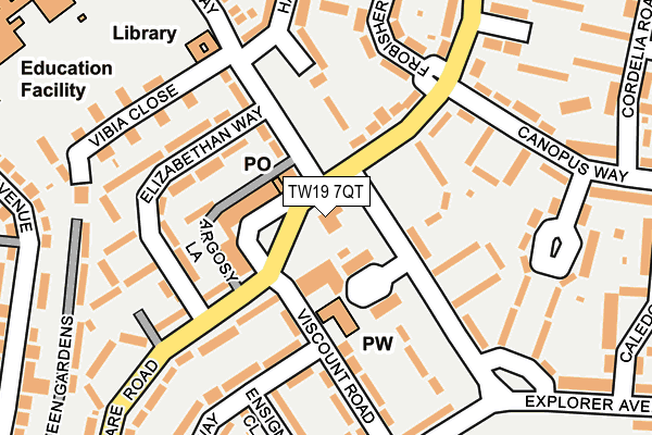
TW19 7QT lies on Clare Road in Stanwell, Staines-upon-thames. TW19 7QT is located in the Ashford North and Stanwell South electoral ward, within the local authority district of Spelthorne and the English Parliamentary constituency of Spelthorne. The Sub Integrated Care Board (ICB) Location is NHS Surrey Heartlands ICB - 92A and the police force is Surrey. This postcode has been in use since January 1980.


GetTheData
Source: OS OpenMap – Local (Ordnance Survey)
Source: OS VectorMap District (Ordnance Survey)
Licence: Open Government Licence (requires attribution)
| Easting | 506036 |
| Northing | 173570 |
| Latitude | 51.451196 |
| Longitude | -0.475409 |
GetTheData
Source: Open Postcode Geo
Licence: Open Government Licence
| Street | Clare Road |
| Locality | Stanwell |
| Town/City | Staines-upon-thames |
| Country | England |
| Postcode District | TW19 |
| ➜ TW19 open data dashboard ➜ See where TW19 is on a map ➜ Where is Stanwell? | |
GetTheData
Source: Land Registry Price Paid Data
Licence: Open Government Licence
Elevation or altitude of TW19 7QT as distance above sea level:
| Metres | Feet | |
|---|---|---|
| Elevation | 20m | 66ft |
Elevation is measured from the approximate centre of the postcode, to the nearest point on an OS contour line from OS Terrain 50, which has contour spacing of ten vertical metres.
➜ How high above sea level am I? Find the elevation of your current position using your device's GPS.
GetTheData
Source: Open Postcode Elevation
Licence: Open Government Licence
| Ward | Ashford North And Stanwell South |
| Constituency | Spelthorne |
GetTheData
Source: ONS Postcode Database
Licence: Open Government Licence
HAPPY LANDING, CLARE ROAD, STANWELL, STAINES-UPON-THAMES, TW19 7QT 2004 20 FEB £55,000 |
HAPPY LANDING, CLARE ROAD, STANWELL, STAINES-UPON-THAMES, TW19 7QT 2000 30 OCT £23,000 |
GetTheData
Source: HM Land Registry Price Paid Data
Licence: Contains HM Land Registry data © Crown copyright and database right 2024. This data is licensed under the Open Government Licence v3.0.
| January 2024 | Violence and sexual offences | On or near Clare Road | 272m |
| January 2024 | Violence and sexual offences | On or near Cambria Gardens | 328m |
| January 2024 | Violence and sexual offences | On or near Cambria Gardens | 328m |
| ➜ Get more crime data in our Crime section | |||
GetTheData
Source: data.police.uk
Licence: Open Government Licence
| Happy Landing (Clare Road) | Stanwell | 37m |
| Hadrian Way | Stanwell | 59m |
| Hadrian Close (Hadrian Way) | Stanwell | 61m |
| Hadrian Way | Stanwell | 76m |
| Happy Landing (Clare Road) | Stanwell | 124m |
| Ashford (Surrey) Station | 1.7km |
| Heathrow Terminal 4 (Rail-Air) | 2.2km |
| Heathrow Terminal 4 Station | 2.2km |
GetTheData
Source: NaPTAN
Licence: Open Government Licence
GetTheData
Source: ONS Postcode Database
Licence: Open Government Licence


➜ Get more ratings from the Food Standards Agency
GetTheData
Source: Food Standards Agency
Licence: FSA terms & conditions
| Last Collection | |||
|---|---|---|---|
| Location | Mon-Fri | Sat | Distance |
| Kingsway | 17:30 | 11:30 | 690m |
| Northumberland Close | 18:30 | 747m | |
| Cumberland Road / Dorset Road | 16:30 | 11:30 | 1,231m |
GetTheData
Source: Dracos
Licence: Creative Commons Attribution-ShareAlike
| Facility | Distance |
|---|---|
| Town Farm Primary School St. Marys Crescent, Stanwell, Staines-upon-thames Grass Pitches | 350m |
| Long Lane Recreation Ground Cambria Gardens, Staines Grass Pitches, Outdoor Tennis Courts | 395m |
| Stanwell Fields Ce Primary School Clare Road, Stanwell, Staines-upon-thames Grass Pitches | 458m |
GetTheData
Source: Active Places
Licence: Open Government Licence
| School | Phase of Education | Distance |
|---|---|---|
| Town Farm Primary School & Nursery St Mary's Crescent, Stanwell, Staines, TW19 7HU | Primary | 402m |
| Stanwell Fields CofE Primary School Clare Road, Stanwell, Staines-upon-Thames, TW19 7DB | Primary | 441m |
| Thomas Knyvett College Stanwell Road, Ashford, TW15 3DU | Secondary | 1.3km |
GetTheData
Source: Edubase
Licence: Open Government Licence
The below table lists the International Territorial Level (ITL) codes (formerly Nomenclature of Territorial Units for Statistics (NUTS) codes) and Local Administrative Units (LAU) codes for TW19 7QT:
| ITL 1 Code | Name |
|---|---|
| TLJ | South East (England) |
| ITL 2 Code | Name |
| TLJ2 | Surrey, East and West Sussex |
| ITL 3 Code | Name |
| TLJ25 | West Surrey |
| LAU 1 Code | Name |
| E07000213 | Spelthorne |
GetTheData
Source: ONS Postcode Directory
Licence: Open Government Licence
The below table lists the Census Output Area (OA), Lower Layer Super Output Area (LSOA), and Middle Layer Super Output Area (MSOA) for TW19 7QT:
| Code | Name | |
|---|---|---|
| OA | E00156611 | |
| LSOA | E01030710 | Spelthorne 002B |
| MSOA | E02006404 | Spelthorne 002 |
GetTheData
Source: ONS Postcode Directory
Licence: Open Government Licence
| TW19 7DQ | Hadrian Way | 50m |
| TW19 7QP | Clare Road | 63m |
| TW19 7HT | Hadrian Way | 68m |
| TW19 7QW | Clare Road | 91m |
| TW19 7DJ | Hadrian Way | 97m |
| TW19 7DP | Eddystone Walk | 111m |
| TW19 7QD | Argosy Lane | 118m |
| TW19 7DW | Hadrian Close | 126m |
| TW19 7HF | Hadrian Way | 128m |
| TW19 7DT | Clare Road | 131m |
GetTheData
Source: Open Postcode Geo; Land Registry Price Paid Data
Licence: Open Government Licence