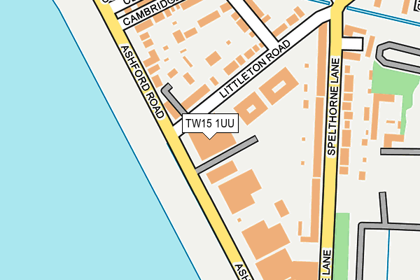
TW15 1UU lies on Littleton Road in Ashford. TW15 1UU is located in the Laleham and Shepperton Green electoral ward, within the local authority district of Spelthorne and the English Parliamentary constituency of Spelthorne. The Sub Integrated Care Board (ICB) Location is NHS Surrey Heartlands ICB - 92A and the police force is Surrey. This postcode has been in use since January 1983.


GetTheData
Source: OS OpenMap – Local (Ordnance Survey)
Source: OS VectorMap District (Ordnance Survey)
Licence: Open Government Licence (requires attribution)
| Easting | 508216 |
| Northing | 170078 |
| Latitude | 51.419397 |
| Longitude | -0.445114 |
GetTheData
Source: Open Postcode Geo
Licence: Open Government Licence
| Street | Littleton Road |
| Town/City | Ashford |
| Country | England |
| Postcode District | TW15 |
| ➜ TW15 open data dashboard ➜ See where TW15 is on a map ➜ Where is Littleton Common? | |
GetTheData
Source: Land Registry Price Paid Data
Licence: Open Government Licence
Elevation or altitude of TW15 1UU as distance above sea level:
| Metres | Feet | |
|---|---|---|
| Elevation | 20m | 66ft |
Elevation is measured from the approximate centre of the postcode, to the nearest point on an OS contour line from OS Terrain 50, which has contour spacing of ten vertical metres.
➜ How high above sea level am I? Find the elevation of your current position using your device's GPS.
GetTheData
Source: Open Postcode Elevation
Licence: Open Government Licence
| Ward | Laleham And Shepperton Green |
| Constituency | Spelthorne |
GetTheData
Source: ONS Postcode Database
Licence: Open Government Licence
| October 2023 | Anti-social behaviour | On or near Ashdene Close | 202m |
| October 2023 | Anti-social behaviour | On or near Ashdene Close | 202m |
| October 2023 | Anti-social behaviour | On or near Ashdene Close | 202m |
| ➜ Littleton Road crime map and outcomes | |||
GetTheData
Source: data.police.uk
Licence: Open Government Licence
| Thorne Close (Spelthorne Lane) | Ashford Common | 200m |
| Thorne Close (Spelthorne Lane) | Ashford Common | 206m |
| Littleton Road | Ashford Common | 336m |
| Ashford Road (Spelthorne Lane) | Charlton | 345m |
| Chertsey Road (Staines Road West) | Ashford Common | 369m |
| Upper Halliford Station | 1.2km |
| Sunbury Station | 1.9km |
| Kempton Park Station | 2.5km |
GetTheData
Source: NaPTAN
Licence: Open Government Licence
| Median download speed | 75.6Mbps |
| Average download speed | 57.4Mbps |
| Maximum download speed | 80.00Mbps |
| Median upload speed | 20.0Mbps |
| Average upload speed | 14.3Mbps |
| Maximum upload speed | 20.00Mbps |
GetTheData
Source: Ofcom
Licence: Ofcom Terms of Use (requires attribution)
GetTheData
Source: ONS Postcode Database
Licence: Open Government Licence


➜ Get more ratings from the Food Standards Agency
GetTheData
Source: Food Standards Agency
Licence: FSA terms & conditions
| Last Collection | |||
|---|---|---|---|
| Location | Mon-Fri | Sat | Distance |
| Staines Road West | 18:30 | 11:45 | 366m |
| Petrol Station | 18:30 | 11:30 | 525m |
| 215 Charlton Road | 16:45 | 12:00 | 742m |
GetTheData
Source: Dracos
Licence: Creative Commons Attribution-ShareAlike
| Facility | Distance |
|---|---|
| Spelthorne Sports Club Staines Road West, Ashford Grass Pitches | 646m |
| The Echelford Primary School Park Road, Ashford Grass Pitches, Sports Hall | 1.2km |
| Springfield Primary School Nursery Road, Sunbury-on-thames Grass Pitches | 1.5km |
GetTheData
Source: Active Places
Licence: Open Government Licence
| School | Phase of Education | Distance |
|---|---|---|
| Ashford CofE Primary School School Road, Ashford, TW15 2BW | Primary | 898m |
| Meadhurst Primary School Feltham Hill Road, Ashford, TW15 1LP | Primary | 987m |
| The Echelford Primary School Park Road, Ashford, TW15 1EX | Primary | 1.2km |
GetTheData
Source: Edubase
Licence: Open Government Licence
The below table lists the International Territorial Level (ITL) codes (formerly Nomenclature of Territorial Units for Statistics (NUTS) codes) and Local Administrative Units (LAU) codes for TW15 1UU:
| ITL 1 Code | Name |
|---|---|
| TLJ | South East (England) |
| ITL 2 Code | Name |
| TLJ2 | Surrey, East and West Sussex |
| ITL 3 Code | Name |
| TLJ25 | West Surrey |
| LAU 1 Code | Name |
| E07000213 | Spelthorne |
GetTheData
Source: ONS Postcode Directory
Licence: Open Government Licence
The below table lists the Census Output Area (OA), Lower Layer Super Output Area (LSOA), and Middle Layer Super Output Area (MSOA) for TW15 1UU:
| Code | Name | |
|---|---|---|
| OA | E00156672 | |
| LSOA | E01030725 | Spelthorne 006E |
| MSOA | E02006408 | Spelthorne 006 |
GetTheData
Source: ONS Postcode Directory
Licence: Open Government Licence
| TW15 1UY | Cornerside | 68m |
| TW15 1UQ | Littleton Road | 125m |
| TW15 1UE | Ashford Road | 151m |
| TW15 1DE | Cambridge Road | 159m |
| TW15 1UH | Spelthorne Lane | 162m |
| TW15 1UJ | Spelthorne Lane | 188m |
| TW15 1UF | Cambridge Road | 199m |
| TW15 1UN | Spelthorne Lane | 199m |
| TW15 1XB | Ashford Road | 200m |
| TW15 1UG | Ashdene Close | 205m |
GetTheData
Source: Open Postcode Geo; Land Registry Price Paid Data
Licence: Open Government Licence