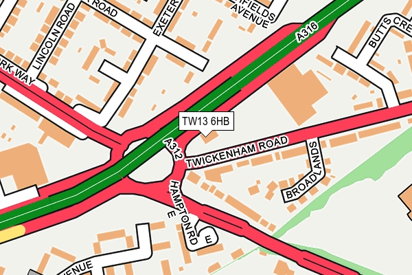
TW13 6HB is located in the West Twickenham electoral ward, within the London borough of Richmond upon Thames and the English Parliamentary constituency of Twickenham. The Sub Integrated Care Board (ICB) Location is NHS South West London ICB - 36L and the police force is Metropolitan Police. This postcode has been in use since January 1980.


GetTheData
Source: OS OpenMap – Local (Ordnance Survey)
Source: OS VectorMap District (Ordnance Survey)
Licence: Open Government Licence (requires attribution)
| Easting | 512884 |
| Northing | 172119 |
| Latitude | 51.436832 |
| Longitude | -0.377361 |
GetTheData
Source: Open Postcode Geo
Licence: Open Government Licence
| Country | England |
| Postcode District | TW13 |
| ➜ TW13 open data dashboard ➜ See where TW13 is on a map ➜ Where is London? | |
GetTheData
Source: Land Registry Price Paid Data
Licence: Open Government Licence
Elevation or altitude of TW13 6HB as distance above sea level:
| Metres | Feet | |
|---|---|---|
| Elevation | 20m | 66ft |
Elevation is measured from the approximate centre of the postcode, to the nearest point on an OS contour line from OS Terrain 50, which has contour spacing of ten vertical metres.
➜ How high above sea level am I? Find the elevation of your current position using your device's GPS.
GetTheData
Source: Open Postcode Elevation
Licence: Open Government Licence
| Ward | West Twickenham |
| Constituency | Twickenham |
GetTheData
Source: ONS Postcode Database
Licence: Open Government Licence
| June 2022 | Criminal damage and arson | On or near Hampton Road East | 140m |
| June 2022 | Other theft | On or near Hampton Road East | 140m |
| June 2022 | Violence and sexual offences | On or near Hampton Road East | 140m |
| ➜ Get more crime data in our Crime section | |||
GetTheData
Source: data.police.uk
Licence: Open Government Licence
| Twickenham Road | Hanworth | 53m |
| Twickenham Road | Hanworth | 55m |
| Hampton Road East | Hanworth | 120m |
| Hampton Road East | Hanworth | 125m |
| Apex Corner Hampton Road West (Hampton Road West) | Hanworth | 161m |
| Fulwell Station | 2km |
| Whitton Station | 2km |
| Hampton (London) Station | 2.4km |
GetTheData
Source: NaPTAN
Licence: Open Government Licence
GetTheData
Source: ONS Postcode Database
Licence: Open Government Licence


➜ Get more ratings from the Food Standards Agency
GetTheData
Source: Food Standards Agency
Licence: FSA terms & conditions
| Last Collection | |||
|---|---|---|---|
| Location | Mon-Fri | Sat | Distance |
| Hampton Road East | 17:15 | 11:30 | 126m |
| York Way | 17:00 | 11:30 | 271m |
| Winifred Road | 17:00 | 12:00 | 360m |
GetTheData
Source: Dracos
Licence: Creative Commons Attribution-ShareAlike
| Facility | Distance |
|---|---|
| David Lloyd (Hampton) Staines Road, Twickenham Sports Hall, Swimming Pool, Health and Fitness Gym, Golf, Studio, Squash Courts, Outdoor Tennis Courts | 334m |
| Crane Park Primary School Norman Avenue, Feltham Grass Pitches | 586m |
| Hampton Common Buckingham Road, Hampton Grass Pitches, Cycling | 651m |
GetTheData
Source: Active Places
Licence: Open Government Licence
| School | Phase of Education | Distance |
|---|---|---|
| Crane Park Primary School Norman Avenue, Hanworth, Feltham, TW13 5LN | Primary | 678m |
| Oriel Academy West London Hounslow Road, Hanworth, Feltham, TW13 6QQ | Primary | 893m |
| Hampton High Hanworth Road, Hampton, TW12 3HB | Secondary | 899m |
GetTheData
Source: Edubase
Licence: Open Government Licence
The below table lists the International Territorial Level (ITL) codes (formerly Nomenclature of Territorial Units for Statistics (NUTS) codes) and Local Administrative Units (LAU) codes for TW13 6HB:
| ITL 1 Code | Name |
|---|---|
| TLI | London |
| ITL 2 Code | Name |
| TLI7 | Outer London - West and North West |
| ITL 3 Code | Name |
| TLI75 | Hounslow and Richmond upon Thames |
| LAU 1 Code | Name |
| E09000027 | Richmond upon Thames |
GetTheData
Source: ONS Postcode Directory
Licence: Open Government Licence
The below table lists the Census Output Area (OA), Lower Layer Super Output Area (LSOA), and Middle Layer Super Output Area (MSOA) for TW13 6HB:
| Code | Name | |
|---|---|---|
| OA | E00019644 | |
| LSOA | E01003903 | Richmond upon Thames 015F |
| MSOA | E02000798 | Richmond upon Thames 015 |
GetTheData
Source: ONS Postcode Directory
Licence: Open Government Licence
| TW13 6JA | Hampton Road East | 113m |
| TW13 5PE | Exeter Road | 127m |
| TW13 5PD | Winchester Road | 135m |
| TW13 6HD | Twickenham Road | 145m |
| TW13 6HF | Broadlands | 150m |
| TW13 6JB | Hampton Road East | 162m |
| TW13 6BQ | York Way | 189m |
| TW13 6LD | Stourton Avenue | 190m |
| TW13 6LE | Stourton Avenue | 194m |
| TW13 5PF | Sunrise Close | 205m |
GetTheData
Source: Open Postcode Geo; Land Registry Price Paid Data
Licence: Open Government Licence