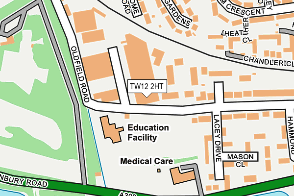
TW12 2HT is located in the Hampton electoral ward, within the London borough of Richmond upon Thames and the English Parliamentary constituency of Twickenham. The Sub Integrated Care Board (ICB) Location is NHS South West London ICB - 36L and the police force is Metropolitan Police. This postcode has been in use since January 1980.


GetTheData
Source: OS OpenMap – Local (Ordnance Survey)
Source: OS VectorMap District (Ordnance Survey)
Licence: Open Government Licence (requires attribution)
| Easting | 512775 |
| Northing | 169736 |
| Latitude | 51.415435 |
| Longitude | -0.379687 |
GetTheData
Source: Open Postcode Geo
Licence: Open Government Licence
| Country | England |
| Postcode District | TW12 |
| ➜ TW12 open data dashboard ➜ See where TW12 is on a map ➜ Where is Hampton? | |
GetTheData
Source: Land Registry Price Paid Data
Licence: Open Government Licence
Elevation or altitude of TW12 2HT as distance above sea level:
| Metres | Feet | |
|---|---|---|
| Elevation | 20m | 66ft |
Elevation is measured from the approximate centre of the postcode, to the nearest point on an OS contour line from OS Terrain 50, which has contour spacing of ten vertical metres.
➜ How high above sea level am I? Find the elevation of your current position using your device's GPS.
GetTheData
Source: Open Postcode Elevation
Licence: Open Government Licence
| Ward | Hampton |
| Constituency | Twickenham |
GetTheData
Source: ONS Postcode Database
Licence: Open Government Licence
| June 2022 | Violence and sexual offences | On or near Broome Road | 250m |
| June 2022 | Burglary | On or near Hill Field Road | 273m |
| June 2022 | Anti-social behaviour | On or near Hammond Close | 303m |
| ➜ Get more crime data in our Crime section | |||
GetTheData
Source: data.police.uk
Licence: Open Government Licence
| Hampton Care Nursing Home | Hampton | 233m |
| Hampton Care Nursing Home | Hampton | 239m |
| Stain Hill Reservoir | Hampton | 251m |
| Percy Road (Upper Sunbury Road) | Hampton | 460m |
| Oldfield Road Percy Road | Hampton | 497m |
| Hampton (London) Station | 0.5km |
| Kempton Park Station | 2.2km |
| Sunbury Station | 2.7km |
GetTheData
Source: NaPTAN
Licence: Open Government Licence
GetTheData
Source: ONS Postcode Database
Licence: Open Government Licence

➜ Get more ratings from the Food Standards Agency
GetTheData
Source: Food Standards Agency
Licence: FSA terms & conditions
| Last Collection | |||
|---|---|---|---|
| Location | Mon-Fri | Sat | Distance |
| Bloxham Crescent | 18:30 | 12:00 | 332m |
| Ashley Road | 18:30 | 12:00 | 597m |
| Hollybush Lane | 18:30 | 12:00 | 614m |
GetTheData
Source: Dracos
Licence: Creative Commons Attribution-ShareAlike
| Facility | Distance |
|---|---|
| St Mary's Hampton Ce Primary School Oldfield Road, Hampton Grass Pitches | 93m |
| Linden Hall Community Centre Linden Road, Hampton Sports Hall | 387m |
| Hampton Rangers Jfc (Denis Chaplin Training Ground) Priory Road, Hampton Grass Pitches, Artificial Grass Pitch | 396m |
GetTheData
Source: Active Places
Licence: Open Government Licence
| School | Phase of Education | Distance |
|---|---|---|
| St Mary's Hampton Church of England Primary Oldfield Road, Hampton, TW12 2HP | Primary | 262m |
| Hampton Junior School Percy Road, Hampton, TW12 2LA | Primary | 479m |
| Hampton Infant School and Nursery Ripley Road, Hampton, TW12 2JH | Primary | 483m |
GetTheData
Source: Edubase
Licence: Open Government Licence
The below table lists the International Territorial Level (ITL) codes (formerly Nomenclature of Territorial Units for Statistics (NUTS) codes) and Local Administrative Units (LAU) codes for TW12 2HT:
| ITL 1 Code | Name |
|---|---|
| TLI | London |
| ITL 2 Code | Name |
| TLI7 | Outer London - West and North West |
| ITL 3 Code | Name |
| TLI75 | Hounslow and Richmond upon Thames |
| LAU 1 Code | Name |
| E09000027 | Richmond upon Thames |
GetTheData
Source: ONS Postcode Directory
Licence: Open Government Licence
The below table lists the Census Output Area (OA), Lower Layer Super Output Area (LSOA), and Middle Layer Super Output Area (MSOA) for TW12 2HT:
| Code | Name | |
|---|---|---|
| OA | E00019209 | |
| LSOA | E01003826 | Richmond upon Thames 023E |
| MSOA | E02000806 | Richmond upon Thames 023 |
GetTheData
Source: ONS Postcode Directory
Licence: Open Government Licence
| TW12 2HD | Kingsway Business Park | 56m |
| TW12 2AF | Kempton Gate Business Centre | 130m |
| TW12 2LF | Sandringham Mews | 159m |
| TW12 2PZ | Priory Gardens | 206m |
| TW12 2HR | Oldfield Road | 207m |
| TW12 2JE | Heather Close | 212m |
| TW12 2PU | Broome Road | 232m |
| TW12 2QA | Priory Close | 242m |
| TW12 2QG | Bloxham Crescent | 246m |
| TW12 2JF | Chandler Close | 257m |
GetTheData
Source: Open Postcode Geo; Land Registry Price Paid Data
Licence: Open Government Licence