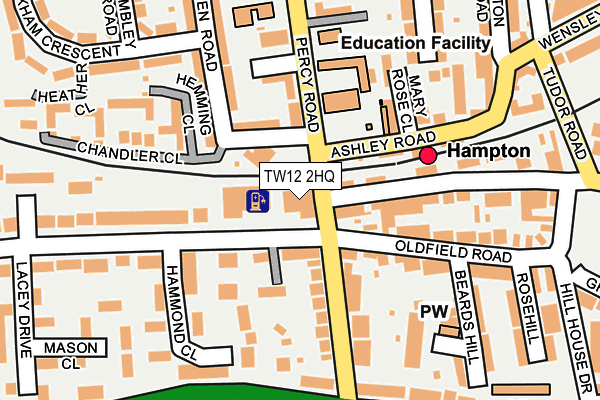
TW12 2HQ is located in the Hampton electoral ward, within the London borough of Richmond upon Thames and the English Parliamentary constituency of Twickenham. The Sub Integrated Care Board (ICB) Location is NHS South West London ICB - 36L and the police force is Metropolitan Police. This postcode has been in use since February 1990.


GetTheData
Source: OS OpenMap – Local (Ordnance Survey)
Source: OS VectorMap District (Ordnance Survey)
Licence: Open Government Licence (requires attribution)
| Easting | 513195 |
| Northing | 169764 |
| Latitude | 51.415603 |
| Longitude | -0.373641 |
GetTheData
Source: Open Postcode Geo
Licence: Open Government Licence
| Country | England |
| Postcode District | TW12 |
| ➜ TW12 open data dashboard ➜ See where TW12 is on a map ➜ Where is Hampton? | |
GetTheData
Source: Land Registry Price Paid Data
Licence: Open Government Licence
Elevation or altitude of TW12 2HQ as distance above sea level:
| Metres | Feet | |
|---|---|---|
| Elevation | 20m | 66ft |
Elevation is measured from the approximate centre of the postcode, to the nearest point on an OS contour line from OS Terrain 50, which has contour spacing of ten vertical metres.
➜ How high above sea level am I? Find the elevation of your current position using your device's GPS.
GetTheData
Source: Open Postcode Elevation
Licence: Open Government Licence
| Ward | Hampton |
| Constituency | Twickenham |
GetTheData
Source: ONS Postcode Database
Licence: Open Government Licence
| November 2023 | Bicycle theft | On or near Hill House Drive | 295m |
| September 2023 | Anti-social behaviour | On or near Hill House Drive | 295m |
| August 2023 | Violence and sexual offences | On or near Hill House Drive | 295m |
| ➜ Get more crime data in our Crime section | |||
GetTheData
Source: data.police.uk
Licence: Open Government Licence
| Hampton (Ashley Road) | Hampton | 101m |
| Hampton | Hampton | 115m |
| Hampton | Hampton | 134m |
| Hampton | Hampton | 168m |
| Percy Road (Upper Sunbury Road) | Hampton | 190m |
| Hampton (London) Station | 0.1km |
| Kempton Park Station | 2.6km |
| Hampton Court Station | 2.6km |
GetTheData
Source: NaPTAN
Licence: Open Government Licence
GetTheData
Source: ONS Postcode Database
Licence: Open Government Licence


➜ Get more ratings from the Food Standards Agency
GetTheData
Source: Food Standards Agency
Licence: FSA terms & conditions
| Last Collection | |||
|---|---|---|---|
| Location | Mon-Fri | Sat | Distance |
| Ashley Road | 18:30 | 12:00 | 184m |
| Delivery Office, Rosehill | 18:30 | 12:00 | 264m |
| Post Office, 33 Priory Road | 18:30 | 12:00 | 382m |
GetTheData
Source: Dracos
Licence: Creative Commons Attribution-ShareAlike
| Facility | Distance |
|---|---|
| Linden Hall Community Centre Linden Road, Hampton Sports Hall | 57m |
| St Mary's Hampton Ce Primary School Oldfield Road, Hampton Grass Pitches | 423m |
| Curves (Hampton Teddington) Station Road, Hampton Health and Fitness Gym | 553m |
GetTheData
Source: Active Places
Licence: Open Government Licence
| School | Phase of Education | Distance |
|---|---|---|
| Hampton Junior School Percy Road, Hampton, TW12 2LA | Primary | 111m |
| St Mary's Hampton Church of England Primary Oldfield Road, Hampton, TW12 2HP | Primary | 172m |
| Hampton Infant School and Nursery Ripley Road, Hampton, TW12 2JH | Primary | 427m |
GetTheData
Source: Edubase
Licence: Open Government Licence
The below table lists the International Territorial Level (ITL) codes (formerly Nomenclature of Territorial Units for Statistics (NUTS) codes) and Local Administrative Units (LAU) codes for TW12 2HQ:
| ITL 1 Code | Name |
|---|---|
| TLI | London |
| ITL 2 Code | Name |
| TLI7 | Outer London - West and North West |
| ITL 3 Code | Name |
| TLI75 | Hounslow and Richmond upon Thames |
| LAU 1 Code | Name |
| E09000027 | Richmond upon Thames |
GetTheData
Source: ONS Postcode Directory
Licence: Open Government Licence
The below table lists the Census Output Area (OA), Lower Layer Super Output Area (LSOA), and Middle Layer Super Output Area (MSOA) for TW12 2HQ:
| Code | Name | |
|---|---|---|
| OA | E00019232 | |
| LSOA | E01003826 | Richmond upon Thames 023E |
| MSOA | E02000806 | Richmond upon Thames 023 |
GetTheData
Source: ONS Postcode Directory
Licence: Open Government Licence
| TW12 2BL | Station Road | 51m |
| TW12 2HS | Oldfield Road | 98m |
| TW12 2LD | Percy Road | 107m |
| TW12 2HW | Percy Road | 114m |
| TW12 2AJ | Oldfield Road | 121m |
| TW12 2LB | Newfield Close | 124m |
| TW12 2HU | Ashley Road | 136m |
| TW12 2JG | Linden Road | 142m |
| TW12 2AL | Station Road | 150m |
| TW12 2AE | Oldfield Road | 152m |
GetTheData
Source: Open Postcode Geo; Land Registry Price Paid Data
Licence: Open Government Licence