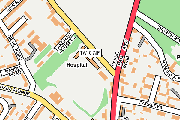
TW10 7JF is located in the Ham, Petersham & Richmond Riverside electoral ward, within the London borough of Richmond upon Thames and the English Parliamentary constituency of Richmond Park. The Sub Integrated Care Board (ICB) Location is NHS South West London ICB - 36L and the police force is Metropolitan Police. This postcode has been in use since January 1980.


GetTheData
Source: OS OpenMap – Local (Ordnance Survey)
Source: OS VectorMap District (Ordnance Survey)
Licence: Open Government Licence (requires attribution)
| Easting | 517708 |
| Northing | 171792 |
| Latitude | 51.432912 |
| Longitude | -0.308100 |
GetTheData
Source: Open Postcode Geo
Licence: Open Government Licence
| Country | England |
| Postcode District | TW10 |
| ➜ TW10 open data dashboard ➜ See where TW10 is on a map ➜ Where is London? | |
GetTheData
Source: Land Registry Price Paid Data
Licence: Open Government Licence
Elevation or altitude of TW10 7JF as distance above sea level:
| Metres | Feet | |
|---|---|---|
| Elevation | 10m | 33ft |
Elevation is measured from the approximate centre of the postcode, to the nearest point on an OS contour line from OS Terrain 50, which has contour spacing of ten vertical metres.
➜ How high above sea level am I? Find the elevation of your current position using your device's GPS.
GetTheData
Source: Open Postcode Elevation
Licence: Open Government Licence
| Ward | Ham, Petersham & Richmond Riverside |
| Constituency | Richmond Park |
GetTheData
Source: ONS Postcode Database
Licence: Open Government Licence
| November 2023 | Burglary | On or near New Road | 310m |
| September 2023 | Violence and sexual offences | On or near New Road | 310m |
| July 2023 | Public order | On or near New Road | 310m |
| ➜ Get more crime data in our Crime section | |||
GetTheData
Source: data.police.uk
Licence: Open Government Licence
| Ham Common (Upper Ham Road) | Ham | 98m |
| Ham Parade (Upper Ham Road) | Ham | 196m |
| Dysart Avenue | Ham | 237m |
| Dukes Avenue Northweald Lane | Ham | 253m |
| Ham Parade | Ham | 256m |
| Teddington Station | 2km |
| Hampton Wick Station | 2.1km |
| Strawberry Hill Station | 2.3km |
GetTheData
Source: NaPTAN
Licence: Open Government Licence
GetTheData
Source: ONS Postcode Database
Licence: Open Government Licence


➜ Get more ratings from the Food Standards Agency
GetTheData
Source: Food Standards Agency
Licence: FSA terms & conditions
| Last Collection | |||
|---|---|---|---|
| Location | Mon-Fri | Sat | Distance |
| Hand & Flower, Ham Street | 17:30 | 11:15 | 37m |
| Dukes Avenue Post Office | 17:30 | 12:00 | 285m |
| Barnfield Gardens | 17:45 | 12:15 | 364m |
GetTheData
Source: Dracos
Licence: Creative Commons Attribution-ShareAlike
| Facility | Distance |
|---|---|
| Meadlands Primary School Broughton Avenue, Richmond Grass Pitches | 544m |
| Grey Court School Ham Street, Richmond Sports Hall, Grass Pitches, Outdoor Tennis Courts | 632m |
| Ymca (Hawker) Lower Ham Road, Kingston Upon Thames Health and Fitness Gym, Grass Pitches, Studio, Outdoor Tennis Courts | 671m |
GetTheData
Source: Active Places
Licence: Open Government Licence
| School | Phase of Education | Distance |
|---|---|---|
| Malden Oaks School and Tuition Service The Dukes Centre, Dukes Avenue, Kingston upon Thames, KT2 5QY | Not applicable | 166m |
| Meadlands Primary School Broughton Avenue, Ham, Richmond, TW10 7TS | Primary | 545m |
| Grey Court School Ham Street, Ham, Richmond, TW10 7HN | Secondary | 726m |
GetTheData
Source: Edubase
Licence: Open Government Licence
The below table lists the International Territorial Level (ITL) codes (formerly Nomenclature of Territorial Units for Statistics (NUTS) codes) and Local Administrative Units (LAU) codes for TW10 7JF:
| ITL 1 Code | Name |
|---|---|
| TLI | London |
| ITL 2 Code | Name |
| TLI7 | Outer London - West and North West |
| ITL 3 Code | Name |
| TLI75 | Hounslow and Richmond upon Thames |
| LAU 1 Code | Name |
| E09000027 | Richmond upon Thames |
GetTheData
Source: ONS Postcode Directory
Licence: Open Government Licence
The below table lists the Census Output Area (OA), Lower Layer Super Output Area (LSOA), and Middle Layer Super Output Area (MSOA) for TW10 7JF:
| Code | Name | |
|---|---|---|
| OA | E00019186 | |
| LSOA | E01003817 | Richmond upon Thames 012D |
| MSOA | E02000795 | Richmond upon Thames 012 |
GetTheData
Source: ONS Postcode Directory
Licence: Open Government Licence
| TW10 7JU | Ham Common | 68m |
| TW10 5LA | Upper Ham Road | 113m |
| TW10 5LD | Upper Ham Road | 121m |
| TW10 7JE | Langham House Close | 134m |
| TW10 5LG | Parkleys | 148m |
| TW10 7JS | Butler Farm Close | 180m |
| KT2 5QX | Upper Ham Road | 194m |
| TW10 5LW | Parkleys | 207m |
| TW10 5ND | Ham Farm Road | 207m |
| TW10 5LN | Parkleys | 210m |
GetTheData
Source: Open Postcode Geo; Land Registry Price Paid Data
Licence: Open Government Licence