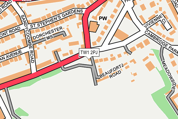
TW1 2PJ is located in the Twickenham Riverside electoral ward, within the London borough of Richmond upon Thames and the English Parliamentary constituency of Twickenham. The Sub Integrated Care Board (ICB) Location is NHS South West London ICB - 36L and the police force is Metropolitan Police. This postcode has been in use since January 1980.


GetTheData
Source: OS OpenMap – Local (Ordnance Survey)
Source: OS VectorMap District (Ordnance Survey)
Licence: Open Government Licence (requires attribution)
| Easting | 517302 |
| Northing | 173947 |
| Latitude | 51.452365 |
| Longitude | -0.313225 |
GetTheData
Source: Open Postcode Geo
Licence: Open Government Licence
| Country | England |
| Postcode District | TW1 |
| ➜ TW1 open data dashboard ➜ See where TW1 is on a map ➜ Where is Twickenham? | |
GetTheData
Source: Land Registry Price Paid Data
Licence: Open Government Licence
Elevation or altitude of TW1 2PJ as distance above sea level:
| Metres | Feet | |
|---|---|---|
| Elevation | 10m | 33ft |
Elevation is measured from the approximate centre of the postcode, to the nearest point on an OS contour line from OS Terrain 50, which has contour spacing of ten vertical metres.
➜ How high above sea level am I? Find the elevation of your current position using your device's GPS.
GetTheData
Source: Open Postcode Elevation
Licence: Open Government Licence
| Ward | Twickenham Riverside |
| Constituency | Twickenham |
GetTheData
Source: ONS Postcode Database
Licence: Open Government Licence
| December 2023 | Theft from the person | On or near Vivienne Close | 271m |
| December 2023 | Criminal damage and arson | On or near Vivienne Close | 271m |
| December 2023 | Public order | On or near Parking Area | 443m |
| ➜ Get more crime data in our Crime section | |||
GetTheData
Source: data.police.uk
Licence: Open Government Licence
| St Stephens Churchrichmond Rd | St Margarets | 73m |
| St Stephens Churchrichmond Rd | St Margarets | 112m |
| Marble Hill Park Crown Road | St Margarets | 221m |
| Marble Hill Park Crown Road (Richmond Road) | St Margarets | 260m |
| Poplar Court (St Margarets Road) | Richmond | 270m |
| Richmond Underground Station | Richmond | 1,465m |
| St Margarets (London) Station | 0.6km |
| Twickenham Station | 1.2km |
| Richmond (London) Station | 1.4km |
GetTheData
Source: NaPTAN
Licence: Open Government Licence
| Percentage of properties with Next Generation Access | 100.0% |
| Percentage of properties with Superfast Broadband | 100.0% |
| Percentage of properties with Ultrafast Broadband | 100.0% |
| Percentage of properties with Full Fibre Broadband | 100.0% |
Superfast Broadband is between 30Mbps and 300Mbps
Ultrafast Broadband is > 300Mbps
| Percentage of properties unable to receive 2Mbps | 0.0% |
| Percentage of properties unable to receive 5Mbps | 0.0% |
| Percentage of properties unable to receive 10Mbps | 0.0% |
| Percentage of properties unable to receive 30Mbps | 0.0% |
GetTheData
Source: Ofcom
Licence: Ofcom Terms of Use (requires attribution)
GetTheData
Source: ONS Postcode Database
Licence: Open Government Licence


➜ Get more ratings from the Food Standards Agency
GetTheData
Source: Food Standards Agency
Licence: FSA terms & conditions
| Last Collection | |||
|---|---|---|---|
| Location | Mon-Fri | Sat | Distance |
| Cambridge Park | 18:30 | 11:15 | 38m |
| Post Office, 336 Richmond Road | 18:30 | 12:15 | 271m |
| Woodside, Cambridge Park | 18:30 | 11:15 | 311m |
GetTheData
Source: Dracos
Licence: Creative Commons Attribution-ShareAlike
| Facility | Distance |
|---|---|
| Cambridge Park Indoor Bowls Club Cambridge Park, Twickenham Indoor Bowls | 195m |
| Marble Hill Park Richmond Road, Twickenham Grass Pitches, Outdoor Tennis Courts | 281m |
| Orleans Park School Richmond Road, Twickenham Sports Hall, Artificial Grass Pitch, Grass Pitches, Studio, Outdoor Tennis Courts | 587m |
GetTheData
Source: Active Places
Licence: Open Government Licence
| School | Phase of Education | Distance |
|---|---|---|
| Deer Park School 389 Richmond Road, Twickenham, TW1 2EF | Primary | 440m |
| Orleans Park School Richmond Road, Twickenham, TW1 3BB | Secondary | 586m |
| Orleans Primary School Hartington Road, Twickenham, TW1 3EN | Primary | 599m |
GetTheData
Source: Edubase
Licence: Open Government Licence
The below table lists the International Territorial Level (ITL) codes (formerly Nomenclature of Territorial Units for Statistics (NUTS) codes) and Local Administrative Units (LAU) codes for TW1 2PJ:
| ITL 1 Code | Name |
|---|---|
| TLI | London |
| ITL 2 Code | Name |
| TLI7 | Outer London - West and North West |
| ITL 3 Code | Name |
| TLI75 | Hounslow and Richmond upon Thames |
| LAU 1 Code | Name |
| E09000027 | Richmond upon Thames |
GetTheData
Source: ONS Postcode Directory
Licence: Open Government Licence
The below table lists the Census Output Area (OA), Lower Layer Super Output Area (LSOA), and Middle Layer Super Output Area (MSOA) for TW1 2PJ:
| Code | Name | |
|---|---|---|
| OA | E00019590 | |
| LSOA | E01003895 | Richmond upon Thames 009D |
| MSOA | E02000792 | Richmond upon Thames 009 |
GetTheData
Source: ONS Postcode Directory
Licence: Open Government Licence
| TW1 2NT | Richmond Road | 68m |
| TW1 2NS | Gibson Mews | 77m |
| TW1 2JG | Cambridge Park | 79m |
| TW1 2NP | Richmond Road | 93m |
| TW1 2PQ | Beaufort Road | 96m |
| TW1 2JE | Cambridge Park | 104m |
| TW1 2NW | Richmond Road | 115m |
| TW1 2LE | Dorchester Mews | 130m |
| TW1 2NN | Richmond Road | 132m |
| TW1 2PF | Cambridge Park | 146m |
GetTheData
Source: Open Postcode Geo; Land Registry Price Paid Data
Licence: Open Government Licence